


Aerial photography vs satellite imagery?
Aerial photography and satellite imagery both show the Earth from above, but they’re not the same thing. The choice depends on what you need to see, how much detail you need, how often you need updates, and how the imagery will be used.
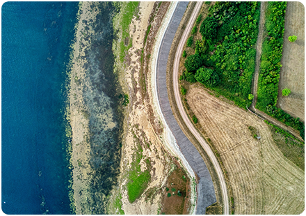
Aerial photography is usually captured from aircraft, drones or other airborne platforms. It is often used when you need a clear, detailed view of land, buildings, roads, boundaries, vegetation, sites or assets. For many planning, property, infrastructure and environmental workflows, aerial photography provides a level of visual detail that’s extremely useful alongside mapping data.
Satellite imagery is captured from satellites orbiting the Earth. It is used when you need to look at larger areas, monitor change over time, or analyse the landscape using different spectral bands. That makes it useful for environmental monitoring, agriculture, land cover analysis, climate work, disaster response and regional-scale planning.
What are the technical differences?
Resolution is one of the main differences. Aerial photography will often show finer detail, especially where high-resolution imagery is available. That helps identify features such as buildings, vegetation, roof structures, road markings, paths, surface changes or site conditions. Satellite imagery can cover much wider areas and may be updated more frequently, depending on the satellite and product, but each pixel usually represents a larger area on the ground.
There is also a difference in how the imagery is used. Aerial photography is commonly used as a visual layer in GIS, planning, asset management, land referencing and design workflows. It helps people understand what a site looks like, especially when used alongside datasets such as OS MasterMap Topography Layer.
Satellite imagery is often used for analysis as well as viewing. Because many satellites capture information beyond visible light, they can help identify patterns that are harder to see in standard photography. For example, satellite data can support vegetation monitoring, flood assessment, land-use change, soil and crop analysis, and large-scale environmental reporting.
In many GIS workflows, the two can also work together. Aerial photography can provide the detailed local view, while satellite imagery can provide wider context and change detection. The right choice depends on the scale of the task, the level of detail required, the update frequency needed, and the type of decisions you are trying to support.
If you need imagery for a project, we can help you understand which data source is most appropriate. Whether you need detailed aerial photography, satellite imagery, OS mapping products or a combination of datasets, the aim is to give you the right visual and spatial context for better decisions.
How Emapsite can help
If you can't find exactly what you need, we can help you choose the right mapping data solution for your project via email, chat or over the phone.
For more information, reach out to our Customer Support team.
Need help with another topic? Learn more in our Knowledge Hub.
Latest News

OS NGD Explained: A beginner’s guide to Ordnance Survey’s National Geographic Database
Learn what the OS National Geographic Database (OS NGD) is, how it works, and why it matters. A simple guide to Britain’s next-generation geospatial data platform.
Read Full Article-
UK geospatial data licensing - A practical guide | OS Mastermap licensing explained
Read Full Article -
Six Location Data Challenges for Consultancies | Emapsite
Read Full Article