


How can location intelligence support climate resilience in utilities?
Climate risk isn’t distributed evenly, and climate resilience starts with understanding the whereabouts of risk. For utilities, the process seems obvious – location intelligence connects assets and networks with data about flooding, extreme weather, terrain, land use and the changing environment – but in reality, it’s slightly more complex.
Two assets performing exactly the same function may face very different threats because of where they are located. Understanding those differences helps utilities decide where resilience measures, maintenance or investment should be prioritised.
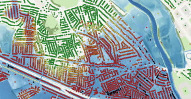
Flood data provides an obvious example. By combining asset locations with river, coastal and surface-water flood information, utilities can identify infrastructure that may be exposed as flood conditions change – but those changing flood conditions aren’t represented by a static dataset. Currency is incredibly important to climate resilience work. Elevation and terrain data are less likely to change in the UK, as there are few tectonic considerations, but across the board, geospatial data helps teams understand how water may interact with the landscape surrounding critical assets.
Other datasets extend the analysis. Land cover and vegetation information can help assess the environment around infrastructure, while buildings, transport networks and water features can reveal dependencies and potential consequences if an asset is disrupted.
The OS National Geographic Database (OS NGD) provides a detailed and regularly updated geographic foundation for this work. Its interconnected information about buildings, land, transport, water and addresses can be combined with a utility’s own network data and environmental datasets to create a more complete picture of exposure.
It must be said, open data has an important role here, too. Climate-resilience analysis may require insight from multiple public bodies, covering everything from flooding and geology to environmental conditions and population. Managing that influx of datasets is a challenge, not only for GIS teams but also for those using the outputs. Idox Geospatial's theMapCloud brings together more than 300 curated open datasets, reducing the work involved in finding, preparing and maintaining those sources individually.
Location intelligence can also help utilities move from identifying hazards to understanding what the consequences might be for their portfolio: which assets are exposed, what else depends on them, which customers could be affected, and where intervention would have the greatest value.
Idox Geospatial helps utilities bring OS NGD, their own asset information and relevant environmental and open datasets together to support climate adaptation. That creates a stronger evidence base for deciding where networks are most vulnerable – and where investment in resilience makes the most difference.
How Emapsite can help
If you can't find exactly what you need, we can help you choose the right mapping data solution for your project via email, chat or over the phone.
For more information, reach out to our Customer Support team.
Need help with another topic? Learn more in our Knowledge Hub.
Latest News

OS NGD Explained: A beginner’s guide to Ordnance Survey’s National Geographic Database
Learn what the OS National Geographic Database (OS NGD) is, how it works, and why it matters. A simple guide to Britain’s next-generation geospatial data platform.
Read Full Article-
UK geospatial data licensing - A practical guide | OS Mastermap licensing explained
Read Full Article -
Six Location Data Challenges for Consultancies | Emapsite
Read Full Article