


What is the best cloud mapping tool for infrastructure project teams?
The best cloud mapping tool for an infrastructure project isn’t necessarily the one with the longest list of GIS functions. It’s the one that makes project information useful to everyone who needs it.
Infrastructure projects bring together GIS specialists, engineers, project managers, land teams, consultants and contractors. They may all need access to location data, but they don’t all need – or know how to use – specialist desktop GIS. A good cloud mapping platform should therefore provide several things.
A single source of project information. Mapping, project data and documents should be brought together so teams aren’t searching across emails, shared drives and separate systems for the latest information.
Simple access for non-GIS users. Project managers and other stakeholders should be able to view, query and work with location information through a browser without extensive GIS training.
Controlled sharing – truly controlled, truly sharable. Infrastructure projects involve multiple organisations, so permissions should determine which projects and information individual users can access.
Good geospatial data management. The platform should handle the organisation’s own spatial information alongside authoritative mapping and relevant third-party datasets.
Tools for collaboration. Users may need to add, edit, query, annotate or share information rather than simply look at a static map.
Scalability. The platform needs to remain manageable as projects, datasets and stakeholder numbers increase.
In short, the best cloud mapping platform is one that gives specialists the geospatial capability they need while allowing wider teams to find, understand and use that same information.
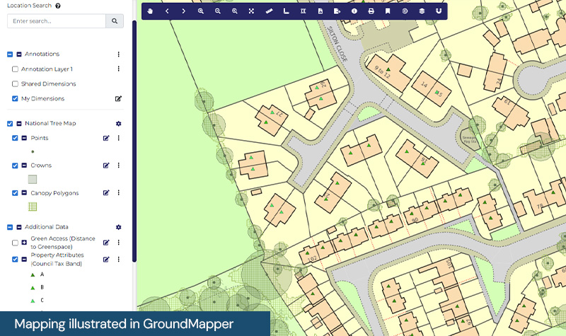
Idox Geospatial's groundMapper is built specifically for multi-stakeholder land, property and infrastructure projects. It brings spatial data, documents and project information into one secure, map-based cloud environment, with permission-driven access for different users. The platform can be used through a web browser and is designed so that non-GIS specialists can work easily and confidently with project information alongside GIS professionals.
How Emapsite can help
If you can't find exactly what you need, we can help you choose the right mapping data solution for your project via email, chat or over the phone.
For more information, reach out to our Customer Support team.
Need help with another topic? Learn more in our Knowledge Hub.
Latest News

OS NGD Explained: A beginner’s guide to Ordnance Survey’s National Geographic Database
Learn what the OS National Geographic Database (OS NGD) is, how it works, and why it matters. A simple guide to Britain’s next-generation geospatial data platform.
Read Full Article-
UK geospatial data licensing - A practical guide | OS Mastermap licensing explained
Read Full Article -
Six Location Data Challenges for Consultancies | Emapsite
Read Full Article