Risk and Perils Data
A portfolio of geo-coded perils models built with a number of key organisations for the insurance sector.
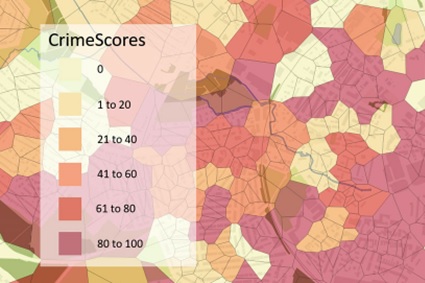
Ambiental UK Crime Model
Identify areas and properties at risk from burglary, arson and criminal damage.
Product DetailsUK CrimeScore™ is a postcode level dataset designed for the Insurance industry. Updated annually, in April, UK CrimeScore™ provides details about insurance claims for criminal damage, burglary and arson during the period in the UK (excluding the Channel Islands and Isle of Man).
UK CrimeScore™ uses the last five years of crime data and demographic data to generate an overall CrimeScore™ for each postcode in Great Britain and Northern Ireland (excluding Channel Islands and Isle of Man). Anyone who wants to understand the likelihood of crime will benefit from using UK CrimeScore™, but its strength is as a tool for insurers.
- UK CrimeScore™ uses crime data sourced from local police forces. It contains anonymised data, spatially linked to the centre point of the street in which the crime was recorded.
- Data is normalised to the number of crimes recorded per 10,000 households over the last five years (2014-2020), but it also includes a prediction for crime rates in 2021.
- Risk ratings range from 0-100 (100=highest) where a score of 50 denotes twice the risk as a value of 25.
Technical Details
- Supplier
- Ambiental
- Update Cycle
- Annually
- Coverage
- United Kingdom (excluding Channel Islands and Isle of Man
- Formats Available
- Spatial data (.GDB) or flat-file (.CSV)
- Licence Options
- 1 year or 3 year contracts
Related Products
OS MasterMap Topography Layer, AddressBase Plus
Download Samples
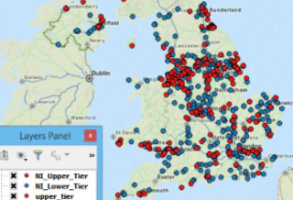
Emapsite UK COMAH Dataset
COMAH locations – high risk locations ranging from Sellafield to Calor Gas centres, geocoded (geo-referenced) to postcode unit level.
Product DetailsThe emapsite UK Major Accident Hazard dataset comprises the latest officially reported COMAH addresses published by the Health and Safety Executive, geocoded (geo-referenced) to postcode unit level. Geographic coverage is England, Scotland, Wales and N. Ireland.
The Control of Major Accident Hazards (COMAH) Regulations 2015 and registration requirements came into effect on 1 June 2015. COMAH are the enforcing regulations within the United Kingdom of the Seveso II Directive devised in Brussels following the Seveso disaster. They are applicable to any establishment storing or otherwise handling large quantities of industrial chemicals of a hazardous nature. Types of establishments required to register include chemical warehousing, chemical production facilities and some distributors.
The principal aim of the regulations is to reduce the risks of potential major accidents, such as the Flixborough disaster, that are associated with the handling of hazardous substances.
- COMAH regulations operate on two hazard levels based on each establishment's inventory and associated risk status; 'Lower Tier' and 'Upper Tier'. Tier level is indicated in the dataset along with each establishments geocode (x,y and latitude longitude geo-reference).
- Risk analysts, underwriters and actuaries can rate risk at a local level with an understanding of proximity to Major Accident Hazard locations to make optimal pricing and portfolio decisions.
Technical Details
- Supplier
- emapsite
- Coverage
- England, Scotland, Wales and N.Ireland
- Formats Available
- CSV or webservice
- Licence Options
- Annual
- Delivery Timescale
- On request
Related Products
OS MasterMap Topography Layer, AddressBase Plus
Download Samples
BGS Radon
This HPA-BGS radon potential dataset is for use in GIS software.
Product DetailsThe data can be used to answer one of the standard legal enquiries on house purchase in England and Wales (CON29 Standard Enquiry of Local Authority: 3.13 Radon Gas: Location of the Property in a Radon Affected Area). It also provides information on the level of protection required for new dwellings under BR211 (2007) Radon: guidance on protective measures for new buildings.
Please contact us at sales@emapsite.com for further details or a quote.
Technical Details
- Supplier
- British Geological Survey
- Update Cycle
- Annual
- Coverage
- GB
- Formats Available
- SHP and webservice
- Licence Options
- Annual
- Delivery Timescale
- Up to 4 working hours