
Address & Property Information
Address data is pivotal for facilitating deliveries, enabling location-based services, enhancing customer experience, and supporting decision making. It is essential for the planning and delivery of Government services and emergency service responsiveness and is a key building block for building applications. As well as saving time, money and resources, correct addressing information helps prevent fraud and save lives.
Emapsite provides address data products from the following publishers:
• Emapsite Addressible (geocoded addresses from Royal Mail PAF/MR/Alias)
• Ordnance Survey AddressBase products
• Ordnance Survey Code-Point products
• Ordnance Survey Points of Interest

Property Ownership Information
Property ownership datasets aid planning and development activities, ensuring that development proposals align with regional development goals/policies and improving the likelihood of securing planning permission.
Emapsite combines address data with property ownership information from HM Land Registry, energy information from Ministry of Housing, Communities and Local Government (MHCLG) and planning information from Local Authority Planning Departments for a rounded view of land parcels and property ownership:
• Emapsite LandPack products (HMLR/EPC data)
• HMLR Title Registers ('online copies')
• Idox Local Plans (including Strategic Housing Land Availability Assessment - SHLAA
• Idox Public Rights of Way
These products are described in more detail below.
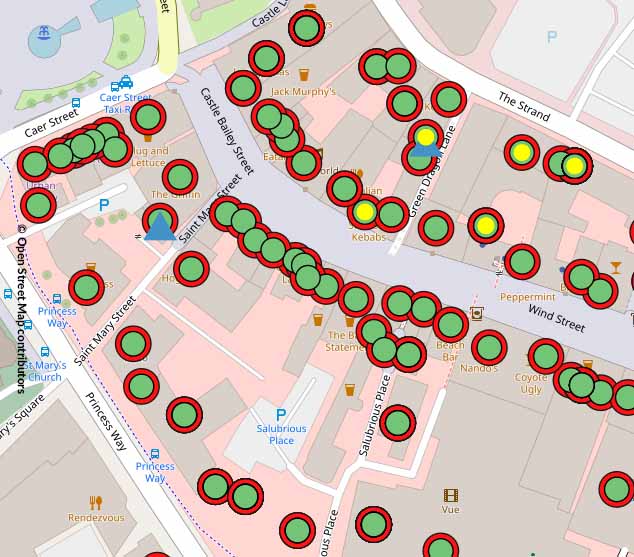
Emapsite Addressible
Over 30 million geocoded address records from Royal Mail Postcode Address File (PAF, MR, Alias) with unique property reference number (UPRN) and map coordinates.
Product DetailsLinks over 30 million Royal Mail address records in Great Britain with location information including map coordinates (British National Grid), unique property reference number (UPRN) and Ordnance Survey topographical identifier (TOID). Includes address information from Royal Mail Postcode Address File (PAF), Multi-Residence File, Alias File and Welsh Language File.
Emapsite Addressible is a GB address dataset comprising Royal Mail address information with positional data. It is intended to be the basis of address lookup services for both internal use (e.g. customer helpdesk) and external use (e.g. webform completion) as well as managing final mile delivery services.
The product contains over 30 million addresses, 1.8 million post codes and 1.4 million business names. It combines address information from Royal Mail Postcode Address File (PAF), Multi-Residence File, Alias File and Welsh Language File with location coordinates (X/Y and Lat/Long), topographical identifier (TOID) and unique property reference number (UPRN). The product joins the various files and attributes via the Royal Mail UDPRN (Unique Delivery Point Reference Number) and links all residencies at a location with a UPRN. It is supplied as a GB dataset and a sample file is available for a small area of the city and county of Swansea (Welsh: Abertawe).
Also available as an XML Query-API service.
Licence: PDF
Technical Details
- Supplier
- Emapsite
- Update Cycle
- Quarterly
- Coverage
- GB
- Scale
- Formats Available
- CSV
- Stated Accuracy
- Stated Accuracy
- Stated Accuracy
- Licence Options
- Annual
- Delivery Timescale
- Within 24 hours
Related Products
OS National Geographic Database (NGD)
Emapsite LandPack property information (HM Land Registry)
Download Samples

AddressBase Products
Address data produced and maintained by Geoplace (the centre of excellence for spatial address and street information in Great Britain.
Product DetailsAddressBase products
Address data produced and maintained by Geoplace (the centre of excellence for spatial address and street information in Great Britain, with input from all local government authorities in GB and distributed by Ordnance Survey Partners.
AddressBase products are used in every property-related use case.
AddressBase Premium
Over 40 million address records from Local Authorities and Royal Mail and non-postal addresses matched to unique property reference numbers (UPRN) as soon as planning permission is granted, and with full address lifecycle information from provisional addresses to current and historic addresses (demolished). Includes 'quaternary' level address classifications (commercial addresses only) and Valuation Office Agency information. Relational database model with individual tables for BS7666 and PAF structure.
AddressBase Islands
For customers who licence AddressBase Plus or AddressBase Premium, AddressBase Islands is an add-on, addressing gazetteer of properties in Northern Ireland, Isle of Man and the Channel Islands (Guernsey and Jersey). It contains around 1 million addresses and is available as a complete set.
AddressBase Plus
c.37 million address records from Local Authorities and Royal Mail, and non-postal addresses such as places of worship, community halls and telephone boxes, matched to unique property reference numbers (UPRN). Includes 'tertiary' level address classifications (e.g. residential, dwelling, detached) and Valuation Office Agency information. BS7666 and PAF data structure.
AddressBase Core
c.34 million address records from Local Authority holdings of National Land and Property Gazetteer (NLPG) and One Scotland Address Gazetteer, matched to unique property reference numbers (UPRN). Includes a single line address attribute and 'secondary' level address classifications (e.g. residential, dwelling) and updated weekly.
AddressBase
c.30 million Royal Mail Postcode Address File (PAF)® address records matched to unique property reference numbers (UPRN), bringing a new dimension to matched records. Includes basic address classification to identify residential and commercial addresses.
Licence: PDF
Technical Details
- Supplier
- Ordnance Survey
- Update Cycle
- 6-weekly (except AddressBaseCore - weekly)
- Coverage
- GB
- Scale
- 1:1 250 to 1:10 000
- Formats Available
- CSV, GML
- Stated Accuracy
- Sub 1 metre
- Stated Accuracy
- Stated Accuracy
- Sub-metre
- Licence Options
- Annual
- Delivery Timescale
- Usually within minutes
Related Products
OS National Geographic Database (NGD)
Emapsite LandPack property information (HM Land Registry)
Download Samples
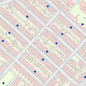
OS Code-Point Products
Provides map coordinates and other information for around 1.8 million postcode units in UK.
Product DetailsThese products indicate the notion position and boundaries of postcode units (e.g. ST2 8AD) with additional information, including:
Number and type of delivery points (domestic and non-domestic)
- • A positional quality indicator
- • A country indicator
- • Postcode type (e.g. large user, small users)
- • Codes for National Health Service regions and areas
- • Codes for local government counties, districts and wards.
- • Lookup table for 'vertical streets' (i.e. more than one postcode in a single building).
They are used for site location, market analysis and profiling, socio-economic profiling, health and epidemiology studies, route planning and resource allocation and much more.
OS Code-Point
OS Code-Point provides the map coordinate for the calculated mean position of delivery points in every postcode unit in Great Britain and Northern Ireland (around 1.8 million postcode units). This product provides considerably more information and insight than the OpenData version.
Code-Point with Polygons
Code-Point with Polygons indicates the notional area of postcode units in England, Scotland and Wales (around 1.7 million postcode units). The area polygons contain Royal Mail Postcode Address File (PAF) address records having the same postcode and follow major physical features that help define a postcode boundary.
Buy OS Code-Point with Polygons
Licence: PDF
Technical Details
- Supplier
- Ordnance Survey
- Update Cycle
- Quarterly
- Coverage
- GB and NI
- Scale
- 1:1250 to 1:10,000
- Formats Available
- CSV, SHP
- Stated Accuracy
- 1 metre
- Stated Accuracy
- Stated Accuracy
- Licence Options
- Annual
- Delivery Timescale
- Usually within minutes
Related Products
OS National Geographic Database (NGD)
Emapsite LandPack property information (HM Land Registry)
Download Samples
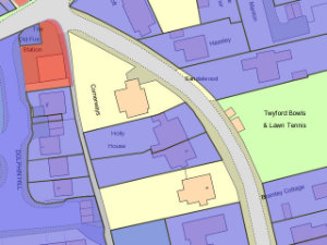
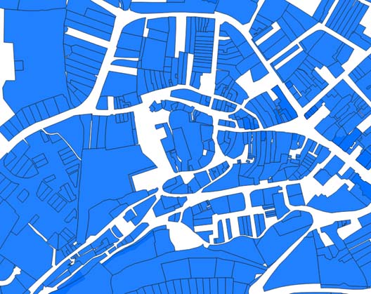
Emapsite LandPack Title and Tenure
Emapsite LandPack Title & Tenure combines HM Land Registry (HMLR) residential and commercial ownership information for England & Wales with OS MasterMap Topography Layer mapping.
Product DetailsEmapsite LandPack Title & Tenure combines HM Land Registry (HMLR) residential and commercial ownership information for England & Wales with OS MasterMap Topography Layer mapping. And with climate-change at the top of the agenda, the product also provides a selection of property information, current energy efficiency/emissions data from energy performance certificates records where available (EPC).
- • OS MasterMap Topography Layer
The definitive, digital respresentation of landscape features in Great Britain. - • HM Land Registry information
Contains more than 26 million Titles showing evidence of ownership and a complete data dictionary of field headings and definitions. Includes Title number, Tenure information and UPRN (where relevant) of land parcels with indicative locations of a registered title (‘index’ polygon ID, geometry) and Title Descriptors information (describing legal interests that are recorded against freehold and leasehold estates). - • EPC Data (Ministry of Housing, Communities and Local Government)
A selection of property information from Energy Performance Certificates records where available, including property type, built form and construction age plus current energy consumption, energy rating, efficiency and carbon dioxide (CO2) emissions.
Emapsite LandPack Title & Tenure is ideal land and property planning, site development and asset management activities. It can be purchased as a national 'set' or for customer-defined areas-of-interest in a range of data formats.
Buy Emapsite LandPack Title & Tenure
Licence: PDF
Technical Details
- Supplier
- Emapsite/HM Land Registry
- Update Cycle
- 6-weekly
- Coverage
- England and Wales
- Scale
- 1:1250 to 1:10 000
- Formats Available
- SHP, GDB, DWG
- Stated Accuracy
- Stated Accuracy
- Stated Accuracy
- Licence Options
- Annual
- Delivery Timescale
- Usually within minutes
Related Products
OS National Geographic Database (NGD)
Emapsite LandPack property information (HM Land Registry)
Download Samples
LandPack HMLR Products
Provides HM Land Registry (HMLR) residential and commercial land and property ownership information for England & Wales supplemented with selected EPC data, where available.
Product DetailsLandPack HMLR products are useful for land and property planning, site development and asset management activities. They can be purchased individually or as a bundle for customer-defined areas-of-interest or as a national 'set' or in a range of data formats.
Emapsite LandPack Polygons
Contains HMLR Title number, tenure information and unique property reference number (UPRN) where relevant of land parcels, with indicative locations of a registered title (‘index’ polygon ID, geometry) and Title Descriptors information (describing legal interests that are recorded against freehold and leasehold estates).
Also contains a selection of property information from Ministry of Housing, Communities and Local Government (MLCLG) EPC data , including property type, built form and construction age plus current energy consumption, energy rating, efficiency and carbon dioxide (CO2) emissions.
Buy Emapsite LandPack Polygons
Emapsite LandPack Commercial Ownership
Combines information from the HMLR datasets formerly known as Commercial and Corporate Ownership data (CCOD) and Overseas Companies Ownership Data (OCOD) for UK and overseas companies respectively. Includes indicative locations of a registered title (‘index’ polygon ID, geometry) for commercial owned land/property, address, proprietor name and company registration number, proprietor type (e.g. Limited or Public Limited company, Local Government, Housing Association etc.), title and tenure. The data does not show land or property owned by private individuals or charities (including Charitable Incorporated Organisations).
Also contains a selection of property information from Ministry of Housing, Communities and Local Government (MLCLG) EPC data , including property type, built form and construction age plus current energy consumption, energy rating, efficiency and carbon dioxide (CO2) emissions. from Ministry of Housing, Communities and Local Government (MLCLG) EPC data described above.
Buy Emapsite LandPack Commercial Ownership
Emapsite LandPack Polygons with Commercial Ownership
A bundle of Emapsite LandPack Polygons and Emapsite LandPack Commercial Ownership datasets.
Buy Emapsite LandPack Polygons with Commercial Ownership
Technical Details
- Supplier
- Emapsite
- Update Cycle
- Quarterly
- Coverage
- England and Wales
- Scale
- 1:1250
- Formats Available
- SHP, GDB, DWG, DXF, GML
- Stated Accuracy
- Stated Accuracy
- Stated Accuracy
- Licence Options
- Annual
- Delivery Timescale
- Usually within minutes
Related Products
OS National Geographic Database (NGD)
Emapsite LandPack property information (HM Land Registry)
Download Samples

Idox Planning Products
Idox Planning Products contains provides data about Local Development Plans (LDP), Strategic Housing Land Availability Assessments (SHLAA) and Publi Rights of Way (PRoW) in Great Britain.
Product DetailsIdox Local Plans
Idox Local Plans provides data about Local Development Plans (LDP) and Strategic Housing Land Availability Assessments (SHLAA) published by local planning authorities in Great Britain. These plans are shaped through public consultations and align with the National Planning Policy Framework (NPPF), ensuring sustainable development. They identify areas for housing, commercial projects, and green spaces within Local Planning Authority areas while protecting heritage sites and biodiversity.
Idox Local Plans was created for land, renewables and housing developers to perform search and analytics activities. It is available for download and as an Open Geospatial Consortium compliant (OGC) web map service (WMS) served in 25 individual layers. The data is intended to help customers save considerable time in sourcing and collating data from individual Planning Authorities and:
- • Rapidly identify sites that are suitable for housing or commercial projects
- • Minimise the likelihood of wasting time and resources on unsuitable locations or selecting non-viable development sites;
- • Align projects with regional development goals/policies improving the chances of securing planning permission.
- Also available as an Open Geospatial Consortium (OGC) compliant web map service (WMS).
Idox Public Rights of Way (PRoW)
Idox Public Rights of Way (known as Core Paths in Scotland) helps developers identify and account for any PRoW on or near their site of interest in Great Britain. PRoWs such as footpaths, bridleways, byways and others are protected under UK law, and any obstruction, alteration, or removal of a PRoW without proper authorisation can result in legal action, fines, or enforcement orders. The data helps to ensure that project delivery is in line with community expectations whilst satisfying statutory duties with respect to regulatory frameworks.
Technical Details
- Supplier
- Emapsite
- Update Cycle
- Quarterly
- Coverage
- GB
- Scale
- Formats Available
- GPKG
- Stated Accuracy
- Stated Accuracy
- Stated Accuracy
- Licence Options
- Annual
- Delivery Timescale
- Within 24 hours
Related Products
OS National Geographic Database (NGD)
Download Samples
OS Points of Interest
GB coverage of categorised points of interest - commercial, industrial, retail, tourism, leisure, government - including addresses and coordinates.
Product detailsOS Point of Interest contains over four million records of vector points, sourced and quality-checked from over 100 leading listing suppliers. Locations and organisation names as well as several levels of classification enable selections of points to be fine tuned down to type of establishment or organisation
- • Accommodation
- • Eating and drinking
- • Commercial services
- • Attractions
- • Sport and entertainment
- • Education and health
- • Public infrastructure
- • Manufacturing and production
- • Retail
- • Transport
Around half of Points of Interest records are businesses, with commercial addresses, telephone numbers and website addresses, plus company classifications for site analysis.
Technical Details
- Supplier
- Ordnance Survey
- Update Cycle
- Quarterly
- Coverage
- GB
- Scale
- 1:1250 to 1:10,000
- Formats Available
- SHP, GML, TAB
- Stated Accuracy
- Stated Accuracy
- Stated Accuracy
- Licence Options
- Annual
- Delivery Timescale
- Typically within 4 working hours
Related Products
OS National Geographic Database (NGD)
Emapsite LandPack property information (HM Land Registry)
Download Samples

HMLR Title Register with Polygon
Provides HM Land Registry Title Register document and data, including Title Plan area geometry for land and properties in England & Wales.
Product DetailsHMLR Title Register with Polygon is a bundle containing an ‘online copy’ of a HM Land Registry Title Register (PDF) together with files containing data extracted from the Register plus the unique property reference number (UPRN) and Title Plan geometry. The product is intended to aid data visualisation in research and analysis activities in land and property use cases.
HM Land Registry (HMLR) Title Registers are the official records of land and property ownership in England & Wales. They describe who owns land a property, the type of ownership (freehold, leasehold) and any restrictions or charges affecting the land.
Any number of Title Registers may be ordered by defining an area of interest in the Emapsite mapshop or by emailing a list of Title-IDs through Customer Services.
Technical Details
- Supplier
- Emapsite
- Update Cycle
- Not applicable
- Coverage
- England & Wales
- Scale
- Formats Available
- PDF (Register); CSV (associated data)
- Stated Accuracy
- Stated Accuracy
- Stated Accuracy
- Licence Options
- Perpetual
- Delivery Timescale
- Within 24 hours
Related Products
OS National Geographic Database (NGD)
Emapsite LandPack property information (HM Land Registry)
Download Samples

BGS Radon Potential
Definitive map of radon-affected areas in Great Britain and Northern Ireland.
Product DetailsBGS Radon Potential combines indoor Radon measurements for around half a million homes across Great Britain and around 25,000 homes in Northern Ireland provided by UK Health Security Agency (formerly Public Health England) with BGS 1:50 000 scale geology.
Radon is a natural radioactive gas, which enters buildings from the ground and persists or accumulates where ventilation is poor. It is the biggest source of human exposure to ionising radiation with prolonged exposure increasing the risk of lung cancer. The data informs about ground conditions in properties relating to health protection.
Updated in December 2022, it classifies areas based on their likelihood of a property having a radon level at or above the ‘Action Level’ in Great Britain requiring corrective action (200 becquerel per cubic metre). The dataset provides an assessment in six classes (1-6, low to high) of the likelihood of a dwelling having a radon concentration at or above the action Level rather than the actual radon level within a specific dwelling. The action level indicates where it may be necessary to apply preventative measures in new buildings and extensions.
Useful for site development and construction activities.
Technical Details
- Supplier
- BGS - British Geological Society
- Update Cycle
- Not applicable
- Coverage
- Great Britain and Northern Ireland
- Scale
- 1:50 000
- Formats Available
- SHP, TAB
- Stated Accuracy
- Stated Accuracy
- Stated Accuracy
- Licence Options
- Annual
- Delivery Timescale
- Within 24 hours
Related Products
OS National Geographic Database (NGD)
Emapsite LandPack property information (HM Land Registry)
Download Samples

Unrivalled resources
We simplify the supply and management of mapping products, plans and reports. Blending diverse datasets to uncover hidden commercial insights.

Business intelligence
Our spatial intelligence enables our clients to pinpoint areas of risk and reward, and to make better business decisions faster.

Proven partnership
We work in partnership, we're supportive, and we're committed to reducing our own and our clients' impact on the environment.