
Marine data from Emapsite
Ocean vision? See the bigger picture
Create tailor-made marine maps with the dataset filters that matter to your organisation – in an instant.
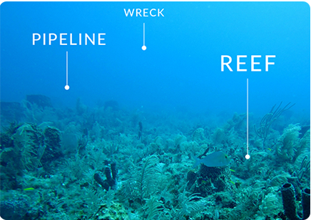
From shipping routes and industrial facilities, to pipelines and wrecks, if you work in a maritime environment, you’ll know that there’s a whole world hidden beneath the waves. It’s an environment where accuracy matters.
Empower your decision-making with up-to-date, pinpoint marine location data visualised on maps with parameters defined by you. Scrutinise specific areas of ocean anywhere in the world*.
Get only the marine insights you need, including an option to integrate with coastal land data.
Set up, purchase and access your maps fast and with online ease.
*Where available

Marine data? Go deeper
Our market-leading marine data platform provides matchless access to marine maps and data. Choose any combination from multiple datasets to reveal insights into elevation, transport, industrial facilities, geographical regions, administrative & management units, and shipwrecks & obstructions.
Go from data to insight to action quicker than the competition. From pipelines to reefs, shipwrecks to depth contours, discover a world of trusted marine location data at your fingertips.
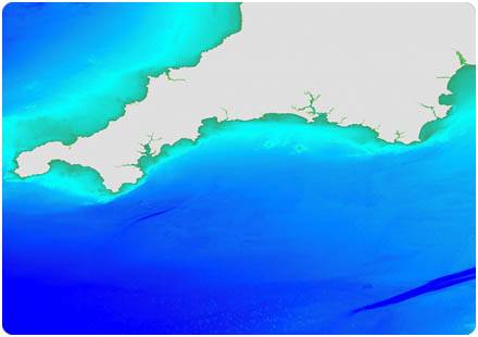
Image (C) Crown Copyright, 2023. All Rights reserved. Licence no. EK001.

Trusted partners
The up-to-date data that powers our marine mapping service is supplied by OceanWise and comes direct from the Hydrographic Office; the official UK government department responsible for charting the seas.
We believe that the power of mapping and location data is limitless. That’s why we’ve been simplifying spatial intelligence and helping customers make better-informed decisions, anticipate risk, and realise opportunities for over 20 years. Build a stronger, more sustainable business with Emapsite.
Order Marine Mapping & Data
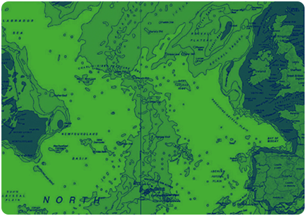
Marine Themes - Large, Medium + Small Scale
Marine Themes comprises authoritative data from the UK & other Hydrographic Offices, engineered into logical data layers for easy loading & efficient GIS use.
Product DetailsMarine Themes - Large, Medium + Small Scale
Created by OceanWise Ltd using data from the UK Hydrographic Office and other agencies. Data derived from Electronic Navigational Charts (ENCs) is used to provide additional coverage.
- Ongoing maintenance schedule to ensure the latest survey data is incorporated.
Image (C) Crown Copyright, 2013. All Rights reserved. Licence no. EMS-EK001. Not to be used for navigation.
Technical Details
- Supplier
- Oceanwise Ltd
- Update Cycle
- Coverage
- UK waters
- Scale
- Various
- Formats Available
- SHP, TAB
- Stated Accuracy
- Stated Accuracy
- Stated Accuracy
- Licence Options
- Annual
- Delivery Timescale
- within 4 working hours
Related Products
Marine Themes - Gridded Sea Bed DEM, Marine Raster Charts
Download Samples
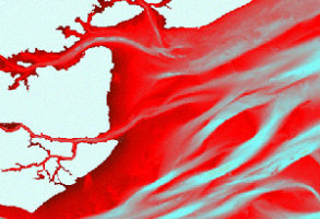
Marine Themes - Sea Bed DEM
A sea bed digital elevation model (DEM) at 1 and 6 arc seconds utilising single and multi-beam hydrographic survey data - Gridded Bathymetry.
Product DetailsCreated by OceanWise Ltd using data from the UK Hydrographic Office and other agencies. Data derived from Electronic Navigational Charts (ENCs) is used to provide additional coverage.
OceanWise Marine Themes DEM offers the following key advantages:
- Survey data modelled to create an accurate and seamless surface of the sea bed.
- Advanced de-confliction methodology improving continuity between surveys.
- Height and slope attributed coastline increasing accuracy within the coastal zone.
- Improved interpolation algorithm providing more natural shape (no flat triangles).
- Ongoing maintenance schedule to ensure the latest survey data is incorporated.
- Already exceptional value, DEM image files in GeoTIFF (or ECW) format provide even greater cost savings for many applications.
Image (C) Crown Copyright, 2013. All Rights reserved. Licence no. EMS-EK001. Not to be used for navigation.
Technical Details
- Supplier
- Oceanwise Ltd
- Update Cycle
- Coverage
- UK waters
- Scale
- Various
- Formats Available
- ASC
- Stated Accuracy
- Stated Accuracy
- Stated Accuracy
- Licence Options
- Annual
- Delivery Timescale
- Within 4 working hours
Related Products
Marine Themes - Gridded Sea Bed DEM, Marine Raster Charts
Download Samples
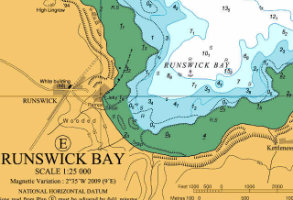
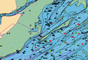
Marine Raster Charts
Familiar nautical chart base map, ready for use in GIS. Small scale charts of seas and regions to large scale charts of harbours and ports.
Product Details
Marine Raster Charts are derived in part from material obtained from the UK Hydrographic Office, supplied as image files for easy loading and use in GIS.The data is supplied in GeoTIFF format at discrete scale levels, cut-out to your chosen area and labelled by Admiralty Chart number for easy referencing. Raster Charts are available worldwide depending on permissions granted by contributing nations.
Image (C) Crown Copyright, 2013. All Rights reserved. Licence no. EMS-EK001. Not to be used for navigation.
Technical Details
- Supplier
- Oceanwise Ltd
- Update Cycle
- Coverage
- UK waters and selected global charts
- Scale
- Various
- Formats Available
- TIFF
- Stated Accuracy
- Stated Accuracy
- Stated Accuracy
- Licence Options
- Annual
- Delivery Timescale
- within 4 working hours
Related Products
Marine Themes - Gridded Sea Bed DEM, Marine Raster Charts
Download Samples
Large, Medium, Small: TIF