
OS Digital Maps
With a huge array of OS Digital maps and data, the Ordnance Survey product suite is unrivalled around the world.
OS products and the value Emapsite can create
Emapsite is a Premier partner of Ordnance Survey. In addition to the full suite of OS Addressbase products, and all other OS data and services, we provide all the support and insights to help you get more value from your mapping.

How Emapsite add value to OS Maps and Data
"Partnerships are about working together to promote the power of geospatial data in solving business problems."
As an OS Partner we can offer Ordnance Survey's world leading data products in a format or web service that suits you. We also pass those products to own own R & D team, who strive to add ever increasing value, to elevate these world class products even higher.
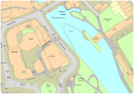
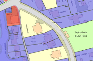
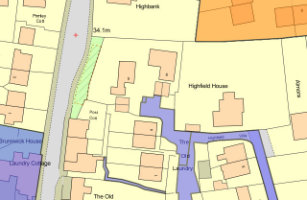
OS MasterMap Topography Layer
OS MasterMap Topography Layer is the most detailed and accurate view of Great Britain's landscape – from roads to fields, to buildings and trees, fences, paths and more.
Product DetailsOS MasterMap is the most detailed, current and comprehensive map dataset of Great Britain, enabling you to make better decisions and manage your assets more effectively. Working with the other mapping layers in the suite, OS MasterMap Topography Layer gives you the visual context to help interpret addresses, routes and imagery. OS MasterMap is the approved dataset for planning applications and land registration.
Continually updated, OS MasterMap contains 450 million geographic features found in the real world, from detailed building and road outlines to water features, pathways, bus shelters and letter boxes.
Licence: PDF
OS MasterMap is ideal for:
- Use in CAD or GIS
- Planning
- Site location and evaluation
- Risk management
- Transport and infrastructure
- Asset management
- Environmental analysis
Technical Details
- Supplier
- Ordnance Survey
- Update Cycle
- 6 weekly
- Coverage
- GB
- Scale
- 1:1250
- Formats Available
- DWG, SHP, GML, TAB, DXF, GDB, KML, TIFF
- Stated Accuracy
- Urban +/- 1m
- Stated Accuracy
- Rural +/- 8m
- Stated Accuracy
- +/- 8m
- Licence Options
- 12, 24 or 36 months
- Delivery Timescale
- Within minutes
Related Products
PDF Plans, Aerial Photography, OS MasterMap Highways Layer, OS Mastermap ITN, OS Mastermap Imagery Layer, Lidar, AddressBase Plus
Download Samples
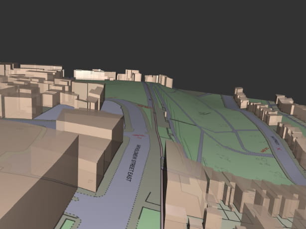
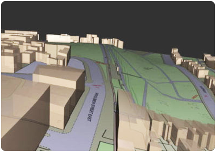
OS MasterMap 3D - Building Heights and OS Terrain 5
OS MasterMap is the most detailed & accurate view of Great Britain's landscape – with roads, fields, buildings, trees, fences & more. Combined with OS Terrain 5 as a single file, saving time & money.
Product DetailsOS MasterMap is the most detailed, current and comprehensive map dataset of Great Britain, enabling you to make better decisions and manage your assets more effectively. Working with the other mapping layers in the suite, OS MasterMap Topography Layer gives you the visual context to help interpret addresses, routes and imagery. OS MasterMap is the approved dataset for planning applications and land registration.
Continually updated, OS MasterMap contains 450 million geographic features found in the real world, from detailed building and road outlines to water features, pathways, bus shelters and letter boxes.
OS MasterMap is ideal for:
- Use in CAD or GIS
- Planning
- Site location and evaluation
- Risk management
- Transport and infrastructure
- Asset management
- Environmental analysis
OS Terrain 5 is ideal for:
OS Terrain 5 is particularly valuable for large scale development projects, planning, impact assessment
OS Terrain 5 offers detailed modelling of significant features such as road, rail, quarries and lakes allowing you to asses the lie of the land on-screen and reduce the need for site visits. OS Terrain 5 has a root mean square error (RMSE) value of 1.5 metres in urban areas and major communication routes.
OS Terrain 5 is maintained as part of the same revision process as the Ordnance Survey's large scale datasets and so adds a valuable third dimension to OS MasterMap Topography Layer.
Licence: PDF
Technical Details
- Supplier
- Ordnance Survey
- Update Cycle
- 6 weekly
- Coverage
- GB
- Scale
- 1:1250 (OS MasterMap) and 5m (Terrain 5)
- Formats Available
- DWG, SHP, PDF
- Stated Accuracy
- Urban +/- 1m (OS MasterMap)
- Stated Accuracy
- Rural +/- 8m (OS MasterMap)
- Stated Accuracy
- +/- 8m (OS MasterMap)
- Licence Options
- 12, 24 or 36 months
- Delivery Timescale
- Within minutes
Related Products
PDF Plans, Aerial Photography, OS MasterMap Highways Layer, OS Mastermap Imagery Layer, Lidar, AddressBase Plus
Download Samples
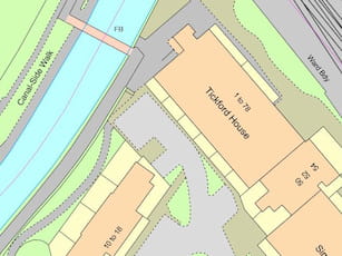
Emapsite Land Title and Tenure
OS MasterMap Topography Layer enriched with HM Land Registry Polygons from the National Spatial Dataset, giving land title, tenure and UPRN.
Product DetailsEmapsite Land Title and Tenure is a new product that enables asset managers to make one simple purchase to cover their large scale mapping needs rather than having to make individual purchases of Land Registry data.
You can purchase Emapsite Land Title and Tenure through our online mapshop, where you can define your area of interest and purchase in a range of GIS formats.
Licence: PDF
Key Facts
- Polygons for all land titles registered with Land Registry
- Polygons are based on OS MasterMap
- Contains a polygon plus the following attributes:
- Title number
- Tenure (Freehold or Leasehold, plus class of tenure)
- Estate interest
- UPRN (where relevant)
- Polygon ID
- Status (registered or pending)
Common uses:
Ideal for project and site specific users in a variety of sectors where land parcel information is required, including planning, site development and asset management.
Technical Details
- Supplier
- HM Land Registry and Ordnance Survey
- Update Cycle
- Monthly
- Coverage
- GB
- Scale
- 1:1250
- Formats Available
- SHP
- Stated Accuracy
- Stated Accuracy
- Stated Accuracy
- Licence Options
- Annual
- Delivery Timescale
- Within minutes
Related Products
OS MasterMap Topography Layer, AddressBase Plus
Download Samples
emapsite Commercial Land Ownership
OS MasterMap enriched with HMLR polygons giving land title, tenure and ownership for registered commercial land.
Product Detailsemapsite Commercial Land Ownership combines OS MasterMap with non-privately owned land ownership data, taken from HM Land Registry's National Spatial Dataset and Commercial and Corporate Dataset. The polygon attributes include the name of the organisation registered as the title owner, company registration number, type of organisation, title number and tenure of the land parcel in question.
emapsite Commercial Land Ownership allows asset managers to make one simple purchase to cover their large scale mapping needs rather than having to make individual purchases of HM Land Registry data. Asset managers in the housing association, commercial and public sectors can request the polygons and title data on all their holdings, sorted by organisation name or company number.
Purchasable as a user defined area through our online mapshop, and deliverable in a range of GIS formats.
Licence: PDF
Key Facts
- A subset of the polygons in emapsite Land Title and Tenure, with extra attributes
- Polygons for all land titles registered with Land Registry which are not owned by a private individual, a charity or a company registered overseas. Includes estate in land owned by:
- Limited or Public Limited companies
- Local and Central Government (e.g. council land, MOD)
- Church lands, universities, independent schools
- Housing associations (all their housing stock)
- Contains a polygon plus the following attributes in both a GIS file and a CSV:
- Address - based on OS address data past or present
- Proprietor (owner) name and company registration number
- Type of proprietor (eg. local gov, housing association)
- Title number and tenure
Common uses:
Ideal for project and site specific users in a variety of sectors where land parcel information is required, including planning, site development and asset management.
Technical Details
- Supplier
- HM Land Registry and Ordnance Survey
- Update Cycle
- Quarterly
- Coverage
- GB
- Scale
- 1:1250
- Formats Available
- SHP
- Stated Accuracy
- Stated Accuracy
- Stated Accuracy
- Licence Options
- Annual
- Delivery Timescale
- On request
Related Products
OS MasterMap Topography Layer, AddressBase Plus
Download Samples
OS VectorMap Local
A highly-detailed, customisable, street-level vector map at 1:10,000 scale, showing physical boundaries around properties, building outlines, paths and street names, for the accurate lie of the land.
Product DetailsOS VectorMap Local is a vector mapping dataset designed to provide contextual mapping outputs. Generated from large-scale source data OS VectorMap Local is ideally suited for applications where 1:10,000 raster backdrop mapping would have previously been used.
VectorMap Local offers the user the flexibility to turn on and off layers of mapping and to style the data as required, allowing the user to create custom maps highlighting their features of interest. Purchasable as a user defined area and deliverable in a range of GIS and CAD formats VectorMap Local is viewable and printable at a variety of scales. The product contains the following features:
• buildings, structures and leisure areas
• roads, paths and tracks
• vegetation and surface features
• water features and associated detail
• railways and associated detail
• spot height
• archaeological and antiquity information
• text
• miscellaneous information – remote areas, foot bridges, house names and all buildings.
Licence: PDF
Technical Details
- Supplier
- Ordnance Survey
- Update Cycle
- Quarterly
- Coverage
- GB
- Scale
- 1:10,000
- Formats Available
- SHP, TAB, GML, DWG
- Stated Accuracy
- Stated Accuracy
- Stated Accuracy
- Licence Options
- Annual
- Delivery Timescale
- Within minutes
Related Products
Download Samples
OS VectorMap Local Raster
Raster version of the popular OS VectorMap Local, ideal as a backdrop image for engineering, environmental and landscape design projects.
Product DetailsOS VectorMap Local Raster replaces OS 1:10,000 colour raster and is designed for providing contextual mapping output, generated from large-scale source information. It is available as both colour and black and white in a range of raster formats.
The product contains the following features:
- buildings, structures and leisure areas
- roads, paths and tracks
- vegetation and surface features
- water features and associated detail
- railways and associated detail
- spot height
- archaeological and antiquity information
- text
- miscellaneous information – remote areas, foot bridges, house names and all buildings
Also available as a non-georeferenced image.
Licence: PDF
Technical Details
- Supplier
- Ordnance Survey
- Update Cycle
- Quarterly
- Coverage
- GB
- Scale
- 1:10,000
- Formats Available
- PNG, TIFF, JPG, BMP
- Stated Accuracy
- Stated Accuracy
- Stated Accuracy
- Licence Options
- Annual
- Delivery Timescale
- Within minutes
Related Products
Download Samples
OS 1:25,000 Raster
Ordnance Survey's 1:25,000 scale mapping of GB is the digital version of OS Explorer - ideal for analysing the environment in a rural area.
Product DetailsThe Ordnance Survey's well-known Explorer series of mapping, familiar to walkers and outdoor enthusiasts. Ideal for analysing the environment across a district and in a rural areas, 1:25,000 raster data includes field boundaries, administrative boundaries, Rights of Way including access land, National Trust land, MOD land, selected cycle routes, national trails and points of interest for tourism. Contour lines are shown at 5m intervals (or 10m in some mountainous areas).
The maps can be ordered in a range of raster formats as well as the standard 10x10km TIFF tiles.
The pixel resolution of 1:25,000 data is 2.5m, and printing at 254dpi will print to the correct scale.
Licence: PDF
Technical Details
- Supplier
- Ordnance Survey
- Update Cycle
- Bi-annual
- Coverage
- GB
- Scale
- 1:25,000
- Formats Available
- TIFF, BMP, JPG, PNG
- Stated Accuracy
- Stated Accuracy
- Stated Accuracy
- Licence Options
- Annual
- Delivery Timescale
- Within minutes
Related Products
OS VectorMap District Raster, OS VectorMap Local, OS VectorMap Local Raster
Download Samples
OS 1:50,000 Raster
The 1:50,000 Scale Raster dataset is the digital version of the familiar Ordnance Survey Landranger® map series.
Product DetailsFamiliar to many as the OS Landranger series of paper maps, OS 1:50,000 raster data is also useful for providing context across a wide area and using as a backdrop within GIS or CAD. The maps detail roads, public rights of way, woods, water features, important buildings and contour lines at 10m intervals, and can be ordered in a range of raster formats as well as the standard 20x20km TIFF tiles.
The pixel resolution of 1:50,000 data is 5m, and printing at 254dpi will print to the correct scale.
Licence: PDF
Technical Details
- Supplier
- Ordnance Survey
- Update Cycle
- Bi-annual
- Coverage
- GB plus Isle of Man
- Scale
- 1:50,000
- Formats Available
- TIFF, BMP, JPG, PNG
- Stated Accuracy
- Stated Accuracy
- Stated Accuracy
- Licence Options
- Annual
- Delivery Timescale
- Within minutes
Related Products
Download Samples
OS Terrain 5
OS Terrain 5 is a Digital Terrain Model (DTM) showing the bare surface of the ground, without vegetation or buildings and is ideal for 3D modelling.
Product DetailsIt offers detailed modelling of significant features such as road, rail, quarries and lakes allowing you to asses the lie of the land on-screen and reduce the need for site visits. OS Terrain 5 has a root mean square error (RMSE) value of 1.5 metres in urban areas and major communication routes.
OS Terrain 5 is maintained as part of the same revision process as the Ordnance Survey's large scale datasets and so adds a valuable third dimension to OS MasterMap Topography Layer.
Licence: PDF
OS Terrain 5 is ideal for:
OS Terrain 5 is particularly valuable for large scale development projects, planning, impact assessment
Technical Details
- Supplier
- Ordnance Survey
- Update Cycle
- 6 weekly
- Coverage
- GB
- Scale
- 5m resolution
- Formats Available
- ASC, XYZ, TXT, DXF
- Stated Accuracy
- Stated Accuracy
- Stated Accuracy
- Licence Options
- Annual
- Delivery Timescale
- Within minutes
Related Products
Aerial Photography, OS MasterMap Topography Layer, OS VectorMap Local
Download Samples
AddressBase Core
Local Authority data is at the heart of AddressBase Core. Providing you with a complete address data product & ensuring access to granular detail when compared to the alternative - delivery points.
Product DetailsAddressBase Core makes it easier to locate, match and gain insights from other location data with the benefit of having key identifiers referenced throughout. The Unique Property Reference Number (UPRN), Unique Street Reference Number (USRN) and Topographic Identifier (TOID) allow users to reference to other OS products.
Third party identifiers such as the Unique Delivery Point Reference Number (UDPRN) and Government Statistical Service (GSS) Code are also included, so you're more likely to be able to confidently bring multiple sources together using one of the key identifiers included in this dataset.
Making the most of the property classification attributes, you can quickly understand, locate and perform analysis on the type of addresses you want to interact with.
You don’t need to use it all - only need residential addresses, commercial addresses or even just schools? No problem - AddressBase Core can do that too!
Licence: PDF
Technical Details
- Supplier
- Ordnance Survey
- Update Cycle
- Fortnightly
- Coverage
- Great Britain
- Scale
- 1:10 – 1:10 000
- Formats Available
- Comma separated value (CSV) or SHP
- Stated Accuracy
- Stated Accuracy
- Stated Accuracy
- Sub-metre
- Licence Options
- Annual
- Delivery Timescale
- Within minutes
Related Products
Download Samples
AddressBase Plus
AddressBase™ Plus includes National Land and Property Gazetteer (NLPG) and the Royal Mail Postcode Address File (PAF), plus extra features for address data classification.
Product DetailsThe Address products have been produced by GeoPlace, a joint venture between Ordnance Survey and the Local Government Group.
The AddressBase™ Plus product includes the best parts of local government’s National Land and Property Gazetteer (NLPG) and the Royal Mail Postcode Address File (PAF), plus extra features for address classification.
AddressBase™ Plus is the richer product in the range and is analogous with the legacy OS AddressLayer 2 product. Attributes include the Unique Property Reference Number (UPRN), Unique Delivery Reference Point Number (UDPRN), four levels of classification for the type of address, method of calculating the x,y position, as well as all standard address details with x,y coordinates. Additional language options for addresses are also provided, along with the local authority and parish code, VOA codes, non-addressable objects such as churches and community centres, and multiple occupancy property information. All these additional attributes are not available within the standard basic AddressBase product, therefore we recommend AddressBase Plus for the majority of commercial and professional uses.
Licence: PDF
Technical Details
- Supplier
- Ordnance Survey
- Update Cycle
- 6 weekly
- Coverage
- GB
- Scale
- Formats Available
- CSV, SHP, GML
- Stated Accuracy
- Stated Accuracy
- Stated Accuracy
- Sub-metre
- Licence Options
- Annual
- Delivery Timescale
- Within minutes
Related Products
Download Samples

AddressBase Premium
Combining National Land and Property Gazetteer (NLPG) and Royal Mail Postcode Address File (PAF), for the full lifecycle of an address.
Product DetailsThe new Address products have been produced by GeoPlace, a joint venture between Ordnance Survey and the Local Government Group.
The AddressBase™ Premium product includes the best parts of local government’s National Land and Property Gazetteer (NLPG), Ordnance Survey’s OS MasterMap Address Layer 2 and the Royal Mail Postcode Address File (PAF), plus comprehensive address classification details.
AddressBase™ Premium is the most comprehensive product in the range and is an entirely new concept in the world of addressing for GB. AddressBase™ Premium is a relational database detailing the whole lifecycle of an address from pre-build through completion and successive name changes of businesses. Suitable for use in interrogating for bespoke services, emapsite can provide access to this valuable dataset through our web services delivery solutions. Please call us for more details.
Licence: PDF
Technical Details
- Supplier
- Ordnance Survey
- Update Cycle
- 6-weekly
- Coverage
- GB
- Scale
- Formats Available
- CSV, GML
- Stated Accuracy
- Stated Accuracy
- Stated Accuracy
- Sub-metre
- Licence Options
- Annual
- Delivery Timescale
- On request
Related Products
Download Samples
OS MasterMap Highways Network
OS MasterMap Highways Network provides an authoritative view of the whole road network in Great Britain, ideal for routing and public sector data-sharing.
Product DetailsOS Mastermap Highways Network is the Ordnance Survey's latest and most comprehensive dataset of Great Britain's road network and is the next generation of the well-known product OS ITN. It is comprised of a suite of products that brings together the best information from authoritative sources in to one central location.
In addition to road centre lines and classifications, Highways features richer content that is better structured to allow for analysis as well as visualisation. Highways has been designed with traffic analysis, asset management, planning and the emergency services in mind, allowing users to plan for tomorrow. It gives you accurate and precise asset management information on who maintains the road network and the type of surface reinstatement values. And it's a valuable reporting tool, for key facts and statistics about the road, against a consistent and authoritative base.
OS Highways - Roads can be extended using OS Highways - Routing, and OS Highways - Paths
Licence: PDF
OS Highways - Roads attribution includes:
- road classification, naming and numbering
- vehicle restrictions
- links to OS Addressbase and the USRN
- roads under construction
- public/private maintained roads
- special engineering difficulty
- special event information
- road hazards: overhead structures, level crossings, movable bollards, gates
- protected streets
- traffic sensitive roads
OS Highways - Routing additionally includes:
- turn restrictions
OS Highways - Paths additionally includes:
- links between roads/paths
- dedication types
Technical Details
- Supplier
- Ordnance Survey
- Update Cycle
- Coverage
- GB
- Scale
- 1:1250
- Formats Available
- Stated Accuracy
- Stated Accuracy
- Stated Accuracy
- Licence Options
- Delivery Timescale
Related Products
OS MasterMap Topography Layer, OS MasterMap ITN, OS MasterMap Imagery Layer, Lidar
Download Samples
OS MasterMap Highways Network - Roads: SHP, GML, DWG
OS MasterMap Highways Network - Routing and Asset Management: SHP
OS MasterMap Highways Network - Paths: SHP, GML
Buy OS MasterMap Highways Network - Roads >
Buy OS MasterMap Highways Network - Roads and Asset Management >

OS MasterMap Water Network Layer
The OS MasterMap Water Network Layer is a detailed, accurate and up-to-date vector dataset of Great Britain’s water network - rivers, streams, lakes and canals.
Product detailsThe OS MasterMap Water Network is the only detailed, heighted water network of Great Britain showing the flow and precise course of rivers, streams, lakes and canals.
It offers the most accurate view of all watercourses across the whole of Great Britain created, in collaboration with the Environment Agency and Scottish Environmental Protection Agency, to a consistent specification and update schedule – so it can help support flood risk management decisions and the sharing of information between national and local organisations.
Accurate physical properties of watercourses enable modelling in 2D and 3D like never before, thanks to the clear and detailed information about river flow, gradient and river widths, along with its precisely mapped course.
The data maps a wide range of features, from aqueducts to tunnels with full flow direction and for the first time the network of underground watercourses – inferred from the entry and exit points.
Licence: PDF
OS MasterMap Water layer is ideal for:
Planners, for surveyors, for engineers – this Layer offers the potential to model in 2D and 3D like never before, thanks to the clarity of river flow, gradient and river widths.
Technical Details
- Supplier
- Ordnance Survey
- Update Cycle
- Coverage
- GB
- Scale
- 1:1250
- Formats Available
- DWG, SHP, GML, TAB, DXF, GDB, KML, TIFF
- Stated Accuracy
- Urban +/- 1m
- Stated Accuracy
- Rural +/- 8m
- Stated Accuracy
- +/- 8m
- Licence Options
- 12, 24 or 36 months
- Delivery Timescale
- Within minutes
Related Products
OS MasterMap Topography Layer, Aerial Photography, OS MasterMap Imagery Layer, Lidar