
Emapsite LandPack HMLR Land Ownership and Insight
Emapsite's LandPack Climate suite brings together HM Land Registry data (HMLR) a selection of property insights and EPC data, as standard. The combined datasets have been designed to save you time and money, giving you the right information in the right format.
All the HMLR data you need
Emapsite's LandPack Climate products - for more valuable HMLR insights
Whatever you’re working on – residential planning applications, climate or ESG reporting, site valuations – HMLR data is often the starting point.
Emapsite’s LandPack Climate products add value into HMLR data by introducing energy performance data as well as other property insights. Our combined datasets are ideal for risk work, site planning, ESG activities, asset management, analysis and business intelligence. It’s easy to download our HMLR products, or to access them in a hosted web service format.

Emapsite LandPack Climate gets you:
-
• Unique, combined datasets ready to use
-
• EPC data and property insights included
-
• Ongoing support from our data experts
-
• Hosted on a secure geo-cloud platform
-
• Reduce data licence administration
LandPack Climate gives you additional insight
Emapsite LandPack Polygons – our comprehensive property dataset, providing details of residential and commercial property ownership for England & Wales. Emapsite Land Ownership Polygons includes HMLR ‘index’ IDs, geometry and title descriptor and current energy performance data (EPC). Available as a dataset, or via an API in a hosted web service.
[formerly HMLR National Polygon Dataset]
Emapsite LandPack Title and Tenure – this dataset blends Emapsite LandPack Polygons data with OS MasterMap to show land title, tenure, UPRN, and current energy performance (EPC). One purchase covers your large scale mapping requirements, which means no need for individual datasets.
Emapsite LandPack Commercial – a focussed dataset delivering energy performance data and ownership details for land and/or property in England & Wales that’s owned by UK and Overseas companies. Includes a subset of Emapsite LandPack Polygons for commercially owned land/property.
[formerly HMLR Commercial, Corporate and Overseas Ownership]
Emapsite LandPack Bundle (Polygons/Commercial) – a combined dataset, giving you access to Emapsite LandPack Polygons and Emapsite LandPack Commercial.
[formerly HMLR NSD Polygons and Commercial, Corporate and Overseas Ownership]
Why do I need Emapsite's LandPack Climate Data?
LandPack Climate includes HM Land Registry data and provides the information to support insights as to tenure, EPC progress, risk management, planning, asset management and development for commercial, corporate or privately owned titles in England and Wales.
For Development and Planning
- > Identify ownership of potential sites
- > Understand EPC progress/risks
- > Manage impact of your development
- > Get visibility of potential future development
- > Understand commercial opportunities
Manage assets more efficiently
- > Get visibility of your portfolio
- > Identify sites for investment
- > Better manage maintenance
- > Understand your environmental footprint
Why choose Emapsite for your HM Land Registry data?
Emapsite is the trusted source for the widest range of reliable mapping data. When it comes to HMLR data, we offer exceptional added value - a range of property insights and EPC data included as standard.
- > All the HMLR data you need, supplied direct for your assets alone or as an 'ad hoc' supply of HMLR data downloaded directly from our mapshop.
- > Climate-focussed – with EPC data included as standard in standalone and bundled datasets.
- > HMLR data delivered as a linked file - no need to worry about errors creeping in, correlating existing datasets to HMLR-sourced layers.
- > One source for your HMLR data means more consistency, more confidence in the underlying data that supports your results - it's as up-to-date as it can be, guaranteed.
- > Our cross-sector experience lets us help you innovate to get the most value from the datasets you're using. Challenge us to help overcome problems, using HMLR data.
- > If you're using OS MasterMap already, we can simply supply the HMLR polygons - or we can deliver the data as an overlay, with OS MasterMap included.
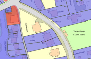
Emapsite LandPack Title and Tenure
OS MasterMap enriched with HM Land Registry Polygons, along with additional property information such as property type, construction age and EPC data.
Product DetailsEmapsite LandPack Title and Tenure provides Emapsite LandPack Polygons plus OS MasterMap Topography Layer for a customer's area of interest. The product indicates freehold and leasehold polygons and areas where no data is held (perhaps because ownership information is held in paper deeds, by a mortgage provider/solicitor or there is no owner) along with property information such as property type, built form and construction age plus current energy consumption, rating, efficiency and carbon dioxide (CO2) emissions.
There may be more than one polygon per Title (e.g. where a house with a garden has a garage located separately).
You can purchase emapsite Land Title and Tenure through our online mapshop, where you can define your area of interest and purchase in a range of GIS formats.
N.B. Shows the indicative location of a registered title.
Licence: PDF
Common uses:
Ideal for project and site specific users in a variety of sectors where land parcel information is required, including planning, site development and asset management.
Technical Details
- Supplier
- Update Cycle
- 6-weekly
- Coverage
- England and Wales
- Scale
- 1:1250
- Formats Available
- SHP, GDB, DWG
- Stated Accuracy
- Stated Accuracy
- Stated Accuracy
- Licence Options
- Annual
- Delivery Timescale
Related Products
OS MasterMap Topography Layer, AddressBase Plus
Download Samples
Emapsite LandPack Polygons
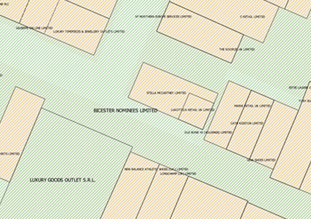
Emapsite LandPack Polygons Provides residential and commercial property ownership information for England & Wales, including HMLR ‘index’ polygon ID, geometry and title descriptor and current energy performance.
Product DetailsLandpack Polygons shows the indicative shape and position of each boundary of a HMLR registered title for land and property in England and Wales, mapped against OS MasterMap Topography Layer (licensed separately). Every freehold or leasehold title has at least one index polygon and the polygons are held in vector format. This dataset has more than 25 million titles and 28 million polygons.
The product also includes Title Descriptor information (e.g. Estate Interest and Class of Title which describe legal interests that are recorded against freehold and leasehold estates), property information such as property type, built form and construction age plus current energy consumption, rating, efficiency and carbon dioxide (CO2) emissions.
The product is available as a complete dataset for England & Wales and as cut-outs for a customer's area of interest. It is supplied in SHP, DWG and GDB data formats for ingestion into a customer's geospatial system.
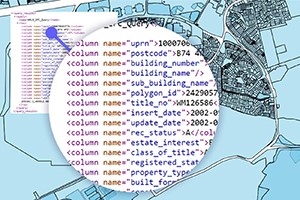
The dataset is also accessible through a Query-API returning an XML file which can be queried by postcode, postcode+building_number, postcode+building name and UPRN.
Licence: PDF
Common uses:
Ideal for project and site specific users in a variety of sectors where land parcel information is required, including planning, site development and asset management.
Technical Details
- Supplier
- Update Cycle
- 6-weekly
- Coverage
- England and Wales
- Scale
- 1:1250
- Formats Available
- SHP, GDB, DWG.
- Stated Accuracy
- Stated Accuracy
- Stated Accuracy
- Licence Options
- Annual
- Delivery Timescale
Related Products
OS MasterMap Topography Layer, AddressBase Plus
Download Samples

Emapsite LandPack Commercial Ownership
Provides ownership & energy performance information for commercially owned land & property in England & Wales (including polygons), along with additional property insights & EPC data.
Product DetailsProvides ownership and energy performance information for land and/or property in England & Wales which is owned by UK and Overseas companies along with Landpack Polygons for commercially owned land/property.
The product combines information from the HMLR datasets formerly known as Commercial and Corporate Ownership data (CCOD) and Overseas Companies Ownership Data (OCOD) supplemented with property and energy performance information. Includes address, proprietor name and company registration number, proprietor type (e.g. Limited or Public Limited company, Local Government, Housing Association etc.), title and tenure along with property information such as property type, built form and construction age plus current energy consumption, rating, efficiency and carbon dioxide (CO2) emissions where appropriate. The data does not show land or property owned by private individuals, overseas companies or charities (incl. Charitable Incorporated Organisations).
Technical Details
- Supplier
- Update Cycle
- 6-weekly
- Coverage
- England and Wales
- Scale
- Formats Available
- SHP
- Stated Accuracy
- Stated Accuracy
- Stated Accuracy
- Licence Options
- Annually
- Delivery Timescale
Related Products
Download Samples
Emapsite LandPack Polygons Query API
This Query-API service enables customers to query the Emapsite LandPack Polygons dataset of HM Land Registry (HMLR) polygons supplemented with title ownership and energy performance information for England & Wales.
Product DetailsInstead of hosting and managing the Emapsite Landpack Polygons dataset, customers can integrate their applications directly with the dataset managed and maintained by Emapsite. The API information is used by an application developer to integrate with a customer's software application, so that the application can 'call' the dataset when required (e.g. at the point of lookup).
The Query API enables customers to focus on their business activities and not worry about managing nor maintaining a geospatial dataset. Customers will be able to implement internal business activities more quickly and obtain the information they need for increased confidence, speed, accuracy and convenience.
Query-APIs are transaction-based services with an annual allowance of queries ('calls'), allocated equally across the licence period. The tariff is agreed upfront based on expected usage.

HMLR Title Registers with Polygon
Provides HM Land Registry Title Register document and data, including Title Plan area geometry.
Product DetailsHMLR Title Register with Polygon is a bundle containing an ‘official copy’ of a HM Land Registry Title Register (PDF document) together with an XML file containing data extracted from the Register plus a CSV file containing the unique property reference number (UPRN) and the Title Plan geometry to aid data visualisation and analysis.
HM Land Registry (HMLR) Title Registers are the official records of land and property ownership in England & Wales. They describe who owns land a property, the type of ownership (freehold, leasehold) and any restrictions or charges affecting the land.
Up to 20 Title Register documents may be ordered by defining an area of interest in the Emapsite mapshop or any number of Title Registers by submitting an email list of addresses, unique property reference numbers (UPRN) or Title-IDs through Customer Services.
This product is intended for research and analysis activities in land and property use cases. Title Registers are updated by HM Land Registry continuously and data supplied is that available at the time of order fulfilment. Once order fulfilment commences, cancelled orders cannot be refunded.
Technical Details
- Supplier
- HM Land Registry
- Update Cycle
- Updated via new Order
- Coverage
- England & Wales
- Scale
- Formats Available
- Bundle containing PDF, XML and CSV files.
- Stated Accuracy
- Definitive/Authoritative from HM Land Registry
- Stated Accuracy
- Stated Accuracy
- Licence Options
- Perpetual
- Delivery Timescale
- Next Day
Related Products
Download Samples