We are here to help
Need us to answer something specific, get in touch with us directly.
Need us to answer something specific, get in touch with us directly.
A. Military Practice Areas’ are listed in the Marine Themes Administrative layer.
A. Raster charts are digitised versions of familiar nautical charts, these are images used for base/background mapping. Marine themes, derived from Electronic Navigational charts (ENC) plus other data, are made up of vector data, this is available in individual layers grouped by feature type, these layers can switched on and off, and in GIS you can also query features and attributes, and build constraints models.
A. For convenience, we have grouped charts of a similar scale level into bands corresponding to the following levels:
Small: Chart scales of less than 1: 150,000
Medium: Chart scales of equal to or greater than 1:150,000, and less than 1: 30,000
Large: Chart scales equal to or greater than 1: 30,000.
A. Marine data is created by various Hydrographic offices globally, the licence availability and detail of data, will vary between them, please enquire for availability and cost.
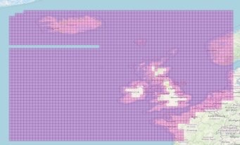
A. This is our principal coverage for Marine Themes as of November 2023:

We can search outside of this coverage map for you to find availability and where it exists, provide a quote.
A. Marine themes data can be created upon request, providing the Hydrographic office who have control of the data are happy licenced it to be used in this way, please enquire with a shp file or AOI for cost and delivery time.
A. Charts are mostly standardised to the WGS84 Datum, especially in UK waters, and are projected either to Mercator or Transverse Mercator. The files containing these charts, and any that are referenced to a different system, include appropriate georeference metadata which is available to the user or system to ensure accurate positioning in GIS. All depths and drying heights are referenced to Chart Datum, which approximates to Lowest Astronomical Tide (LAT).
A. Charts are symbolised to the international standard known as INT1. If you are unfamiliar with this standard or you require further information, details are contained in the publication ‘Symbols and Abbreviations Used on Admiralty Charts 5011’ available from the UK Hydrographic Office.
A. Metadata is presently not supplied with the Raster Charts Product, due to copyright. If you would like tide information etc please see Marine Themes data.
A. The Raster Charts Product is supplied in the GeoTIFF format. Themes is available in SHP file. Both are read by GIS software.
If you would like Emapsite to provide Marine data in other formats, we would love to hear from you. Please contact us at customersupport@emapsite.com and we will see what we can do!
