
OS MasterMap Topography Layer
Buy Ordnance Survey OS MasterMap Topography Layer® with expert support from Emapsite.
Download highly detailed mapping of Great Britain’s landscape for use in planning applications, infrastructure design, land analysis and asset management.
With Emapsite, building height data and bespoke export formats are included at no additional cost, helping you get the mapping you need quickly.
Get highly accurate mapping of real-world features including:
- • Buildings and building outlines
- • Roads and transport features
- • Land parcels and boundaries
- • Water features and vegetation
- • Paths, fences and street-level detail
OS MasterMap is used by planning consultants, developers, engineers, utilities companies and public sector organisations.
OS MasterMap Topography Layer® is trusted by everyone. Available in a variety of formats including DWG extracts, ideal for CAD and planning and risk management. It can also be streamed as a webservice. OS MasterMap® is the approved dataset for planning applications and land registration.

About OS MasterMap Topography Layer
Ready to download in minutes, Ordnance Survey MasterMap Topography Layer® is the most detailed mapping and accurate view of Great Britain's landscape – from roads to fields, to buildings and trees, fences, paths and more.
OS MasterMap Topography Layer® is the Ordnance Survey's most detailed, current and comprehensive map dataset of Great Britain, enabling you to make better decisions and manage your assets more effectively. Working alongside other Ordnance Survey datasets, OS MasterMap Topography Layer® gives you the visual context to help interpret addresses, routes and imagery.
Continually updated, it contains 450 million geographic features found in the real world, from detailed building and road outlines to water features, pathways, bus shelters and letter boxes.
This level of detail allows organisations to:
- • Analyse land and site characteristics
- • Design infrastructure and development layouts
- • Manage physical assets
- • Assess environmental and planning constraints
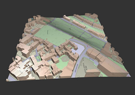
And at Emapsite, we don't charge extra to have the building height data. It's included as standard.
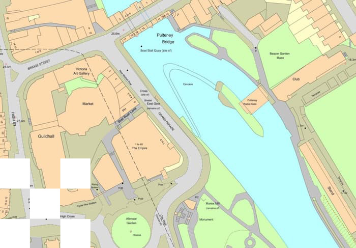
OS MasterMap with Building Heights data, overlaid OS Terrain 5 height data (not included):

Who Uses OS MasterMap Topography Layer?
OS MasterMap Topography Layer® is widely used by:
- • Planning consultants and architects
- • Property developers and land agents
- • Engineering and infrastructure consultancies
- • Utilities and telecom providers
- • Local authorities and government organisations
Download Sample Data
Example data extracts are available in a range of CAD, GIS and PDF formats.
CAD Formats:
DWG Standard, DWG Standard + Grid, DWG Colour Plan, DWG Building Heights, DXF, DGN
GIS Formats:
PDF Mapping:
PDF at 1:1,250 Scale 4ha in Colour (A4): PDF
OS MasterMap Topography layer is ideal for:
-
• GIS and CAD mapping workflows
-
• Planning applications and site location plans
-
• Site evaluation and feasibility studies
-
• Risk and environmental analysis
-
• Transport and infrastructure design
-
• Asset management and land referencing
OS MasterMap Topography Layer
The most detailed and accurate view of Great Britain's landscape with 1:1250 scale mapping for GIS/CAD and with building heights included at no extra charge.
Product DetailsOS MasterMap Topography Layer ® is a comprehensive large-scale map of Great Britain containing over 500 million features. It details man-made and natural features such as buildings, fields, fences, bodies of water and letter boxes (and intangible objects, such as county boundaries and the lines of mean high or low water). OS MasterMap is surveyed at 1:1,250 in urban areas, 1:2,500 in rural areas and 1:10,000 in moorland areas with coverage of the whole of Great Britain.
Continually updated, OSMM Topo works seamlessly with other datasets to enable analysis and inform decision making. It provides the visual context to help interpret addresses, plan vehicle routing and scheduling and is the approved dataset for planning applications, land registration and many other applications.
OS MasterMap Topography Layer® is ideal for:
- Planning
- Environmental analysis
- Solar & wind farm locations
- Site identification, acquisition, design, and build
- Investment & Insurance risk management
- Asset management
- Transport scheduling
- And many more...
Technical Details
- Supplier
- Ordnance Survey
- Update Cycle
- 6 weekly
- Coverage
- GB
- Scale
- 1:1250
- Formats Available
- DWG, SHP, GML, TAB, DXF, GDB, KML, TIFF
- Stated Accuracy
- Urban +/- 1m
- Stated Accuracy
- Rural +/- 8m
- Stated Accuracy
- +/- 8m
- Licence Options
- 12, 24 or 36 months
- Delivery Timescale
- Within minutes
Related Products
OS Mastermap Imagery Layer , PDF Plans
Complementary Data
AddressBase Plus , OS Mastermap Highways Layer , Lidar
Download Samples
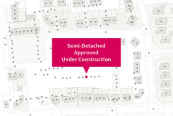
OS MasterMap Highways Network
OS MasterMap Highways Network® provides an authoritative view of the whole road network in Great Britain, ideal for routing and public sector data-sharing.
Product DetailsOS Mastermap Highways Network® is the Ordnance Survey's latest and most comprehensive dataset of Great Britain's road network and is the next generation of the well-known product OS ITN. It is comprised of a suite of products that brings together the best information from authoritative sources in to one central location.
In addition to road centre lines and classifications, Highways features richer content that is better structured to allow for analysis as well as visualisation. Highways has been designed with traffic analysis, asset management, planning and the emergency services in mind, allowing users to plan for tomorrow. It gives you accurate and precise asset management information on who maintains the road network and the type of surface reinstatement values. And it's a valuable reporting tool, for key facts and statistics about the road, against a consistent and authoritative base.
OS Highways - Roads can be extended using OS Highways - Routing, and OS Highways - Paths
OS Highways - Roads attribution includes:
- road classification, naming and numbering
- vehicle restrictions
- links to OS Addressbase and the USRN
- roads under construction
- public/private maintained roads
- special engineering difficulty
- special event information
- road hazards: overhead structures, level crossings, movable bollards, gates
- protected streets
- traffic sensitive roads
OS Highways - Routing additionally includes:
- turn restrictions
OS Highways - Paths additionally includes:
- links between roads/paths
Technical Details
- Supplier
- Ordnance Survey
- Update Cycle
- Coverage
- GB
- Scale
- 1:1250
- Formats Available
- Stated Accuracy
- Stated Accuracy
- Stated Accuracy
- Licence Options
- Delivery Timescale
Related Products
PDF Plans, Aerial Photography
Complementary Data
OS Mastermap Imagery Layer, Lidar, AddressBase Plus
Download Samples
OS MasterMap Highways Network - Roads: SHP, GML, DWG
OS MasterMap Highways Network - Routing and Asset Management: SHP
OS MasterMap Highways Network - Paths: SHP, GML
Buy OS MasterMap Highways Network - Roads >
Buy OS MasterMap Highways Network - Roads and Asset Management >
AddressBase Premium
Highly detailed address dataset for GB with 40 million addresses.
Product DetailsCombining National Land and Property Gazetteer (NLPG) and Royal Mail Postcode Address File (PAF), for the full lifecycle of an address.
AddressBase Premium provides the most detailed view of an address and its life cycle for England, Wales and Scotland. The product contains approximately 40 million addresses, each with UPRN unique identifier. Includes alternative addresses (e.g. where a property known as Rose Cottage is also 23 Acacia Avenue), provisional addresses (proposed planning developments), historic addresses (demolished properties) and objects without a postal address (e.g. places of worship, community centres and utilities).
The new Address products have been produced by GeoPlace, a joint venture between Ordnance Survey and the Local Government Group.
The AddressBase™ Premium product includes the best parts of local government’s National Land and Property Gazetteer (NLPG), Ordnance Survey’s OS MasterMap Address Layer 2 and the Royal Mail Postcode Address File (PAF), plus comprehensive address classification details.
AddressBase™ Premium is the most comprehensive product in the range and is an entirely new concept in the world of addressing for GB. AddressBase™ Premium is a relational database detailing the whole lifecycle of an address from pre-build through completion and successive name changes of businesses. Suitable for use in interrogating for bespoke services, Emapsite can provide access to this valuable dataset through our web services delivery solutions. Please call us for more details.
Technical Details
- Supplier
- Ordnance Survey
- Update Cycle
- 6-weekly
- Coverage
- GB
- Scale
- 1:1250 to 1:10,000
- Formats Available
- CSV, GML
- Stated Accuracy
- Stated Accuracy
- Stated Accuracy
- Sub-metre
- Licence Options
- Annual
- Delivery Timescale
- Within minutes
Related Products
Complementary Data
OS Mastermap Highways Layer, OS Mastermap Imagery Layer
Download Samples
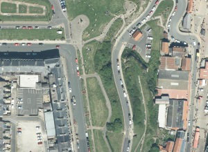
OS MasterMap Imagery Layer
The OS MasterMap Imagery Layer® comprises the best available aerial images, edge-matched and orthorectified to align with other OS MasterMap layers.
Product DetailsThe aerial images give added context to features which exist within other (vector) OS MasterMap layers and allow interpretation of other features not identified within the vector datasets. The data is rigorously checked for quality to maintain a consistent standard of both positional accuracy and image quality.
Additionally Ordnance Survey processing software produces true-orthorectified imagery, removing building lean from aerial imagery to give you a consistent top-down view.
Aerial imagery is ideal for checking road markings, tree canopies or site entrances, cutting down the need for site visits, so you can save money and manage time more efficiently.
Purchasable as both a traditional raster cut-out of a user defined area or as web services.
OS MasterMap Imagery layer® is ideal for:
- Planning
- Site location and evaluation
- Land use classification and analysis
- Transport and infrastructure
- Asset management
- Environmental analysis
- Flood mapping
- 3D visualisation
.
Technical Details
- Supplier
- Ordnance Survey
- Update Cycle
- Quarterly
- Coverage
- GB
- Scale
- 25cm resolution
- Formats Available
- Stated Accuracy
- Stated Accuracy
- Stated Accuracy
- Licence Options
- Delivery Timescale
Related Products
OS MasterMap Topography Layer, OS Mastermap Imagery Layer, Lidar, AddressBase Plus
Download Samples
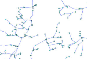
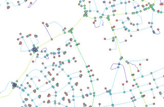
OS MasterMap Networks - Water Layer
The OS MasterMap Networks - Water Layer® is a detailed, accurate and up-to-date vector dataset of Great Britain’s water network - rivers, streams, lakes and canals.
Product detailsThe OS MasterMap Networks - Water Layer® is the only detailed, heighted water network of Great Britain showing the flow and precise course of rivers, streams, lakes and canals.
It offers the most accurate view of all watercourses across the whole of Great Britain created, in collaboration with the Environment Agency and Scottish Environmental Protection Agency, to a consistent specification and update schedule – so it can help support flood risk management decisions and the sharing of information between national and local organisations.
Accurate physical properties of watercourses enable modelling in 2D and 3D like never before, thanks to the clear and detailed information about river flow, gradient and river widths, along with its precisely mapped course.
The data maps a wide range of features, from aqueducts to tunnels with full flow direction and for the first time the network of underground watercourses – inferred from the entry and exit points.
OS MasterMap Networks - Water layer® is ideal for:
Planners, for surveyors, for engineers – this Layer offers the potential to model in 2D and 3D like never before, thanks to the clarity of river flow, gradient and river widths.
Technical Details
- Supplier
- Ordnance Survey
- Update Cycle
- Coverage
- GB
- Scale
- 1:1250
- Formats Available
- DWG, SHP, GML, TAB, DXF, GDB, KML, TIFF
- Stated Accuracy
- Urban +/- 1m
- Stated Accuracy
- Rural +/- 8m
- Stated Accuracy
- +/- 8m
- Licence Options
- 12, 24 or 36 months
- Delivery Timescale
- Within minutes
Related Products
OS Mastermap Topography Layer, Aerial Photography, OS Mastermap Imagery Layer, Lidar
Download Samples
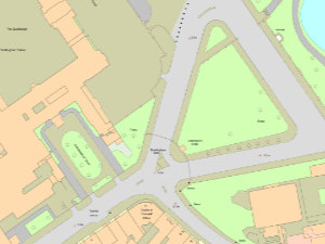
OS MasterMap NON-GEO
Image version of OS MasterMap Topography Layer for use in document illustration.
Product detailsOS MasterMap NON-GEO provides an image of the most detailed and accurate view of Great Britain's landscape without geo-reference information. Shows man-made and natural features such as buildings, fields, fences, bodies of water and objects such as letter boxes (plus intangible objects, such as county boundaries and the lines of mean high or low water).
Suitable for map illustration in display and printing applications at map scales between 1:500 and 1:5 000.
Available for bespoke areas-of interest and with a maximum orderable area of 100 hectares (1km2).
Ideal for use in:
- Word processing and graphic design applications.
- Map illustrations in brochures and guides, site location/evaluation reports and risk management reports.
Technical Details
- Supplier
- Ordnance Survey
- Update Cycle
- Every 6 weeks
- Coverage
- GB
- Scale
- 1:1250 to 1:10,000
- Formats Available
- JPG, TIF, PNG, BMP (Colour) and JPG, TIF, BMP (Black&White)
- Stated Accuracy
- Stated Accuracy
- Stated Accuracy
- Licence Options
- Annual
- Delivery Timescale
- Within minutes
Related Products
Download Samples

Unrivalled resources
We simplify the supply and management of mapping products, plans and reports. Blending diverse datasets to uncover hidden commercial insights.

Business intelligence
Our spatial intelligence enables our clients to pinpoint areas of risk and reward, and to make better business decisions faster.

Proven partnership
We work in partnership, we're supportive, and we're committed to reducing our own and our clients' impact on the environment.