
Address Services
Address matching and cleansing, geocoding, or link address data to all kinds of other information sources by using UPRN.

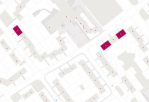
Get the most out of your address data
So many activities start with an address. Emapsite has developed a range of address services to support customers in ensuring they are able to get maximum value from their address data.
Address work?
We can match or cleanse your data against AddressBase Premium®.
Geocoding?
Ask us to look at your data and geocode the underlying information.
Competitive advantage?
We deliver location intelligence that solves unique business challenges.
Does your business have a customer database?
Connected, authoritative location data helps you to understand where you’re selling and why. It also helps you to see how to target new customers.
We can provide address matching and geocoding services that will reveal valuable, tangible insights about your business.
Ideal for:
-
- - marketers
- sales teams
- product development teams
- strategy work
- customer service teams
- service response teams.
- - marketers
Addressible. More precise location.

Addressible - for more precise routing and logistics.
Understand where customers really are, make your logistics visible. Addressible delivers the detail needed to plan routes more efficiently, reduce carbon emissions and cut fleet costs.
Addressible– for better pricing and more accurate analytics.
Insurers, retail outlets, comparison websites – link client requests to pricing databases with confidence. Reduce the area of interest, increase the accuracy of your pricing on a case by case basis.
Addressible – for improved marketing and sales campaigns.
Understand your prospects, reduce the cost of acquiring new customers with Addressible. Plan your campaign, down to individual address level – reap the benefits of granular detail.
Addressible provides detailed physical locations
Plan your service provision more accurately, price with greater confidence, minimise abandoned baskets, and make auto-fill fields more user-friendly. - Addressible delivers all the detail you need to understand exactly the location of a Royal Mail address.
Addressible - giving Royal Mail data a spatial reference
Addressible is the ideal dataset for anyone to understand location of customer addresses more precisely.

Helpdesks, customer services, insurers, and users of online webforms.
It adds all the details you need to Royal Mail address data.
Discover the Address Data we can provide
Choose from OS AddressBase® derived products, to our own Addressible data, Emapsite offers location data, direct address matching and geocoding services.
Emapsite Addressible
Links over 30 million Royal Mail addresses in Great Britain with location information.
Product DetailsLinks over 30 million Royal Mail addresses in Great Britain with location information including X/Y coordinates (British National Grid), Lat/Long coordinates, unique property reference number (UPRN) and topographical identifier (TOID). Includes address information from Royal Mail Postcode Address File (PAF), Multi-Residence File, Alias File and Welsh Language File.
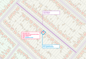
Emapsite Addressible is a GB address dataset comprising Royal Mail address information with positional informational. It is intended to be the basis of address lookup services for both internal use (e.g. customer helpdesk) and external use (e.g. webform completion) as well as managing final mile delivery services. The product contains over 30 million addresses, 1.8 million post codes and 1.4 million business names. It combines address information from Royal Mail Postcode Address File (PAF), Multi-Residence File, Alias File and Welsh Language File with location coordinates (X/Y and Lat/Long), topographical identifier (TOID) and unique property reference number (UPRN). The product joins the various files and attributes via the Royal Mail UDPRN (Unique Delivery Point Reference Number) and links all residencies at a location with a UPRN. It is supplied as a GB dataset and a sample file is available for a small area of the city and county of Swansea (Welsh: Dinas a Sir Abertawe).
Also available as an XML Query-API service.
Technical Details
- Supplier
- Emapsite
- Update Cycle
- Quarterly
- Coverage
- GB
- Scale
- Formats Available
- CSV
- Stated Accuracy
- Stated Accuracy
- Stated Accuracy
- Licence Options
- Annual
- Delivery Timescale
- Within 24 hours
Related Products
Download Samples
AddressBase
AddressBase™ address data combines local government’s National Land and Property Gazetteer (NLPG) and the Royal Mail Postcode Address File (PAF).
Product DetailsAddressBase matches 29 million Royal Mail postal address to unique property reference numbers (UPRN). The product enhances Royal Mail Postcode Address File (PAF®) attribution with X, Y coordinates and Latitude/Longitude coordinates to locate an address on a map. Provides basic classifications for simple analyses and marketing purposes.
The AddressBase™ products include the best parts of local government’s National Land and Property Gazetteer (NLPG), Ordnance Survey’s OS MasterMap Address Layer 2 and the Royal Mail Postcode Address File (PAF).
AddressBase™ is the basic product in the range and is analogous with the OS AddressPoint product which will eventually be retired. AddressBase™ is available by the square kilometre instead of by government office region.
Attributes include the Unique Delivery Reference Point Number (UDPRN), a primary classification, postcode type (Small - for residential, or Large - for larger commercial buildings) and method of calculating the x,y position, as well as all standard address details with x,y coordinates.
All addresses that have been matched by GeoPlace to Royal Mail's PAF are included; any addresses that have not been PAF matched are not included. For a fuller more complete product we recommend AddressBase plus.
Licence: PDF
Technical Details
- Supplier
- Emapsite
- Update Cycle
- Quarterly
- Coverage
- GB
- Scale
- Formats Available
- CSV
- Stated Accuracy
- Stated Accuracy
- Stated Accuracy
- Sub-metre
- Licence Options
- Annual
- Delivery Timescale
- Within minutes
Related Products
Download Samples

AddressBase Premium
Highly detailed address dataset for GB with 40 million addresses.
Product DetailsCombining National Land and Property Gazetteer (NLPG) and Royal Mail Postcode Address File (PAF), for the full lifecycle of an address.
AddressBase Premium provides the most detailed view of an address and its life cycle for England, Wales and Scotland. The product contains approximately 40 million addresses, each with UPRN unique identifier. Includes alternative addresses (e.g. where a property known as Rose Cottage is also 23 Acacia Avenue), provisional addresses (proposed planning developments), historic addresses (demolished properties) and objects without a postal address (e.g. places of worship, community centres and utilities).
The new Address products have been produced by GeoPlace, a joint venture between Ordnance Survey and the Local Government Group.
The AddressBase™ Premium product includes the best parts of local government’s National Land and Property Gazetteer (NLPG), Ordnance Survey’s OS MasterMap Address Layer 2 and the Royal Mail Postcode Address File (PAF), plus comprehensive address classification details.
AddressBase™ Premium is the most comprehensive product in the range and is an entirely new concept in the world of addressing for GB. AddressBase™ Premium is a relational database detailing the whole lifecycle of an address from pre-build through completion and successive name changes of businesses. Suitable for use in interrogating for bespoke services, Emapsite can provide access to this valuable dataset through our web services delivery solutions. Please call us for more details.
Licence: PDF
Technical Details
- Supplier
- Ordnance Survey
- Update Cycle
- 6-weekly
- Coverage
- GB
- Scale
- Formats Available
- CSV, GML
- Stated Accuracy
- Stated Accuracy
- Stated Accuracy
- Sub-metre
- Licence Options
- Annual
- Delivery Timescale
- On request
Related Products
Download Samples
AddressBase Plus
Address data, including non postal addresses (e.g. ponds, telephone boxes).
Product DetailsAddressBase™ Plus includes National Land and Property Gazetteer (NLPG) and the Royal Mail Postcode Address File (PAF), plus extra features for address data classification.
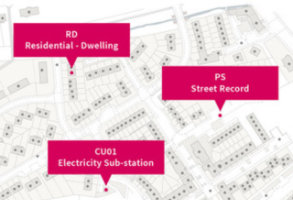
AddressBase-Plus contains all current addresses validated from Local Custodians as well as non-postal addresses such as ponds, electricity sub-stations and telephone boxes (36 million addresses). The product enables customers to locate an address or property on a map using either X, Y coordinates (British National Grid) or Latitude, Longitude coordinates (ETRS89 projection), and display the Local Authority or Royal Mail address elements where matched.
The Address products have been produced by GeoPlace, a joint venture between Ordnance Survey and the Local Government Group.
The AddressBase™ Plus product includes the best parts of local government’s National Land and Property Gazetteer (NLPG) and the Royal Mail Postcode Address File (PAF), plus extra features for address classification.
AddressBase™ Plus is the richer product in the range and is analogous with the legacy OS AddressLayer 2 product. Attributes include the Unique Property Reference Number (UPRN), Unique Delivery Reference Point Number (UDPRN), four levels of classification for the type of address, method of calculating the x,y position, as well as all standard address details with x,y coordinates. Additional language options for addresses are also provided, along with the local authority and parish code, VOA codes, non-addressable objects such as churches and community centres, and multiple occupancy property information. All these additional attributes are not available within the standard basic AddressBase product, therefore we recommend AddressBase Plus for the majority of commercial and professional uses.
Licence: PDF
Technical Details
- Supplier
- Ordnance Survey
- Update Cycle
- 6 weekly
- Coverage
- GB
- Scale
- Formats Available
- CSV, SHP, GML
- Stated Accuracy
- Stated Accuracy
- Stated Accuracy
- Sub-metre
- Licence Options
- Annual
- Delivery Timescale
- Within minutes
Related Products
Download Samples
AddressBase Core
The definitive source of address and property information.
Product DetailsLocal Authority data is at the heart of AddressBase Core. Providing you with a complete address data product & ensuring access to granular detail when compared to the alternative - delivery points.
AddressBase Core takes many of the important elements from the other AddressBase products, such as coordinates, classification and cross-references to connect address information to other products via key identifiers. Address information is provided in an easy-to-use format alongside a single line attribute which concatenates all the address elements into what you would expect to see on an envelope. Available as CSV and GeoPackage file format.
AddressBase Core makes it easier to locate, match and gain insights from other location data with the benefit of having key identifiers referenced throughout. The Unique Property Reference Number (UPRN), Unique Street Reference Number (USRN) and Topographic Identifier (TOID) allow users to reference to other OS products.
Third party identifiers such as the Unique Delivery Point Reference Number (UDPRN) and Government Statistical Service (GSS) Code are also included, so you're more likely to be able to confidently bring multiple sources together using one of the key identifiers included in this dataset.
Making the most of the property classification attributes, you can quickly understand, locate and perform analysis on the type of addresses you want to interact with.
You don’t need to use it all - only need residential addresses, commercial addresses or even just schools? No problem - AddressBase Core can do that too!
Licence: PDF
Technical Details
- Supplier
- Ordnance Survey
- Update Cycle
- Fortnightly
- Coverage
- Great Britain
- Scale
- 1:10 – 1:10 000
- Formats Available
- Comma separated value (CSV) or SHP
- Stated Accuracy
- Stated Accuracy
- Stated Accuracy
- Sub-metre
- Licence Options
- Annual
- Delivery Timescale
- Within minutes
Related Products
Download Samples
AddressBase Islands
Address data for the British Isles outside of GB, covering Northern Ireland, Isle of Man and the Channel Islands, complete with AddressBase-compatible UPRNs.
Product DetailsAddressBase™ Islands takes addressing data for Northern Ireland, the Isle of Man and the Channel Islands and applies the AddressBase™ product schema to the data, allowing the use of the Unique Property Reference Number (UPRN) and similar classifications across the whole geographic area.
AddresBase Islands is available for customers who have already licensed AddressBase Plus or AddressBase Premium for areas of GB.
Licence: PDF
Technical Details
- Supplier
- Ordnance Survey
- Update Cycle
- Coverage
- NI, Isle of Man, Channel Islands
- Scale
- Formats Available
- CSV, GML
- Stated Accuracy
- Stated Accuracy
- Stated Accuracy
- Licence Options
- Annual
- Delivery Timescale
- On request
Related Products
Download Samples