Mapping for Architects
Emapsite works daily with thousands of Architects.
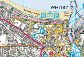
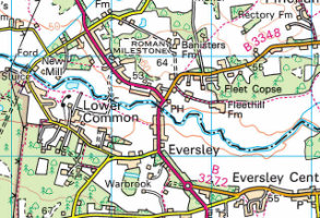
For most Architects it's all about OS MasterMap, the most detailed view of Great Britain. Emapsite offer multiple formats and enhancements for OS MasterMap, straight from our Mapshop.

Why do architects choose us?

By choosing us you can leverage our commercial experience and knowledge. As strategic partners of the Ordnance survey (OS) we will continue to innovate based on what you want.
We offer MasterMap in multiple formats, together with other data like Terrain, Aerial Imagery, Flood data and Reports, Historical mapping and Land Use, and underground utility data. Our team is always on hand to provide customer support and helpful advice from geospatial experts to help you get the most from our service.
Our cross-sector experience lets us bring innovation and insight to our products development, which in turn delivers user-friendly, insightful products for you and your clients.
• Easy to use self-service Mapshop, small area purchases, multiple CAD formats.
• OS MasterMap enhanced with land ownership boundaries, free building height data.
• No MasterMap viewing charges, pay-as-you-go, no monthly costs, competitive prices.
• 30 day refund policy*. Free reprocessing to get the latest map version.
• Access to mapping for Local Authority clients under their PSGA licence.

Mapping to support design
We offer multiple formats, and enhancements, for OS MasterMap, straight from our Mapshop.
OS MasterMap
Free to view; simply select your site without incurring charges. Choose your preferred format's, including ready made PDF planning formats, and download in minutes.
Our system remembers your preferences and will show you those for future purchases. For example, if you like free building heights, you can set this as a default. Finally, we don’t charge any extra for multiple formats.
OS MasterMap 3D
Valued by landscape architects, OS MasterMap 3D is MasterMap combined with OS Terrain 5 as a single file, saving time and money. Perfect for affordable 3D rendering for context.
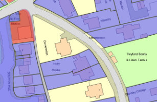
OS MasterMap LandPack Land Title and Tenure
For larger projects, or projects where your client’s boundary needs qualifying, our MasterMap LandPack Land Title and Tenure is perfect. LandPack Land Title and Tenure overlays the Land Registry polygon onto MasterMap.
Other Mapping and Information
Our Mapshop offers the full suite of OS background mapping including 1:25,000, 1:50,000 and Terrain data. Increasingly Architects are approaching Emapsite for extra data or where extra information can help with planning challenges.
Aerial Imagery
Choose and compare imagery from 3 suppliers in one place. You can access imagery from 12.cm to 5M resolution with varying capture dates, enabling you to get what is most appropriate for that particular scheme.
Historical mapping/Historical Land use
Choose from a range of historical mapping and historic land use. A range of digitised maps are available from 1805 onwards, with large scale mapping from 1:2500 scale. These maps can give insight into historic hedgerows or land use.
Flood Data and Reports
We have a full range of reports covering flood, environmental and geological information, and if you aren’t sure what you need, we will always be happy to advise and send samples for you to evaluate.
OS MasterMap Topography Layer
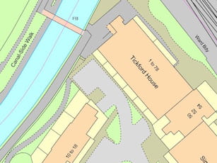
OS MasterMap Topography Layer is the most detailed and accurate view of Great Britain's landscape – from roads to fields, to buildings and trees, fences, paths and more.
Product DetailsOS MasterMap is the most detailed, current and comprehensive map dataset of Great Britain, enabling you to make better decisions and manage your assets more effectively. Working with the other mapping layers in the suite, OS MasterMap Topography Layer gives you the visual context to help interpret addresses, routes and imagery. OS MasterMap is the approved dataset for planning applications and land registration.
Continually updated, OS MasterMap contains 450 million geographic features found in the real world, from detailed building and road outlines to water features, pathways, bus shelters and letter boxes.
Licence: PDF
OS MasterMap is ideal for:
- Use in CAD or GIS
- Planning
- Site location and evaluation
- Risk management
- Transport and infrastructure
- Asset management
- Environmental analysis
Technical Details
- Supplier
- Ordnance Survey
- Update Cycle
- 6 weekly
- Coverage
- GB
- Scale
- 1:1250
- Formats Available
- DWG, SHP, GML, TAB, DXF, GDB, KML, TIFF
- Stated Accuracy
- Urban +/- 1m
- Stated Accuracy
- Rural +/- 8m
- Stated Accuracy
- +/- 8m
- Licence Options
- 12, 24 or 36 months
- Delivery Timescale
- Within minutes
Related Products
PDF Plans, Aerial Photography, OS MasterMap Highways Layer, OS Mastermap ITN, OS Mastermap Imagery Layer, Lidar, AddressBase Plus
Download Samples
OS MasterMap Imagery Layer
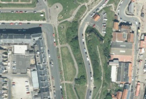
The OS MasterMap Imagery Layer comprises the best available aerial images, edge-matched and orthorectified to align with other OS MasterMap layers.
Product DetailsThe aerial images give added context to features which exist within other (vector) OS MasterMap layers and allow interpretation of other features not identified within the vector datasets. The data is rigorously checked for quality to maintain a consistent standard of both positional accuracy and image quality.
Additionally Ordnance Survey processing software produces true-orthorectified imagery, removing building lean from aerial imagery to give you a consistent top-down view.
Aerial imagery is ideal for checking road markings, tree canopies or site entrances, cutting down the need for site visits, so you can save money and manage time more efficiently.
Purchasable as both a traditional raster cut-out of a user defined area or as web services.
OS MasterMap Imagery layer is ideal for:
- Planning
- Site location and evaluation
- Land use classification and analysis
- Transport and infrastructure
- Asset management
- Environmental analysis
- Flood mapping
- 3D visualisation
.
Technical Details
- Supplier
- Ordnance Survey
- Update Cycle
- Quarterly
- Coverage
- GB
- Scale
- 25cm resolution
- Formats Available
- TIFF, JPG, PNG, BMP
- Licence Options
- Perpetual or Annual
- Delivery Timescale
- Within minutes
Related Products
Download Samples
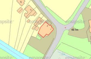
OS MasterMap PDF Location Plan
A plan at 1:1250 scale in PDF format tailored for submitting to your local authority for a range of planning applications
More info >All Location Plans come complete with a north arrow and scale bar automatically. Your plan is free to edit after purchase.
Location Plans are processed automatically and a PDF plan is emailed within minutes.
Unusually large plans are made available to download, which also typically takes just a few minutes.
Location Plan PDFs are ready to send to your local authority electronically and ready to print.
Licence: PDF
Technical Details
- Supplier
- Ordnance Survey
- Update Cycle
- 6 weekly
- Coverage
- GB
- Scale
- 1:1250
- Formats Available
- PDF, PNG
- Licence Options
- Perpetual
- Delivery Timescale
- Within minutes
Related Products
OS MasterMap Topography Layer, Aerial Photography
Download Samples
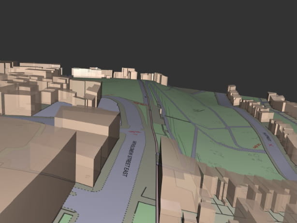
OS MasterMap 3D - Building Heights and OS Terrain 5
OS MasterMap is the most detailed & accurate view of Great Britain's landscape – with roads, fields, buildings, trees, fences & more. Combined with OS Terrain 5 as a single file, saving time & money.
Product DetailsOS MasterMap is the most detailed, current and comprehensive map dataset of Great Britain, enabling you to make better decisions and manage your assets more effectively. Working with the other mapping layers in the suite, OS MasterMap Topography Layer gives you the visual context to help interpret addresses, routes and imagery. OS MasterMap is the approved dataset for planning applications and land registration.
Continually updated, OS MasterMap contains 450 million geographic features found in the real world, from detailed building and road outlines to water features, pathways, bus shelters and letter boxes.
OS MasterMap is ideal for:
- Use in CAD or GIS
- Planning
- Site location and evaluation
- Risk management
- Transport and infrastructure
- Asset management
- Environmental analysis
OS Terrain 5 is ideal for:
OS Terrain 5 is particularly valuable for large scale development projects, planning, impact assessment
OS Terrain 5 offers detailed modelling of significant features such as road, rail, quarries and lakes allowing you to asses the lie of the land on-screen and reduce the need for site visits. OS Terrain 5 has a root mean square error (RMSE) value of 1.5 metres in urban areas and major communication routes.
OS Terrain 5 is maintained as part of the same revision process as the Ordnance Survey's large scale datasets and so adds a valuable third dimension to OS MasterMap Topography Layer.
Licence: PDF
Technical Details
- Supplier
- Ordnance Survey
- Update Cycle
- 6 weekly
- Coverage
- GB
- Scale
- 1:1250 (OS MasterMap) and 5m (Terrain 5)
- Formats Available
- DWG, SHP, PDF
- Stated Accuracy
- Urban +/- 1m (OS MasterMap)
- Stated Accuracy
- Rural +/- 8m (OS MasterMap)
- Stated Accuracy
- +/- 8m (OS MasterMap)
- Licence Options
- 12, 24 or 36 months
- Delivery Timescale
- Within minutes
Related Products
PDF Plans, Aerial Photography, OS MasterMap Highways Layer, OS Mastermap Imagery Layer, Lidar, AddressBase Plus
Download Samples
OS 1:25,000 Raster
Ordnance Survey's 1:25,000 scale mapping of GB is the digital version of OS Explorer - ideal for analysing the environment in a rural area.
Product DetailsThe Ordnance Survey's well-known Explorer series of mapping, familiar to walkers and outdoor enthusiasts. Ideal for analysing the environment across a district and in a rural areas, 1:25,000 raster data includes field boundaries, administrative boundaries, Rights of Way including access land, National Trust land, MOD land, selected cycle routes, national trails and points of interest for tourism. Contour lines are shown at 5m intervals (or 10m in some mountainous areas).
The maps can be ordered in a range of raster formats as well as the standard 10x10km TIFF tiles.
The pixel resolution of 1:25,000 data is 2.5m, and printing at 254dpi will print to the correct scale.
Licence: PDF
Technical Details
- Supplier
- Ordnance Survey
- Update Cycle
- Bi-annual
- Coverage
- GB
- Scale
- 1:25,000
- Formats Available
- TIFF, BMP, JPG, PNG
- Licence Options
- Annual
- Delivery Timescale
- Within minutes
Related Products
OS VectorMap District Raster, OS VectorMap Local, OS VectorMap Local Raster
Download Samples
OS 1:50,000 Raster
The 1:50,000 Scale Raster dataset is the digital version of the familiar Ordnance Survey Landranger® map series.
Product DetailsFamiliar to many as the OS Landranger series of paper maps, OS 1:50,000 raster data is also useful for providing context across a wide area and using as a backdrop within GIS or CAD. The maps detail roads, public rights of way, woods, water features, important buildings and contour lines at 10m intervals, and can be ordered in a range of raster formats as well as the standard 20x20km TIFF tiles.
The pixel resolution of 1:50,000 data is 5m, and printing at 254dpi will print to the correct scale.
Licence: PDF
Technical Details
- Supplier
- Ordnance Survey
- Update Cycle
- Bi-annual
- Coverage
- GB plus Isle of Man
- Scale
- 1:50,000
- Formats Available
- TIFF, BMP, JPG, PNG
- Licence Options
- Annual
- Delivery Timescale
- Within minutes
Related Products
Download Samples
Emapsite LandPack Title and Tenure
OS MasterMap enriched with HM Land Registry Polygons, along with additional property information such as property type, construction age and EPC data.
Product DetailsEmapsite LandPack Title and Tenure provides Emapsite LandPack Polygons plus OS MasterMap Topography Layer for a customer's area of interest. The product indicates freehold and leasehold polygons and areas where no data is held (perhaps because ownership information is held in paper deeds, by a mortgage provider/solicitor or there is no owner) along with property information such as property type, built form and construction age plus current energy consumption, rating, efficiency and carbon dioxide (CO2) emissions.
There may be more than one polygon per Title (e.g. where a house with a garden has a garage located separately).
You can purchase emapsite Land Title and Tenure through our online mapshop, where you can define your area of interest and purchase in a range of GIS formats.
Licence: PDF
Common uses:
Ideal for project and site specific users in a variety of sectors where land parcel information is required, including planning, site development and asset management.
Technical Details
- Update Cycle
- 6-weekly
- Coverage
- England and Wales
- Scale
- 1:1250
- Formats Available
- SHP, GDB, DWG
- Licence Options
- Annual
Related Products
OS MasterMap Topography Layer, AddressBase Plus
Download Samples

Groundsure Map Insight
The highest quality historic mapping on the market, setting a new standard in clarity and interpretability for the environmental professional.
Product DetailsMapinsight Packs are made up of A3 extracts of all available superseded Ordnance Survey maps (from the scales and maps as available to Groundsure from the copyright library used to scan the material) at a variety of scales (including 1:10000, 1:10560, 1:2500, 1:1250) supplied in PDF.
These map packs give the user an historical review of mapping back to around 1840. With full colour scans of source material at 500dpi and PDF output at 600dpi these map packs set a new standard in quality, clarity and interpretability for the environmental professional.
1:10 000 / 1:10 560 scale - there are typically 7 editions for any area
1:2500 / 1:1250 scale - typically 6 editions for any area
Urban areas are more frequently covered; 1:1250 scale only available for "urban" areas. Areas of greater population and change tend to have more mapping editions.
Technical Details
- Supplier
- GroundSure
- Coverage
- GB
- Scale
- 1:2,500 and 1:10,000
- Formats Available
- Licence Options
- Perpetual
- Delivery Timescale
- 4 working hours
Related Products
PDF Plans, OS MasterMap Topography Layer
Download Samples

Groundsure Enviro Insight
Detailed, accurate and extensive - covering environmental permits, contaminative processes and registers, waste, hydrogeology and geology.
Product DetailsThe Enviro Insight accesses Groundsure’s unique Historic Land Use Database (HLUD) which features the most accurate and reliable information available on the market. Our HLUD is derived from historic Ordnance Survey mapping dating back to the 1840s, features over 7000 land use classifications and is scanned in at over 500dpi – setting a new industry standard.
Enviro Insight offers environmental professionals condensed data in an easy to use report format combined with aerial photographs. This enables quick identification of potential risks helping to give an immediate site overview. It features current aerial photographs, an advanced graphical representation of each data element and data specific radial searches.
Enviro Insight includes:
- A clear summary that highlights key features of the report
- Aggregated historic land use information
- Detailed flood mapping from EA & Ambiental
- Enhanced planning and development designations
- Pollution inventory data
- Waste exemptions
Report is available for England, Wales and Scotland. Data sources may differ in Scotland.
Technical Details
- Supplier
- Groundsure
- Coverage
- England and Wales
- Scale
- 1:10,000
- Formats Available
- Licence Options
- Perpetual
- Delivery Timescale
- 4 working hours
Related Products
PDF Plans, OS MasterMap Topography Layer
Download Samples

Unrivalled resources
We simplify the supply and management of mapping products, plans and reports. Blending diverse datasets to uncover hidden commercial insights.

Business intelligence
Our spatial intelligence enables our clients to pinpoint areas of risk and reward, and to make better business decisions faster.

Proven partnership
We work in partnership, we're supportive, and we're committed to reducing our own and our clients' impact on the environment.