
Base Mapping
Background mapping for Great Britain and Northern Ireland in vector or raster form, for use in Geographic Information System software (GIS) and Computer-Aided Design (CAD) systems. Available at various scales and data formats for bespoke, user-defined areas of interest to suit all budgets.
Reliable base maps provide the spatial context necessary for informed decision making. Base mapping displays real-world features such as buildings, roads, railways, open areas, rivers, and more for overlaying business data and visualising solution options to business problems.
Explore the full range of mapping
Choose the level of detail that best suits the use case:
The definitive map of Great Britain
- • OS MasterMap Topography Layer® - from urban property-level detail to rural moorland mapping
Premium high-quality mapping of Great Britain, for visualisation/analysis:
- • OS VectorMap Local® - premium street-level mapping in vector or raster formats
- • OS 1:25,000 Raster - digital equivalent of OS Explorer® walking maps
- • OS 1:50,000 Raster - digital equivalent of OS Landranger® route planning maps
Generalised mapping of Great Britain, for backdrop and context:
- • OS OpenMap Local - simplified street-level mapping.
- • OS VectorMap District - simplified district-level mapping.
- • OS 1:250,000 Scale Colour Raster - regional-level mapping
- • OS MiniScale - national-level backdrop map of Great Britain.
Northern Ireland Mapping
All types and scales of mapping available and described here
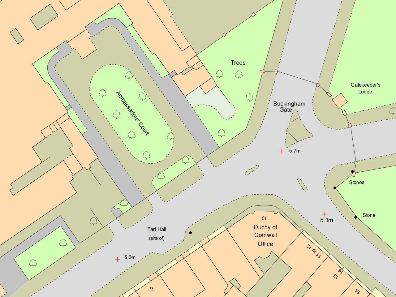
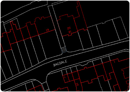
OS MasterMap Topography Layer
The definitive map of Great Britain's landscape for GIS/CAD and with building heights included at no extra charge.
View Product DetailsOS MasterMap Topography Layer is the definitive, detailed vector map of Great Britain. It provides the most detailed and accurate view of the landscape for both manmade and natural environments.
It contains over 500 million point, line or polygon features in nine themes detailing buildings, roads, tracks, paths, railways, fields, fences, and bodies of water as well as intangible objects such as administrative boundaries and the lines of mean high or low water. Each feature has a unique topographic identifier (TOID) to facilitate data sharing, plus version and version date for change management and life-cycle purposes.
OS MasterMap Topography Layer supports analytical and visualisation use cases in all industry sectors. It is mandated in Government applications and is used extensively by businesses and organisations to capture asset information for situational awareness, scenario planning and predictive modelling. It provides visual clarity for interpretation of data underpinning business decisions about assets, property boundaries and building footprints, environmental hazards, customer/operational management, route planning and logistics, site development and construction and emergency response to name a few.
OS MasterMap Topography Layer is aligned to British National Grid (EPSG:27700) with a viewing range from 1:500 scale in urban areas to 1:10 000 in rural/moorland areas depending on use case. It is supplied for bespoke areas of interest starting from a single hectare (100mx100m) and is updated every six weeks for contract customers either as 'full supply' or 'change only update - CoU' files.
Buy OS MasterMap Topography Layer
Licence: PDF
Technical Details
- Supplier
- Ordnance Survey
- Update Cycle
- Every 6 Weeks
- Coverage
- GB
- Scale
- 1:1250 to 1:10 000
- Formats Available
- SHP, GDB, GPKG, TAB, GML, DWG, DXF, TIF
- Stated Accuracy
- 1:1250
- Stated Accuracy
- 1:2500
- Stated Accuracy
- 1:10 000
- Licence Options
- Annual
- Delivery Timescale
- Within minutes
Related Products
Download Samples
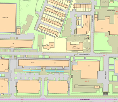
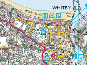
OS VectorMap Local
Detailed, street-level customisable mapping of Great Britain at 1:10 000 scale supplied for bespoke areas of interest and in whole 5km x 5km national grid tiles.
View Product DetailsOS VectorMap Local provides street-level mapping of GB. It contains points, lines and polygons representing real-world objects including buildings, roads, railways, vegetation, rivers/land areas and urban extents plus administrative boundaries, cartographic text/symbols and contours (at 5m and 25m intervals).
OS VectorMap supports analysis of real-world features for site identification and acquisition use cases, detailed building assessment for investment and environmental purposes (e.g. proximity of natural and man-made risks), basic road routing and backdrop web-mapping. In Insurance settings, OS VectorMap Local helps underwriters assess risk by processing flood and other peril models to provide rating factors for use in pricing models.
OS VectorMap Local is aligned to British National Grid (EPSG:27700) with a recommended viewing range between 1:3,000-1:20,000 (nominally 1:10,000). It is available in vector and raster forms for bespoke areas of interest and whole 5kmx5km national grid tiles. The non-geographic form is available for bespoke areas of interest only. The vector product can be styled to customer preference.
Buy VML Vector - Bespoke Areas of Interest
Buy VML Vector - 5km x 5km National Grid Tiles
Buy VML Raster - Bespoke Areas of Interest
Buy VML Raster Tiles - 5km x 5km National Grid Tiles
Buy VML Non Geographic Raster - Bespoke Areas of Interest
Licence: PDF
Technical Details
- Supplier
- Ordnance Survey
- Update Cycle
- Quarterly
- Coverage
- GB
- Scale
- 1:10,000
- Formats Available
- SHP, GDB, GPKG, TAB, GML, DWG, DXF, JPEG, TIF, PNG
- Stated Accuracy
- Stated Accuracy
- Stated Accuracy
- Licence Options
- Annual
- Delivery Timescale
- Within minutes
Related Products
Download Samples
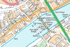
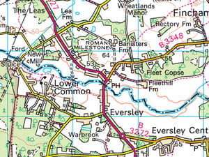
OS 1:25 000 Scale Colour Raster
The digital equivalent of OS Explorer paper map series of Great Britain supplied for bespoke areas of interest and in whole 10km x 10km national grid tiles.
View Product Details1:25 000 Scale Colour Raster provides ‘district’ level mapping of GB. It depicts the landscape with detail and clarity to provide an overview of settlements and man-made structures, transport features (from tracks and paths to airports), water features, natural features (including field boundaries, vegetation and shoreline), contours, tourist/heritage attractions, rights of way and land normally accessible on foot.
1:25 000 Scale Colour Raster is intended for use by professional/business markets. It is useful for district-level analysis and as a backdrop map for overlaying customer’s business information (e.g. environmental applications, farm/estate management, land-use planning and development, site construction/engineering and emergency response situational awareness).
1:25 000 Scale Colour Raster is aligned to British National Grid (EPSG:27700). It is available for bespoke areas of interest (to the nearest km2) and in whole 10kmx10km national grid tiles. TIFF files can be opened and annotated in software including Photoshop and InDesign and screen images can be plotted to produce a high-quality map.
Buy 1:25 000 Scale Colour Raster - Bespoke Areas of Interest
Buy 1:25 000 Scale Colour Raster - 10km x 10km National Grid Tiles
Licence: PDF
Technical Details
- Supplier
- Ordnance Survey
- Update Cycle
- Quarterly
- Coverage
- GB
- Scale
- 1:25,000
- Formats Available
- TIF, JPEG, PNG, BMP
- Stated Accuracy
- Stated Accuracy
- Stated Accuracy
- Licence Options
- Annual
- Delivery Timescale
- Within minutes
Related Products
OS VectorMap District Raster
OS VectorMap Local
OS VectorMap Local Raster
Download Samples
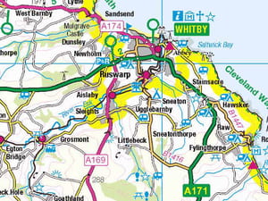
OS 1:50 000 Scale Colour Raster
The digital equivalent of OS Landranger paper map series of Great Britain supplied for bespoke areas of interest and in whole 20km x 20km national grid tiles.
View Product Details1:50 000 Scale Colour Raster provides 'regional' level mapping of GB. It provides an overview of the main features and communication routes across Great Britain and is ideal for routing/navigation use cases. It can be used in desktop, tablet and mobile applications.
1:50 000 Scale Colour Raster is intended for recreational and businesses users. It is useful for regional-level analysis and as a backdrop map for overlaying customer’s business information (e.g. environmental impact analysis, marketing analysis, land-use planning and development, vehicle routing, large-scale site construction/engineering projects and emergency response situational awareness).
1:50 000 Scale Colour Raster is aligned to British National Grid (EPSG:27700) with a viewing range from 1:20 000 to 1:60 000 scale (nominally 1:50 000). It is supplied for bespoke areas of interest (to the nearest km2) and in whole 20kmx20km national grid tiles. TIFF files can be opened and annotated in software including Photoshop and InDesign and screen images can be plotted to produce a high-quality map.
Buy 1:50 000 Scale Colour Raster - Bespoke Areas of Interest
Buy 20km x 20km National Grid Tiles
Licence: PDF
Technical Details
- Supplier
- Ordnance Survey
- Update Cycle
- Quarterly
- Coverage
- GB
- Scale
- 1:50,000
- Formats Available
- TIF, JPEG, PNG, BMP
- Stated Accuracy
- Stated Accuracy
- Stated Accuracy
- Licence Options
- Annual
- Delivery Timescale
- Within minutes
Related Products
Download Samples
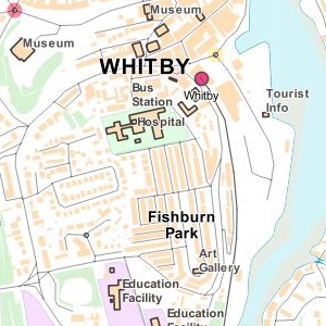
OS OpenMap Local
Simplified street-level mapping of Great Britain supplied for bespoke areas of interest.
View Product DetailsOS Open Map Local provides generalised street-level mapping for Great Britain. It displays simplified buildings, roads, electric vehicle charging stations/type and railway lines (but not sidings) plus functional sites (e.g. hospital), greenspace, place names and Department for Transport (DfT) numbers in order to facilitate alignment with other OS products.
OS Open Map Local is intended for backdrop mapping for applications or web pages. The muted colours help visualise a clear view of the country whilst enabling some analytical activities such as land use for local planning, crime location or indicating property prices.
OS Open Map Local is aligned to British National Grid (EPSG:27700) with a recommended viewing range between 1:3,000-1:20,000 (nominally 1:10,000). It is available in vector and raster forms for bespoke areas of interest.
Licence: PDF
Technical Details
- Supplier
- Ordnance Survey
- Update Cycle
- Every 6 months
- Coverage
- GB
- Scale
- 1:10,000
- Formats Available
- SHP, GDB, TAB, GML , JPEG, TIF, PNG
- Stated Accuracy
- Stated Accuracy
- Stated Accuracy
- Licence Options
- Annual
- Delivery Timescale
- Within minutes
Related Products
Download Samples
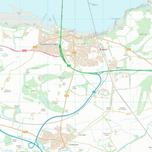
OS VectorMap District
Simplified, district-level mapping of Great Britain supplied for bespoke areas of interest.
View Product DetailsOS VectorMap District provides simplified, district-level mapping for towns and neighbourhoods in Great Britain. It displays simplified buildings, functional sites such as schools, airports (vector product only), roads, railway lines, rivers, greenspace and place names.
OS VectorMap District is intended for use as backdrop mapping for applications or web pages and is styled to complement street-level mapping such as that provided by OS VectorMap Local. It is useful for environmental and land use studies, urban/regional planning, local government service planning/management and transport/infrastructure projects.
OS VectorMap District is aligned to British National Grid (EPSG:27700) with a recommended viewing range between 1:15,000-1:30,000 (nominally 1:25,000). It is available in vector and raster forms for bespoke areas of interest. The vector form consists of layers that can be styled to suit a preferred output and to display just the required features. The raster form is pre-styled as 'backdrop' or 'full colour'.
Buy OS VectorMap District Vector
Buy OS VectorMap District Raster
Licence: PDF
Technical Details
- Supplier
- Ordnance Survey
- Update Cycle
- Every 6 months
- Coverage
- GB
- Scale
- 1:25,000
- Formats Available
- SHP, GML, TIF, JPEG, PNG, BMP
- Stated Accuracy
- Stated Accuracy
- Stated Accuracy
- Licence Options
- Annual
- Delivery Timescale
- Within minutes
Related Products
Download Samples
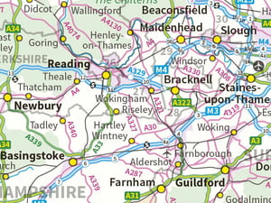
OS 1:250 000 Scale Colour Raster
Overview mapping of Great Britain, with a regional view similar to a typical road atlas.
View Product DetailsOS 1:250 000 Scale Colour Raster is a raster format map that provides a broad overview of Great Britain. It displays landscape features in a regional view similar to a typical road atlas with towns, cities, motorways, A- and B-class roads, places of interest, railways, rivers, and some woodlands.
OS 1:250 000 Scale Colour Raster is intended for use as a standalone map or regional backdrop map for route planning and navigation, tourism and outdoor recreation, education and for strategic/policy planning.
OS 1:250 000 Scale Colour Raster is aligned to British National Grid (EPSG:27700) with a recommended viewing range between 1:150 000-1:250 000 (nominally1:200 000) and is updated annually.
Buy OS 1:250 000 Scale Colour Raster - Bespoke Areas of Interest
Licence: PDF
OS Miniscale
Provides a national overview map of Great Britain.
View Product DetailsOS Miniscale is a national overview map which displays towns and cities, motorways, major roads, railways and airports and with Orkney and the Shetland Islands shown in their correct positions.
OS Miniscale is available as a vector graphic Adobe Illustrator file for publishing use cases or a raster file with georeferencing world file for use as a backdrop map in web applications and geographical information systems (e.g. a GB overview layer). It is intended to be a visually appealing location map for promotional material and website use and also finds use in high level route planning.
OS Miniscale is aligned to British National Grid (EPSG:27700) with a recommended viewing range between 1:700 000 and 1:2 000 000 (nominally1:1 000 000 i.e. 1mm = 1km) and is updated annually.
Licence: PDF
Technical Details
- Supplier
- Ordnance Survey
- Update Cycle
- Annually
- Coverage
- GB
- Scale
- 1:1 000 000
- Formats Available
- TIFF, JPEG, BMP, Adobe Illustrator
- Stated Accuracy
- Stated Accuracy
- Stated Accuracy
- Licence Options
- Annual
- Delivery Timescale
- Within minutes
Related Products
Download Samples

Unrivalled resources
We simplify data licensing, data supply and management of mapping products, plans and reports. Blending diverse datasets to uncover hidden commercial insights.

Business intelligence
Our spatial intelligence enables our clients to pinpoint areas of risk and reward, and to make better business decisions faster.

Proven partnership
We work in partnership, we're supportive, and we're committed to reducing our own and our clients' impact on the environment.