
The power of Land Cover mapping
Reliable land cover data is invaluable. At Emapsite, we provide access to trusted datasets from authoritative sources, including Ordnance Survey (OS), the UK Centre for Ecology & Hydrology (UK-CEH), Bluesky International, and more.
These premium data products offer some of the most comprehensive insights available into habitats, vegetation, land use, and surface types across Great Britain.
Use this detailed mapping to support precise environmental analysis, biodiversity assessments, land planning, and informed decision-making.
Environmental analysis and planning with Land Cover data
Land cover datasets support a wide range of environmental applications, such as Biodiversity Net Gain (BNG) compliance, habitat mapping, agricultural monitoring, and urban greenspace management.
Developed to support efficient ground-truthing, environmental planning, and analysis, we supply a broad range of datasets. These include aerial photography, digital terrain/surface models, and land ownership information from HM Land Registry.
From standard national coverage to customer-defined bespoke areas of interest, we provide optimised formats for easy integration into GIS and CAD systems.

Use Cases
Access authoritative land cover data for every use case - sourced from trusted providers and delivered by Emapsite:
-
• Biodiversity Net Gain & habitat analysis - use OS Enhanced Land Cover to map habitats, plan ecological surveys, support BNG compliance, and classify features to EUNIS or UK HAB standards.
-
• Urban & rural greenspace management - source OS MasterMap GreenSpace to assess public parks, sports facilities, and green infrastructure for flood mitigation, regeneration, and health-focused planning.
-
• Agriculture & environmental impact - use UK-CEH Land Cover Plus datasets to monitor crop patterns, pesticide and fertiliser use, and to model environmental impacts such as water quality and pollution.
-
• Vegetation & forestry insights - access Bluesky’s National Tree Map and Hedgerow Map for tree canopy monitoring, carbon storage planning, subsidence risk analysis, and biodiversity corridor development.
Our team supports clients in energy, utilities, land management, and conservation to get the most out of this data. We’ll help you find the right datasets for your organisation and projects.

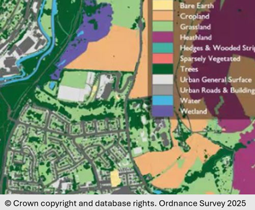
OS Enhanced Land Cover
Habitat and Land Cover data for Biodiversity Net Gain use cases in England.
Product DetailsOS Enhanced Land Cover is a combination of Ordnance Survey 25cm aerial imagery, 5m digital terrain model and data from the National Geographic Database (NGD Topography and NGD Land Cover) for England.
OS Enhanced Land Cover maps natural topographic area features for England to the European Nature Information System (EUNIS) and UK Biodiversity Action Plan (BAP) Broad Habitats classification schme values and provides a percentage of each land cover classification. Features are mapped to EUNIS habitat type hierarchical view (marine version 2022 & terrestrial version 2021) using Level 1 and Level 2 classification and UK BAP Broad Habitats classification 2008.
The Environment Act 2021 requires developers to provide a Biodiversity Net Gain of 10% 'more or better-quality natural habitat than there was before development'. OS Enhanced Land Cover enables ecologists, developers and landowners to address some of the challenges around baselining and monitoring land cover, habitats and biodiversity in line with Biodiversity Net Gain (BNG) legislation.
OS Enhanced Land Cover is intended for desktop analysis of natural habitats, to better plan field work (access and health & safety requirements) and to aid more efficient ‘ground truthing’ on site.
Technical Details
- Supplier
- Ordnance Survey
- Update Cycle
- N/A
- Coverage
- England
- Scale
- 1:1250-1:10 000
- Formats Available
- Stated Accuracy
- Stated Accuracy
- Stated Accuracy
- Licence Options
- Annual
- Delivery Timescale
- Within 24 hours
Related Products
Flooding products from JBA or Twinn (formerly Ambiental)
Download Samples
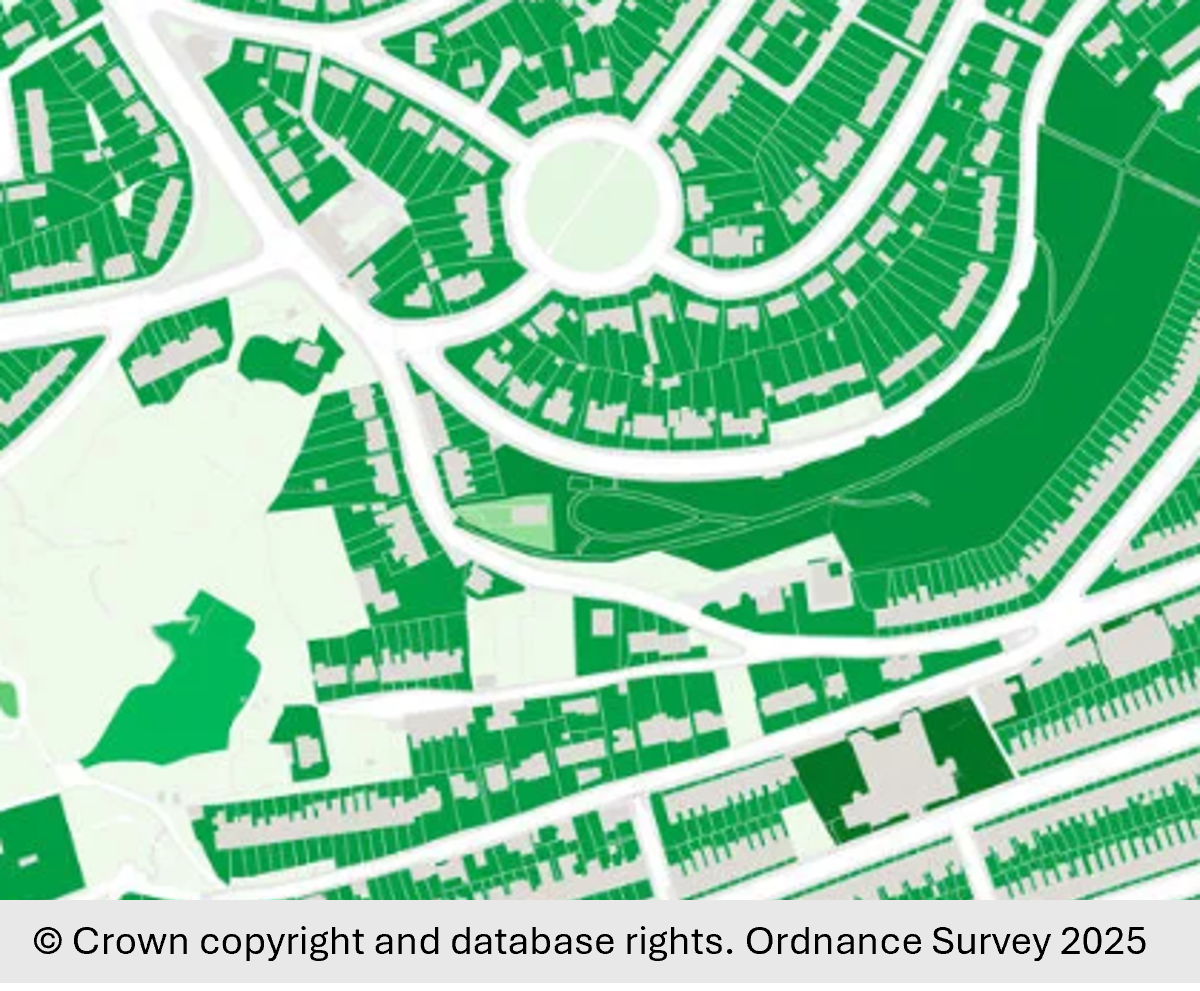
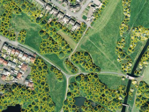
OS MasterMap GreenSpace Layer
Publicly accessible and private greenspaces in urban areas, helping to support initiatives around health and the environment.
Product DetailsOS MasterMap Greenspace Layer
OS MasterMap Greenspace Layer dataset depicts geographic areas classified as a type of greenspace in OS MasterMap Topography Layer. Includes publicly accessible and private spaces in urban areas larger than 6km2 (England & Wales) or 500+ population (Scotland), including sports facilities and natural environment features.
OS MasterMap Greenspace Layer provides with additional attribution for ‘function’ (e.g. allotment, cemetery, public park) and ‘form’ (e.g. Woodland, Open Semi-Natural, Manmade Surface). It is intended to support management of the local green environment, biodiversity, housing regeneration and flood resilience and encourage the promotion of increased physical activity and improved mental health/wellbeing.
Note: This product can be licensed until March-31st, 2026 (end-of-life)
OS Open Greenspace
OS Open Greenspace depicts the location and extent of publicly accessible, urban and rural greenspaces spaces along with access points where appropriate. Spaces include public parks, playing fields, sports facilities, play areas and allotments. Its primary purpose is to enable members of the public to find and access nearby greenspaces for exercise and recreation. OS Open Greenspace has generalised boundaries and less attribution than that provided with OS MasterMap Greenspace Layer.
Technical Details
- Supplier
- Emapsite
- Update Cycle
- Every 6-months
- Coverage
- GB
- Scale
- 1:1250 - 10:000
- Formats Available
- SHP, GDB, GML, DWG
- Stated Accuracy
- Stated Accuracy
- Stated Accuracy
- Sub-metre
- Licence Options
- Annual
- Delivery Timescale
- Within minutes
Related Products
Download Samples
UK-CEH Datasets
Datasets from UK Centre for Ecology & Hydrology (UK-CEH) describing the physical material on the surface of the United Kingdom.
Product DetailsUK-CEH Land Cover Map
Uses satellite imagery from 2023 to describe the physical material on the surface of UK in a set of land cover classes from grassland, woodland and fresh water to urban and suburban built-up areas. The UKCEH land cover classes are based on UK Biodiversity Action Plan (BAP) Broad Habitats and are updated annually. Available as vector polygons describing land cover for land cover parcels is above 0.5 hectare and as a raster dataset identifying the most likely UK Biodiversity Action Plan Broad Habitat for each pixel going back to 1999 (Note: pixel resolution increases with more recent years).
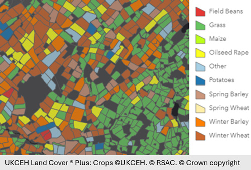
UKCEH Land Cover® Plus: Crops
Based on the UK-CEH Land Cover Map parcel framework categorises every land parcel categorised as agricultural land which is larger than 2 hectares is coded with crop type information (around 2 million land parcels). The product was originally developed in conjunction with the water industry to assist with catchment modelling of drinking water quality, reduce pollution and control the spread of crop diseases. From 2020, it also contains solar fields (sites with solar panels at ground level). Includes UK-CEH Land Cover Map.
UKCEH Land Cover® Plus: Fertilisers
Combines information on cropping patterns with national survey data on fertiliser use to map the estimated average total annual application of manufactured Nitrogen, Phosphorus and Potassium in England at 1km resolution. Has potential use for predicting environmental impacts (e.g. modelling agrochemical runoff, eutrophication and soil health) and Planning and environmental protection (e.g. catchment sensitive farming and estimates of gaseous emissions).
UKCEH Land Cover® Plus: Pesticides
Combines information on cropping patterns with national survey data on pesticide use to map the estimated average total annual application pesticides across England, Wales and Scotland at 1km resolution for 162 active ingredients. Has potential use for detecting the impact of pesticides on wildlife population trends, exposure risk of pollinating insects, modelling agrochemical runoff and water quality management in support of the Water Framework Directive.
Technical Details
- Supplier
- UK Centre for Ecology & Hydrology (UK-CEH)
- Update Cycle
- N/A
- Coverage
- As stated opposite
- Scale
- Formats Available
- On request
- Stated Accuracy
- Stated Accuracy
- Stated Accuracy
- Licence Options
- Annual
- Delivery Timescale
- Within 24 hours
Related Products
Flooding products from JBA or Twinn (formerly Ambiental)
Download Samples
Bluesky National Tree Map
Vector database of tree location, height and crown/canopy extents for trees above 3m in height across UK.
Product DetailsBluesky National Tree Map™ V2
Bluesky National Tree Map™ V2 is a vector database of trees created from high-resolution aerial photography, terrain and surface data, and colour infrared imagery data. It provides a comprehensive database of tree location, height and canopy/crown extents for trees above 3m in height across the whole of England, Wales and Scotland. The product is compatible with Ordnance Survey products and can be combined with other Bluesky products to make 3D visualisations.
Bluesky’s National Tree Map™ V2 provides a representation of how trees relate spatially to the built and natural environments around them and the hazards they pose. Onscreen visualisation provides insight relating to existence, size and position of trees for improved situational awareness and/or the need for additional field data collection. It is updated regularly as new aerial photography becomes available, ensuring that it remains the most detailed, comprehensive and up-to-date tree map.
Bluesky National Tree Map™ V2 represents a cost-effective solution for custodians responsible for the effective management of trees. It is useful for
- • Planning and development strategies to help prevent loss of or damage to ancient woodland and trees and their uniquely rich biodiversity and public sector bodies with environmental obligations;
- • Informing lenders and insurers of potential subsidence risks posed by trees to buildings and other assets (tree proximity, tree roots and drying out soils);
- • Identifying if trees might represent a hazard to health and safety or hamper operational activities (e.g. railways, traffic management, routing of high-sided vehicles, road and building maintenance, siting of mobile phone masts, site development);
- • Assisting facilities managers with a grounds maintenance responsibility.
Bluesky National Hedgerow Map
Created from Bluesky high-resolution, aerial photography, terrain and surface data, and colour infrared imagery, Bluesky National Hedgerow Map support initiatives to restore and create new hedgerows. It is a vector dataset indicating extent and volume of vegetation between 0.5m and 3m in height and is intended for hedgerow monitoring and management, carbon storage/above ground biomass calculations and for planning biodiversity wildlife corridors.
The dataset can be combined with Bluesky National Tree Map and is compatible with OS MasterMap products. This is currently a custom dataset created to order.
Technical Details
- Supplier
- Emapsite
- Update Cycle
- Quarterly
- Coverage
- GB
- Scale
- Formats Available
- CSV
- Stated Accuracy
- ± 1m RMSE
- Stated Accuracy
- Stated Accuracy
- Licence Options
- Annual
- Delivery Timescale
- Within 24 hours
Related Products
Digital Terrain Models from Ordnance Survey and Bluesky
Aerial imagery products from Ordnance Survey and Bluesky
Download Samples

MapImpact BiodiversityView™
Shows habitat type, condition and distinctiveness in GB to support Biodiversity Net Gain, ecological planning and strategic site assessment.
Product Details
MapImpact BiodiversityView provides a consistent, scalable view of habitat type, condition and distinctiveness to support Biodiversity Net Gain (BNG) assessments and ecological planning activities. It is aligned with the key inputs required for the DEFRA Biodiversity Metric Calculator and allows BNG unit scores to be generated for initial site screening and longer term monitoring.
- • Habitat Type aligns with the UK Habitat Classification Definitions (UKHAB)
- • Habitat Condition aligns with DEFRA Biodiversity Metric Calculator (1 to 3, Good, Moderate, Poor)
- • Habitat Distinctiveness defined by the DEFRA Biodiversity Metric
MapImpact BiodiversityView combines optical satellite data from Sentinel-2 imagery (collected during optimal vegetation season) with UKCEH Land Cover Map, Ordnance Survey OpenMapLocal and Priority Habitats, Ancient Woodland Inventories, and National Vegetation Coverage data from national agencies. The data is layered in a structured hierarchy and presented as a H3 hexagonal grid at Resolution 11 (0.22 hectares per cell) for a higher degree of connectivity reflecting the nature of habitats.
MapImpact BiodiversityView has been 'ground truthed' by certified ecologists and is useful for desk-based studies prior to site surveys by ecologists to satisfy BNG requirements.
Technical Details
- Supplier
- MapImpact
- Update Cycle
- TBA
- Coverage
- GB
- Scale
- 10:000
- Formats Available
- GPKG
- Stated Accuracy
- Stated Accuracy
- Stated Accuracy
- Licence Options
- Annual
- Delivery Timescale
- By arrangement
Related Products
Download Samples

Unrivalled resources
We simplify the supply and management of mapping products, plans and reports. Blending diverse datasets to uncover hidden commercial insights.

Business intelligence
Our spatial intelligence enables our clients to pinpoint areas of risk and reward, and to make better business decisions faster.

Proven partnership
We work in partnership, we're supportive, and we're committed to reducing our own and our clients' impact on the environment.