
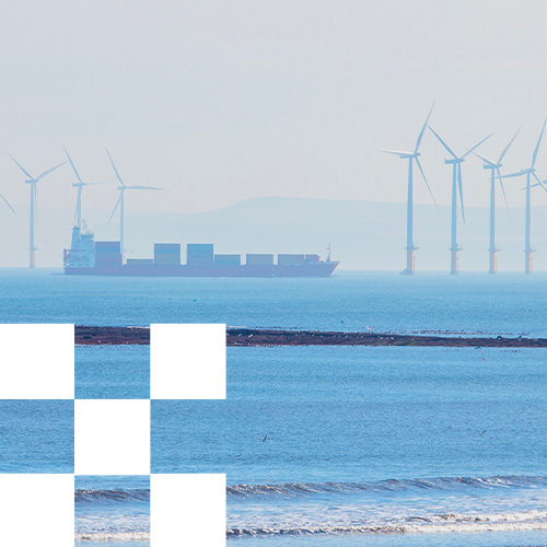
Marine Mapping and Data
Emapsite provides marine raster charts and marine vector datasets supplied by OceanWise, a recognised authority in marine geospatial data for coastal and offshore environments.
These datasets are produced in collaboration with national hydrographic offices and marine agencies, ensuring reliable, authoritative coverage for maritime planning, coastal management and marine infrastructure projects.
Data is available for UK and Irish waters and selected international regions, and is typically supplied as half-degree tiles to allow ordering for specific areas of interest or complete chart regions.
All datasets are georeferenced for use in GIS and spatial analysis platforms, enabling integration with terrestrial mapping, environmental data and infrastructure planning workflows.
What Marine Mapping Data is available?
Raster Charts
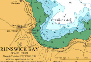
Raster Charts are digital versions of traditional nautical charts, derived under licence from the UK Hydrographic Office and other national hydrographic agencies.
They replicate the familiar layout, symbols and cartographic styling of paper charts while being fully georeferenced for GIS use.
Raster Charts are commonly used as a reference or background layer when working with marine infrastructure, coastal planning or environmental datasets.
Raster chart scales include:
- • Large scale – estuaries and harbours (greater than 1:30,000)
- • Medium scale – coastal waters (1:30,000 to 1:150,000)
- • Small scale – offshore sea areas (less than 1:150,000)
Raster Charts can be opened in standard image viewers and used within geographic information systems (GIS).
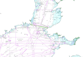
Raster Charts XL (Excluding Land)
Raster Charts XL are modified raster charts where the land areas are removed. This allows organisations to combine marine charts with terrestrial mapping datasets of their choice, such as Ordnance Survey mapping.
This format is particularly useful when integrating marine and land-based spatial data within GIS workflows.
International Marine Mapping
International Marine Mapping is also available for selected regions worldwide depending on international agreements. Please contact the Emapsite team to confirm data availability for your specific area of interest.
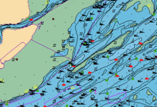
Marine Theme Vector
Marine Theme Vector datasets provide structured marine spatial data in vector format, organised into themed layers for analysis and querying. Unlike traditional charts, these datasets remove chart boundaries to create a continuous marine dataset suitable for spatial analysis. Each feature contains unique identifiers and attributes, enabling data linking and advanced GIS queries.
The dataset includes eight thematic layers covering:
- • Geographic regions
- • Administrative areas
- • Shipping and transport routes
- • Marine industrial facilities
- • Obstructions and shipwrecks
- • Elevation and bathymetry
- • Seabed geology
- • Tides and tidal currents
These datasets support marine spatial planning, environmental assessment and maritime infrastructure analysis.
Marine Themes Digital Elevation Model (DEM)
The Marine Themes Digital Elevation Model (DEM) provides a detailed seabed surface model derived from modern hydrographic survey data. The dataset incorporates the latest available single-beam and multi-beam sonar surveys and LiDAR data, which are assessed and combined through a deconfliction process to ensure data accuracy and consistency.
A coverage layer is also included, allowing users to identify the original survey source for each part of the dataset. Marine DEM data supports seabed analysis and bathymetry studies, offshore infrastructure planning, cable and pipeline routing and marine environmental assessments.

Marine Themes
Elevation models and region descriptions, ideal for general situation awareness, planning, site selection and investigation and outline engineering design.
Product DetailsMarine Themes are supplied as half-degree tiles for your area of interest.
OceanWise Marine Themes Bundle
Provides a collection of Oceanwise products at the largest scale available for a selected area of interest, comprising Marine Themes Elevation and Marine Theme Regions data along with scale-independent Marine Theme Feature layers for obstructions and shipwrecks, transport networks, industrial facilities and administrative areas. These layers are also available separately. Not to be used for navigation.
OceanWise Marine Themes Elevation
Provides subtidal, intertidal and land areas, contour areas and spot soundings to the largest scale available for a selected area-of-interest (Large, Medium or Small scale). Not to be used for navigation.
OceanWise Marine Themes Regions
Provides names of subtidal and intertidal areas, and other geographical or topographical features of public or historical interest to the largest scale available for a selected area-of-interest. Not to be used for navigation.
OceanWise Marine Themes Digital Elevation Model (DEM)
Marine Themes DEM is a seamless, seabed surface model, comprising detailed and accurate data of the seabed. The dataset utilises the most recent, commercially available single and multi-beam survey and LiDAR data, assessed and carefully selected in a deconfliction process. A coverage layer is also available to ensure the source of the data is always clearly defined. The product is supplied as half-degree tiles where available (1 arc second) along with two-degree tiles (6 arc seconds) included in the price. Not to be used for navigation.
Licence: PDF
Technical Details
- Supplier
- OceanWise Ltd
- Update Cycle
- Coverage
- UK & Irish waters
- Scale
- From greater than 1:30 000 (harbours, ports) to less than 1:150 000 (sea areas)
- Formats Available
- SHP
- Stated Accuracy
- Stated Accuracy
- Stated Accuracy
- Licence Options
- Annual
- Delivery Timescale
- within 4 working hours
Related Products
Land mapping for Great Britain, including OS MasterMap.
Download Samples
Sample data is provided for evaluations purposes only - coming soon.
Marine Themes Features
Scale independent, individual themed layers containing marine feature attributes for spatial analysis and data linking.
Product DetailsEngineered into logical data layers for easy loading and use in desktop and web-based Geographic Information Systems (GIS). Data attributes have been designed with analysis and querying in mind and chart boundaries have been removed to create a seamless, simplified dataset across charts. The data is derived from source data where available and supplied as half-degree tiles for a selected area of interest.
OceanWise MTF Obstructions & Wrecks
Indicates sunken ships and other disused man-made objects, including objects being re-used for another purpose and those of historical interest. Not to be used for navigation.
Buy OceanWise MTF Obstructions & Wrecks
OceanWise MTF PEXA (Military Practice & Exercise Areas)
Indicates designated areas which are used for training and defence purposes by the Royal Navy, the British Army, the Royal Air Force (RAF) and the Ministry of Defence (MoD). These include areas used for low level flying/bombing sorties, amphibious landing practice, live firing and demolition firing exercises. The product is available as a complete dataset for UK&Irish Waters. Not to be used for navigation.
OceanWise MTF Transport
indicates transport routes/networks and related infrastructure, including aids to navigation such as beacons, buoys and light marks (floats/vessels). Not to be used for navigation.
OceanWise MTF Industrial Facilities
indicates production, industrial, aquaculture and research facilities, including harbour facilities, hydrocarbon and renewable energy infrastructure, submarine cables and equipment for environmental monitoring. Not to be used for navigation.
Buy OceanWise Industrial Facilities
OceanWise MTF Administrative & Management Units
indicates areas of administration, governance, and management at international, national, regional, and local levels. Includes national boundaries, dumping sites, safety and prohibition zones and regulated fairways. Not to be used for navigation.
Buy OceanWise MTF Administrative & Management Units
OceanWise MTF Geology
indicates geological units including bedrock features and seabed sediments at 1:250 000 scale, along with attribute information for use in GIS (e.g. data age, material composition, categories and source date). Not to be used for navigation.
Oceanwise MTF Tides and Tidal Currents
Indicates tide-related features including stations and streams. Not to be used for navigation.
Buy OceanWise MTF Tides and Tidal Currents
Licence: PDF
Technical Details
- Supplier
- OceanWise Ltd
- Update Cycle
- Coverage
- UK & Irish waters
- Scale
- Scale independent
- Formats Available
- SHP
- Stated Accuracy
- Stated Accuracy
- Stated Accuracy
- Licence Options
- Annual
- Delivery Timescale
- within 4 working hours
Related Products
Land mapping for Great Britain, including OS MasterMap.
Download Samples
Sample data is provided for evaluation purposes only - coming soon.
Marine Raster Charts
Electronic versions of familiar nautical paper charts supplied as half-degree tiles at the largest scale available for whole chart area or for a selected area of interest.
Product DetailsOceanWise Marine Raster Charts
Electronic versions of familiar nautical paper charts and are derived under licence from the UK, and other, Hydrographic Offices. They can be opened using any image viewer software and are geo-referenced for use in geographical information systems (GIS). Raster Charts are ideal for applications where a set of familiar features and related symbology is required for reference or as a backdrop to other data.
Raster Charts are available in different scales in different sea areas. They are available at Large Scale for estuaries and harbours (greater than 1:30 000), Medium Scale for coastal waters (1:30 000 to 1:150 000) and Small Scale for sea areas (Less than 1:150 000).
Raster Charts are supplied as half-degree tiles in GeoTIFF format at the largest scales available for whole chart areas or for a selected area of interest (and may also include smaller scale data included in the price).
Not to be used for navigation.
Buy OceanWise Marine Raster Charts
Licence: PDF
Technical Details
- Supplier
- OceanWise Ltd
- Update Cycle
- Coverage
- UK & Irish waters
- Scale
- Various
- Formats Available
- TIFF
- Stated Accuracy
- Stated Accuracy
- Stated Accuracy
- Licence Options
- Annual
- Delivery Timescale
- within 4 working hours
Related Products
Land mapping for Great Britain, including OS MasterMap.
Download Samples
Sample data is provided for evaluations purposes only - TIF
Marine Raster Charts XL
Familiar nautical raster chart which eXcludes Land (XL) for combining with land mapping of your choice.
Product DetailsOceanWise Marine Raster Charts XL
Electronic versions of familiar nautical paper charts but with land mapping excluded so that alternative land mapping may be combined for a preferred view.
Marine Raster Charts XL can be opened using any image viewer software and are geo-referenced for use in geographical information systems (GIS). These charts are ideal for applications where a set of familiar features and related symbology is required for reference or as a backdrop to other data.
Marine Raster Charts XL are available in different scales in different sea areas. They are available at Large Scale for estuaries and harbours (greater than 1:30 000), Medium Scale for coastal waters (1:30 000 to 1:150 000) and Small Scale for sea areas (Less than 1:150 000).
Supplied as half-degree tiles in GeoTIFF format at the largest scales available for whole chart areas or for a selected area of interest. May also include smaller scale data (included in the price).
Not to be used for navigation.
Licence: PDF
Technical Details
- Supplier
- OceanWise Ltd
- Update Cycle
- Coverage
- UK & Irish waters
- Scale
- From greater than 1:30 000 (harbours, ports) to less than 1:150 000 (sea areas)
- Formats Available
- TIFF
- Stated Accuracy
- Stated Accuracy
- Stated Accuracy
- Licence Options
- Annual
- Delivery Timescale
- within 4 working hours
Related Products
Land mapping for Great Britain, including OS MasterMap.
Download Samples
Sample data is provided for evaluations purposes only. This sample data is provided in two parts which combine to make a complete sample.
Marine Geology
Indicates geological features of the seabed for UK Continental Shelf areas.
Product DetailsOceanWise MTF Geology
Marine Themes Features Geology indicates geological units including bedrock features and seabed sediments for UK waters for use in GIS. The product contains Line and Polygon layers recorded at 1:250 000 scale, along with attribute information (e.g. data age, material composition, categories and source date).
Not to be used for navigation.
Technical Details
- Supplier
- OceanWise Ltd and British Geological Survey
- Update Cycle
- Coverage
- UK Continental Shelf areas
- Scale
- 1:250 000
- Formats Available
- SHP
- Stated Accuracy
- Stated Accuracy
- Stated Accuracy
- Licence Options
- Annual
- Delivery Timescale
- Within 4 working hours
Related Products
Land mapping for Great Britain, including OS MasterMap.
Download Samples
Sample data is provided for evaluations purposes only.
Oceanwise MTF Geology - coming soon
BGS Seabed Sediments 250k - SHP
BGS Offsore bedrock 250k - coming soon.

Unrivalled resources
We simplify the supply and management of mapping products, plans and reports. Blending diverse datasets to uncover hidden commercial insights.

Business intelligence
Our spatial intelligence enables our clients to pinpoint areas of risk and reward, and to make better business decisions faster.

Proven partnership
We work in partnership, we're supportive, and we're committed to reducing our own and our clients' impact on the environment.