
Location data for Housing Associations
Emapsite provides the expertise and data to help Housing Associations, large and small, gain insight, save money, improve efficiency and deliver on their environmental goals.
Emapsite's mapping and location data for Housing Associations helps you reduce costs and deliver on your goals. By improving your understanding of risk and asset management, right down to individual address-level, you will have the power to accurately locate, report, plan and respond.

Housing Associations - meet your goals
We understand your challenges
Having helped Housing Associations all over the country for many years, the chances are, we’ve already developed a solution for many of your common data challenges. We know you have plans to reduce carbon emissions and want access to environmental data. Some planners and asset managers are looking towards Smart technology, which means using location insights in a whole new way.

Why choose Emapsite?
By choosing us you can leverage our commercial experience and knowledge across housing, renewables, waste management, insurance, forestry management and more.
Being able to both visualise and analyse your data, together with the specialist data available from us, will enable you to:
• Manage your stock more effectively
• Understand property allocation
• Manage property lifecycles and planning processes
• Reduce ground maintenance costs
• Create detailed, shareable desktop reports
• Verify rights of way and property boundaries
• Make confident decisions through clarity of data
• Verify and manage ownership

Housing Associations - do you know what you need?
Emapsite’s team offers advice, support and easy-to-access location data. All the plans and mapping you need, in the format that makes it easy to use and with the correct licensing.
Once we have used our cutting-edge geocoding on your own data for accurate address matching, that data can be used for everything from basic land and asset management to, utilities' management, and bespoke insights that help you plan, and reduce costs and risks.
If you are using GIS already you will probably know what you need. Emapsite offers the largest range of standard location data such as:
• OS MasterMap for detailed background images
• EPC reports for improvement targeting
• Utility reports for development
• Address data for accurate reporting
• Planning tools including aerial photography
• HM Land Registry insights to understand ownership
• Tree data to manage risk and plan new planting
Our mapping data outputs are multi format, regardless of the software or supplier you use Emapsite can supply.
Thanks to our experience, we can also advise you on how others are benefiting from our data, and help you find cost-cutting value in the data you’re creating in-house, consequently achieving greater benefit from the location data you're using.
We understand that most housing associations' stock changes, with additions and disposals and stock transfers during the data licensing period, adding to your data holding during this is also made easy with Emapsite.
How can we help?
Wherever you are in your GIS journey, Emapsite can help you realise the value of location data.
The widest range of professionals working with Housing Associations already trust us for all their location data needs - everything from OS mapping, utilities' data environmental reports and more.
However, our team doesn’t just give you access to off-the-peg products. For Housing Associations who are more advanced in their use of GIS, we also partner on location data innovation projects, unlocking the value from the raw data you’re collecting or using, to deliver a key advantage.
• Online mapping to deliver granular insights, instantly.
• Access to innovation managers, machine learning and exclusive data services
• The ideal datasets for site analysis, and land, stock and risk management.
• Download formats that support CAD and GIS, and online dashboards.
Emapsite can work with you to improve your data use and ultimately deliver on your short, medium and long term goals, speak with one of our specialist housing team today to find out more.

AddressBase
Address data produced and maintained by Geoplace (the centre of excellence for spatial address and street information in Great Britain, with input from all local government authorities in GB and distributed by Ordnance Survey Partners.
Find out more
OS MasterMap Topography Layer
OS MasterMap is the most detailed, current and comprehensive map dataset of Great Britain, enabling you to make better decisions and manage your assets more effectively. Working with the other mapping layers in the suite, OS MasterMap Topography Layer gives you the visual context to help interpret addresses, routes and imagery. OS MasterMap is the approved dataset for planning applications and land registration.
Find out more

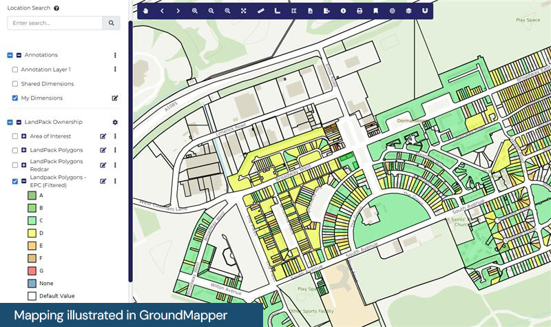
Emapsite LandPack Title and Tenure
Emapsite LandPack Title and Tenure provides Emapsite LandPack Polygons plus OS MasterMap Topography Layer for a customer's area of interest. The product indicates freehold and leasehold polygons and areas where no data is held, along with property information such as property type, built form and construction age plus current energy consumption, rating, efficiency and carbon dioxide (CO2) emissions.
Find out more

Twinn FloodScore Climate
FloodScore Climate provides a view of climate-related, property-level flood risk information for Great Britain. The product provides an estimate of the likelihood and severity of climate-related flood hazards affecting each individual property and is intended for use by property investors, mortgage lenders, property owners (e.g. Housing Associations) and insurers.
Find out more

OS MasterMap Imagery Layer
The aerial images give added context to features which exist within other (vector) OS MasterMap layers and allow interpretation of other features not identified within the vector datasets. The data is rigorously checked for quality to maintain a consistent standard of both positional accuracy and image quality.
Find out more

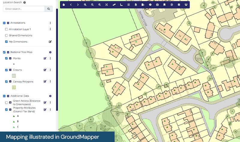
National Tree Map
National Tree Map includes a Tree Crown layer showing crown coverage and maximum, minimum and mean height. The attribution allows a variety of visualisations to be carried out, including classifying tree cover by height or canopy size, filtering out of trees under a certain height, etc.
Find out more