
Flooding Hazard
Flooding is a major hazard in Great Britain. An estimated five million households - one in five - are at risk to flooding. And annual damage from flood is estimated at between £500 million and £1 billion each year.
Data from Met Office UK Climate Projections (UKCP) indicate that the UK is likely to receive more bouts of heavy rain more frequently as temperatures rise as a result of climate change. The number of flood events is likely to increase, and along with it, the potential for loss and damage. Data for different types of flooding (groundwater, surface, river and coastal flooding) is key to managing the risk both now and in the future.
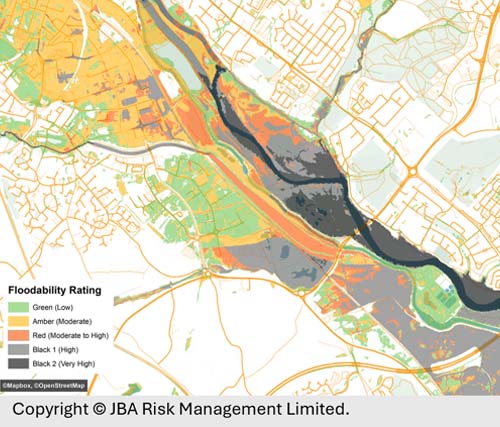
We supply UK flood hazard and risk mapping in many formats from leading specialists JBA Risk Management and Royal Haskoning (Twinn, Ambiental). We supply data and web services to planners, developers, lenders and insurers alike for assessing the likelihood of flooding and mitigating risk.
Since April, 2022, it has been mandatory for the largest UK-registered companies and financial institutions to disclose climate related financial information inline with TCFD recommendations (Task Force on Climate-Related Financial Disclosures).
Our Flood hazard and risk mapping and data identify current and future risk from climate-related factors, such as flood, vital to that activity.
Our climate intelligence and web services can drive your automated outputs, feed into consumer-facing reports, and give you the foundations on which to build strong and measurable insights about climate-related, physical and transitional risk management.

Unrivalled resources
We simplify the supply and management of mapping products, plans and reports. Blending diverse datasets to uncover hidden commercial insights.

Business intelligence
Our spatial intelligence enables our clients to pinpoint areas of risk and reward, and to make better business decisions faster.

Proven partnership
We work in partnership, we're supportive, and we're committed to reducing our own and our clients' impact on the environment.