
Aerial Imagery
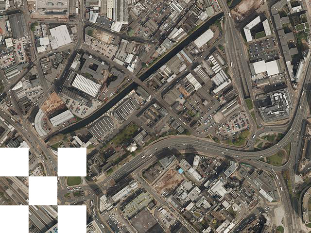
Aerial imagery (aerial photography) provides a high-resolution bird’s-eye view of the landscape, capturing detail about the Earth’s surface such as buildings, vegetation, infrastructure and land use.
This imagery reveals features that are difficult to identify from ground-level observation or standard mapping alone, such as roof structures, solar panels, transport infrastructure and land-use change.
Organisations use aerial imagery to support planning, environmental assessment, infrastructure development, asset management and land analysis.
Why use aerial imagery?
Aerial imagery provides a reliable visual record of the landscape that can support analysis, modelling and monitoring. Typical applications include:
- • Planning and development - site assessment, land use analysis and visual context
- • Environmental monitoring - biodiversity mapping and habitat change detection
- • Infrastructure planning - transport networks, utilities and energy projects
- • Asset management - identifying equipment, signage and infrastructure features
- • Change detection - monitoring landscape or urban development over time
Available aerial imagery resolutions
Emapsite licenses aerial imagery from leading data providers across Great Britain, offering multiple resolution options depending on the level of detail required.
Resolutions:
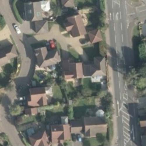
12.5cm:
Typical Visibile Detail - Roof tiles, street furniture
Common Use Cases - Urban planning, EV charging site planning, solar panel installation analysis, detailed asset management
25cm:
Typical Visibile Detail - Vehicles, building features
Common Use Cases - Environmental impact assessments, property analysis, infrastructure planning
50cm:
Typical Visibile Detail - Building types, road networks
Common Use Cases - Habitat mapping, regional infrastructure planning
1m:
Typical Visibile Detail - Building footprints, agricultural fields
Common Use Cases - Forestry analysis, agricultural planning, urban growth monitoring
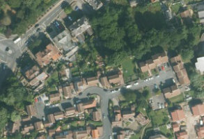
2m:
Typical Visibile Detail - General land cover
Common Use Cases - Regional land use analysis, national-scale planning
OSMM Imagery Layer
Reliable, consistent orthorectified aerial imagery/photography for GB at 25cm resolution for general business use.
Product DetailsOS MasterMap Imagery Layer provides a reliable and consistent source of orthorectified, aerial photography at 25cm resolution for general business use. The product is colour-balanced, and edge matched to minimise misalignment or inconsistency at image boundaries.
OS MasterMap Imagery Layer is used in a variety of use cases. Features align consistently with OS MasterMap Topography Layer data to add visual and contextual capability, considerably enhancing mapping projects for surveyors, engineers, planners and many more
- • Site evaluation
- • Land-use cover/land use analysis
- • Property management and planning applications
- • Asset management
- • Property insurance
- • Risk analysis
- • Route planning and site accessibility
- • Environmental monitoring
Ordnance Survey has invested considerable resources to provide orthorectified imagery that achieves the consistently high standard for shape, position and colour. Priority is given to positional accuracy and ensuring details can be seen within shadows, with consistent mosaicing and edgematching between areas of imagery collected at different times. The data is typically between 3 and 5 years old.
Buy OS MasterMap Imagery Layer
License: PDF
Technical Details
- Supplier
- Emapsite
- Update Cycle
- Quarterly
- Coverage
- Great Britain
- Scale
- 1:1250 to 1:10 000
- Formats Available
- TIF, JPG, BMP, PNG
- Stated Accuracy
- 1.1 m root‑mean‑square error (RMSE)
- Stated Accuracy
- Stated Accuracy
- Licence Options
- Annual
- Delivery Timescale
- Within 24 hours
Related Products
Download Samples
Bluesky Aerial Photography
Vertical imagery data across GB at various resolutions from 2-metre (low resolution) to 12.5-cm (high resolution) for a variety of business applications.
Product DetailsBluesky is a specialist in the acquisition and processing of aerial photography and in the creation of high quality digital imagery and terrain products. By investing in the latest airborne camera technology, Bluesky ensures the quality, accuracy and consistency of its imagery to the highest standard. Bluesky is the sole supplier of aerial photography and digital terrain models to public sector organisations in Great Britain, having been awarded the Aerial Photography for Great Britain contract (APGB) by the Geospatial Commission in 2024.
Bluesky data is updated on a rolling, two-year cycle. This increased capture frequency assists with growing concerns about tackling issues like climate change and achieving targets for carbon emission reduction.
The following products may be ordered in our mapshop and 5cm resolution imagery is available on request for some urban centres:
Bluesky Aerial Photography 12.5cm
- • Detailed urban and electric vehicle charging site planning
- • Solar panel installation studies
- • Asset management (identifying equipment, signs etc.)
Bluesky Aerial Photography 25cm
- • Environmental impact assessments for development projects
- • General property assessment
- • Infrastructure planning and retail site analysis
Bluesky Aerial Photography 50cm
- • Wildlife habitat mapping
- • Regional development/infrastructure planning
Bluesky Aerial Photography 1m
- • Forestry management/agricultural planning
- • Urban sprawl analysis
Bluesky Aerial Photography 2m
- • Regional economic development planning
- • National scale land use planning
Technical Details
- Supplier
- Emapsite
- Update Cycle
- Every two-years
- Coverage
- GB
- Scale
- From 2m resolution to 12.5cm (with 5cm in some urban areas)
- Formats Available
- TIF, JPG, PNG, BMP
- Stated Accuracy
- 12.5cm Accuracy +/– 0.3m RMSE
- Stated Accuracy
- 25cm Accuracy +/– 0.6m RMSE
- Stated Accuracy
- Licence Options
- Annual
- Delivery Timescale
- Within minutes
Related Products
Download Samples
Getmapping Aerial Photography
Vertical imagery data across GB at various resolutions from 2-metre (low resolution) to 12.5-cm (high resolution) for a variety of business applications.
Product DetailsGetmapping pioneered the concept of nationwide coverage of aerial photography and is a leading provider of geospatial data. Getmapping has over 25 years expertise with over 25 years expertise in capturing and delivering high-resolution aerial imagery, from 2-metre (low resolution) to 12.5-centimetre resolution (high resolution) for a variety of business applications.
Getmapping aerial imagery data is updated on a rolling, three-year cycle and the following products can be ordered in our mapshop:
Getmapping Aerial Photography 12.5cm
- • Detailed urban and electric vehicle charging site planning
- • Solar panel installation studies
- • Asset management (identifying equipment, signs etc.)
Getmapping Aerial Photography 25cm
- • Environmental impact assessments for development projects
- • General property assessment
- • Infrastructure planning and retail site analysis
Getmapping Aerial Photography 50cm
- • Wildlife habitat mapping
- • Regional development/infrastructure planning
Getmapping Aerial Photography 1m
- • Forestry management/agricultural planning
- • Urban sprawl analysis
Getmapping Aerial Photography 2m
- • Regional economic development planning
- • National scale land use planning
Technical Details
- Supplier
- Ordnance Survey
- Update Cycle
- Quarterly
- Coverage
- Great Britain (and elsewhere)
- Scale
- From 2m to 12.5cm resolution (with 5cm in some urban centres)
- Formats Available
- JPG, TIF, PNG, BMP
- Stated Accuracy
- +/- 0.75m RMSE
- Stated Accuracy
- Stated Accuracy
- Licence Options
- Annual
- Delivery Timescale
- Within minutes
Related Products
Download Samples

Unrivalled resources
We simplify the supply and management of mapping products, plans and reports. Blending diverse datasets to uncover hidden commercial insights.

Business intelligence
Our spatial intelligence enables our clients to pinpoint areas of risk and reward, and to make better business decisions faster.

Proven partnership
We work in partnership, we're supportive, and we're committed to reducing our own and our clients' impact on the environment.