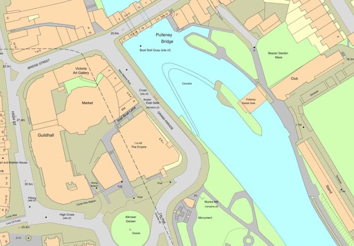
OS MasterMap®

OS MasterMap® is the most detailed and accurate view of Great Britain's landscape. Buy OS Mastermap® from a trusted supplier with over 25 years experience from only £17.99. With dedicated support included at the end of a phone to answer all your queries it offers great value for money.

Download OS Mastermap in minutes in a variety of formats from the Emapshop MapShop App. The world's most friendly location data MapShop. Simply choose the area you're looking for, then buy and download what you need immediately. 

Choose OS MasterMap® or select one of our other large scale mapping items. For queries about our products contact us.

Shop the Emapsite MapShop

OS MasterMap®  with Dedicated Support | Emapsite

Some of our popular OS MasterMap® products

Below you'll find a selection of some of the best-selling products available through the Emapsite online MapShop.


Choose OS MasterMap® or select one of our other large scale mapping items, or browse our pre-blended options – OS MasterMap® combined with third party data, speeding up your work and making life easier.

OS MasterMap Detailed Mapping

OS MasterMap Topography Layer (Building Heights included)

OS MasterMap Topography Layer® is the most detailed and accurate view of Great Britain's landscape – from roads to fields, to buildings and trees, fences, paths and more.

Tell me more about OS MasterMap Topography Layer >

OS MasterMap Topography Layer® is the most detailed, current and comprehensive map dataset of Great Britain, enabling you to make better decisions and manage your assets more effectively. Working with the other mapping layers in the suite, OS MasterMap Topography Layer® gives you the visual context to help interpret addresses, routes and imagery and is the approved dataset for planning applications and land registration.

Continually updated, OS MasterMap contains Topography Layer® 450 million geographic features found in the real world, from detailed building and road outlines to water features, pathways, bus shelters and letter boxes.

Licence: PDF

OS MasterMap Topography Layer® is ideal for:

  • Use in CAD or GIS
  • Planning
  • Site location and evaluation
  • Risk management
  • Transport and infrastructure
  • Asset management
  • Environmental analysis

Technical Details

Supplier
Ordnance Survey
Update Cycle
6 weekly
Coverage
GB
Scale
1:1250
Formats Available
DWG, SHP, GML, TAB, DXF, GDB, KML, TIFF
Stated Accuracy
Urban +/- 1m
Stated Accuracy
Rural +/- 8m
Stated Accuracy
+/- 8m
Licence Options
12, 24 or 36 months
Delivery Timescale
Within minutes

Related Products

PDF Plans, Aerial PhotographyOS MasterMap Highways Layer, OS Mastermap ITN, OS Mastermap Imagery Layer, Lidar, AddressBase Plus

Download Samples

OS MasterMap 3D - Building Heights and OS Terrain 5

OS MasterMap is the most detailed & accurate view of Great Britain's landscape – with roads, fields, buildings, trees, fences & more. Combined with OS Terrain 5 as a single file, saving time & money.

Tell me more about OS MasterMap 3D - Building heights & OS Terrain 5 >

OS MasterMap is the most detailed, current and comprehensive map dataset of Great Britain, enabling you to make better decisions and manage your assets more effectively. Working with the other mapping layers in the suite, OS MasterMap Topography Layer gives you the visual context to help interpret addresses, routes and imagery. OS MasterMap is the approved dataset for planning applications and land registration.

Continually updated, OS MasterMap contains 450 million geographic features found in the real world, from detailed building and road outlines to water features, pathways, bus shelters and letter boxes.

OS MasterMap is ideal for:

  • Use in CAD or GIS
  • Planning
  • Site location and evaluation
  • Risk management
  • Transport and infrastructure
  • Asset management
  • Environmental analysis

OS Terrain 5 is ideal for:

OS Terrain 5 is particularly valuable for large scale development projects, planning, impact assessment

OS Terrain 5 offers detailed modelling of significant features such as road, rail, quarries and lakes​ allowing you to asses the lie of the land on-screen and reduce the need for site visits. OS Terrain 5 has a root mean square error (RMSE) value of 1.5 metres in urban areas and major communication routes. 

OS Terrain 5 is maintained as part of the same revision process as the Ordnance Survey's large scale datasets and so adds a valuable third dimension to OS MasterMap Topography Layer.

Licence: PDF

Technical Details

Supplier
Ordnance Survey
Update Cycle
6 weekly
Coverage
GB
Scale
1:1250 (OS MasterMap) and 5m (Terrain 5)
Formats Available
DWG, SHP, PDF
Stated Accuracy
Urban +/- 1m (OS MasterMap)
Stated Accuracy
Rural +/- 8m (OS MasterMap)
Stated Accuracy
+/- 8m (OS MasterMap)
Licence Options
12, 24 or 36 months
Delivery Timescale
Within minutes

Related Products

PDF Plans, Aerial PhotographyOS MasterMap Highways LayerOS Mastermap Imagery Layer, Lidar, AddressBase Plus

Download Samples

OS MasterMap NON-GEO

Detailed large scale non-georeferenced raster mapping of Great Britain (1:1 250).

Tell me more about OS MasterMap NON-GEO >


BUY NOW

OS MasterMap NON-GEO
Detailed large scale non-georeferenced raster mapping of Great Britain (1:1 250).

OS MasterMap® raster is suitable for display and printing at 1:500 to 1:10 000 scales.

OS MasterMap® Available for areas up to and including 1 sq km (100 ha).

Technical Details

Supplier
Ordnance Survey
Coverage
GB
Scale
1:1250

Related Products

OS MasterMap Topography LayerOS MasterMap ITN, OS MasterMap Imagery Layer, Lidar

Download Samples

OS MasterMap Roads and Routing map image

OS MasterMap Highways Network - Roads / Roads & Routing / Paths

OS MasterMap Highways Network® provides an authoritative view of the whole road network in Great Britain, ideal for routing and public sector data-sharing. Roads, Roads & Routing, Paths.

Tell me more about OS MasterMap Highways Network >

OS Mastermap Highways Network® is the Ordnance Survey's latest and most comprehensive dataset of Great Britain's road network and is the next generation of the well-known product OS ITN. It is comprised of a suite of products that brings together the best information from authoritative sources in to one central location.

OS MasterMap Highways Network - Roads: Ordnance Survey road network of Great Britain

OS Mastermap® Highly detailed road geometry supplied with essential unique identifiers, including the Unique Street Reference Numbers (USRNs) and topographic identifiers (TOIDs) enables linking and sharing of data against the road and street networks.

OS Mastermap Highways Network - Roads & Routing: Ordnance Survey Roads Routing and Asset Management Information for Great Britain's road network.

OS MasterMap® Provides OS road network geometry and associated routing restriction information for detailed route planning and network analysis. RAMI is an extended part of the Highways Network suite of data including turn, height, weight and width restrictions, bollards and traffic calming.

OS MasterMap Highways Network - Paths: Ordnance Survey footpath dataset of Great Britain's footpaths connecting to Roads

OS MasterMap® A path network dataset for Great Britain showing who is responsible for all the footpaths through towns and cities. The dataset helps understand how people connect to towns and cities around them. Unique Street Reference Number (USRN) links this data AddressBase datasets for Search or Navigation.

In addition to road centre lines and classifications, Highways features richer content that is better structured to allow for analysis as well as visualisation. Highways has been designed with traffic analysis, asset management, planning and the emergency services in mind, allowing users to plan for tomorrow. It gives you accurate and precise asset management information on who maintains the road network and the type of surface reinstatement values. And it's a valuable reporting tool, for key facts and statistics about the road, against a consistent and authoritative base.

OS Highways - Roads can be extended using OS Highways - Routing, and OS Highways - Paths

Licence: PDF

OS Highways - Roads attribution includes:

  • road classification, naming and numbering
  • vehicle restrictions
  • links to OS Addressbase and the USRN
  • roads under construction
  • public/private maintained roads
  • special engineering difficulty
  • special event information
  • road hazards: overhead structures, level crossings, movable bollards, gates
  • protected streets
  • traffic sensitive roads

OS Highways - Routing additionally includes:

  • turn restrictions

OS Highways - Paths additionally includes:

  • links between roads/paths
  • dedication types


Technical Details

Supplier
Ordnance Survey
Coverage
GB
Scale
1:1250

Related Products

OS MasterMap Topography LayerOS MasterMap ITN, OS MasterMap Imagery Layer, Lidar

Download Samples

OS MasterMap Highways Network - Roads: SHP, GML, DWG

OS MasterMap Highways Network - Routing and Asset Management: SHP

OS MasterMap Highways Network - Paths: SHP, GML


Buy OS MasterMap Highways Network >

OS MasterMap Detailed Mapping

OS MasterMap Graphic

OS MasterMap Graphic is a picture version of OS Mastermap, the most detailed and accurate view of Great Britain's landscape

Tell me more about OS MasterMap Graphic >

OS MasterMap Graphic is a simple image-only version of OS Mastermap Topography Layer, the most detailed, current and comprehensive map dataset of Great Britain. When you only need an image of Mastermap and have no requirement to use it in CAD or GIS software, OS Mastermap Graphic is your best choice - a cost effective way of getting the image you need to use within document creation. Please note that OS Mastermap Graphic is a raster image only, with no georeferencing information, so isn't suitable if you need to measure distances.

Licence: PDF

OS MasterMap Graphic is ideal for:

  • When you need an image of large scale mapping
  • Using within word processing and graphic design programs
  • Detailed site maps for brochures and guides
  • Site location and evaluation
  • Risk management
  • Transport and infrastructure
  • Asset management

Technical Details

Supplier
Ordnance Survey
Update Cycle
6 weekly
Coverage
GB
Scale
1:1250
Formats Available
TIFF, BMP, PNG, JPG
Stated Accuracy
Urban +/- 1m
Stated Accuracy
Rural +/- 8m
Stated Accuracy
+/- 8m
Licence Options
12, 24 or 36 months
Delivery Timescale
Within minutes

Related Products

PDF Plans, OS MasterMap Topography LayerOS Mastermap Imagery LayerAerial Photography

Download Samples

OS MasterMap Water Network data image

OS MasterMap Networks - Water Layer

The OS MasterMap Networks - Water Layer® is a detailed, accurate and up-to-date vector dataset of Great Britain’s water network - rivers, streams, lakes and canals.

Tell me more about OS MasterMap Networks >

The OS MasterMap Networks - Water Layer®​ is the only detailed, heighted water network of Great Britain showing the flow and precise course of rivers, streams, lakes and canals.​ 

It offers the most accurate view of all watercourses across the whole of Great Britain created, in collaboration with the Environment Agency and Scottish Environmental Protection Agency, to a consistent specification and update schedule – so it can help support flood risk management decisions and the sharing of information between national and local organisations.

Accurate physical properties of watercourses enable modelling in 2D and 3D like never before, thanks to the clear and detailed information about river flow, gradient and river widths, along with its precisely mapped course.

The data maps a wide range of features, from aqueducts to tunnels with full flow direction and for the first time the network of underground watercourses – inferred from the entry and exit points.

Licence: PDF

OS MasterMap Networks - Water layer® is ideal for:

Planners, for surveyors, for engineers – this Layer offers the potential to model in 2D and 3D like never before, thanks to the clarity of river flow, gradient and river widths.

Technical Details

Supplier
Ordnance Survey
Coverage
GB
Scale
1:1250
Formats Available
DWG, SHP, GML, TAB, DXF, GDB, KML, TIFF
Stated Accuracy
Urban +/- 1m
Stated Accuracy
Rural +/- 8m
Stated Accuracy
+/- 8m
Licence Options
12, 24 or 36 months
Delivery Timescale
Within minutes

Related Products

OS MasterMap Topography Layer, Aerial PhotographyOS MasterMap Imagery Layer, Lidar

Download Samples

Aerial imagery sample

OS MasterMap Imagery Layer

The OS MasterMap Imagery Layer® comprises the best available aerial images, edge-matched and orthorectified to align with other OS MasterMap layers.

Tell me more about OS MasterMap Imagery Layer >

The aerial images give added context to features which exist within other (vector) OS MasterMap layers and allow interpretation of other features not identified within the vector datasets. The data is rigorously checked for quality to maintain a consistent standard of both positional accuracy and image quality.

Additionally Ordnance Survey processing software produces true-orthorectified imagery, removing building lean from aerial imagery to give you a consistent top-down view.

Aerial imagery is ideal for checking road markings, tree canopies or site entrances, cutting down the need for site visits, so you can save money and manage time more efficiently.

Purchasable as both a traditional raster cut-out of a user defined area or as web services.

Licence: PDF

OS MasterMap Imagery layer® is ideal for:

  • Planning
  • Site location and evaluation
  • Land use classification and analysis
  • Transport and infrastructure
  • Asset management
  • Environmental analysis
  • Flood mapping
  • 3D visualisation

.

Technical Details

Supplier
Ordnance Survey
Update Cycle
Quarterly
Coverage
GB
Scale
25cm resolution
Formats Available
TIFF, JPG, BMP
Licence Options
Annual, Perpetual
Delivery Timescale
Within minutes

Related Products

OS MasterMap Topography LayerAerial PhotographyLidar, AddressBase Plus

Download Samples

OS MasterMap PDF Location Plan

A plan at 1:1250 scale in PDF format tailored for submitting to your local authority for a range of planning applications

Tell me more about OS MasterMap PDF Location Plan >

All Location Plans come complete with a north arrow and scale bar automatically. Your plan is free to edit after purchase. 

Location Plans are processed automatically and a PDF plan is emailed within minutes.

Unusually large plans are made available to download, which also typically takes just a few minutes.

Location Plan PDFs are ready to send to your local authority electronically and ready to print.

Licence: PDF

Technical Details

Supplier
Ordnance Survey
Update Cycle
6 weekly
Coverage
GB
Scale
1:1250
Formats Available
PDF, PNG
Licence Options
Perpetual
Delivery Timescale
Within minutes

Related Products

OS MasterMap Topography LayerAerial Photography

Download Samples

OS MasterMap 1:1,250 Scale 4ha in Colour (A4)PDF

OS MasterMap 1:1,250 Scale Large Template in Colour (A4)PDF

OS MasterMap 1:1,250 Scale 2ha in Black & White (A4)PDF


Buy OS MasterMap PDF Location Plan


OS MasterMap PDF Site/Block Plan

A colour plan at 1:500 scale in PDF format tailored for submitting to your local authority for a range of planning applications.

Tell me more about OS MasterMap PDF Site/Block Plan >

All Site/Block Plans come complete with a north arrow and scale bar. Your plan is free to edit after purchase.

Site/Block Plans process automatically and are ready within minutes.

Unusually large plans are made available to download, which also typically takes just a few minutes.

Site/Block Plans are ready to send to your local authority electronically and ready to print.

Licence: PDF

Technical Details

Supplier
Ordnance Survey
Update Cycle
6 weekly
Coverage
GB
Scale
1:500
Formats Available
PDF, PNG
Licence Options
Perpetual
Delivery Timescale
Within minutes

Related Products

OS MasterMap Topography LayerAerial Photography

Download Samples

OS MasterMap 1:500 Scale Block/Site Plan in Colour (A4): PDF

(Black & White also available)

Buy OS MasterMap PDF Site/Block Plan >

emapsite Land Title and Tenure mapping data

Emapsite LandPack Title and Tenure

​OS MasterMap enriched with HM Land Registry Polygons, along with additional property information such as property type, construction age and EPC data.

Tell me more about Emapsite LandPack Title & Tenure >

​Emapsite LandPack Title and Tenure provides Emapsite LandPack Polygons plus OS MasterMap Topography Layer for a customer's area of interest.  The product indicates freehold and leasehold polygons and areas where no data is held (perhaps because ownership information is held in paper deeds, by a mortgage provider/solicitor or there is no owner) along with property information such as property type, built form and construction age plus current energy consumption, rating, efficiency and carbon dioxide (CO2) emissions.

There may be more than one polygon per Title (e.g.  where a house with a garden has a garage located separately).  

You can purchase emapsite Land Title and Tenure through our online mapshop, where you can define your area of interest and purchase in a range of GIS formats.

Licence: PDF

Common uses:

Ideal for project and site specific users in a variety of sectors where land parcel information is required, including planning, site development and asset management.

Technical Details

Update Cycle
6-weekly
Coverage
England and Wales
Scale
1:1250
Formats Available
SHP, GDB, DWG
Licence Options
Annual

Related Products

OS MasterMap Topography LayerAddressBase Plus

Download Samples

emapsite Commercial Land Ownership mapping data

HMLR NSD Polygons and Commercial Ownership

OS MasterMap enriched with HMLR NSD Polygons and Commercial, Corporate and Overseas Ownership for Pre-licensed Customers

Tell me more about HMLR NSD Polygons and Commercial Ownership >

Emapsite Commercial Land Ownership combines OS MasterMap with non-privately owned land ownership data, taken from HM Land Registry's National Spatial Dataset and Commercial and Corporate Dataset. The polygon attributes include the name of the organisation registered as the title owner, company registration number, type of organisation, title number and tenure of the land parcel in question.

Emapsite Commercial Land Ownership allows asset managers to make one simple purchase to cover their large scale mapping needs rather than having to make individual purchases of HM Land Registry data. Asset managers in the housing association, commercial and public sectors can request the polygons and title data on all their holdings, sorted by organisation name or company number.

Purchasable as a user defined area through our online MapShop, and deliverable in a range of GIS formats.

Licence: PDF

Key Facts

  • A subset of the polygons in Emapsite Land Title and Tenure, with extra attributes
  • Polygons for all land titles registered with Land Registry which are not owned by a private individual, a charity or a company registered overseas. Includes estate in land owned by:
    • Limited or Public Limited companies
    • Local and Central Government (e.g. council land, MOD)
    • Church lands, universities, independent schools
    • Housing associations (all their housing stock)
  • Contains a polygon plus the following attributes in both a GIS file and a CSV:
    • Address - based on OS address data past or present
    • Proprietor (owner) name and company registration number
    • Type of proprietor (e.g. local gov, housing association)
    • Title number and tenure

Common uses:

Ideal for project and site specific users in a variety of sectors where land parcel information is required, including planning, site development and asset management.

Technical Details

Supplier
HM Land Registry and Ordnance Survey
Update Cycle
Quarterly
Coverage
GB
Scale
1:1250
Formats Available
SHP
Licence Options
Annual
Delivery Timescale
On request

Related Products

OS MasterMap Topography LayerAddressBase Plus

Download Samples

Why choose Emapsite for OS MasterMap?

Sample image of OS Mastermap Highways Network Paths data overlaid OS MasterMap digital mapping. River in urban location.

By choosing us you can leverage our commercial experience and knowledge. As strategic partners of the Ordnance survey (OS) we will continue to innovate based on what you want.

We offer MasterMap in multiple formats, together with other data like Terrain, Aerial Imagery, Flood data and Reports, Historical mapping and Land Use, and underground utility data. Our team is always on hand to provide customer support and helpful advice from geospatial experts to help you get the most from our service.

Our cross-sector experience lets us bring innovation and insight to our products development, which in turn delivers user-friendly, insightful products for you and your clients.

• Easy to use self-service Mapshop, small area purchases, multiple CAD formats.

• OS MasterMap enhanced with land ownership boundaries, free building height data.

• No MasterMap viewing charges, pay-as-you-go, no monthly costs, competitive prices.

• 30 day refund policy*. Free reprocessing to get the latest map version.

• Access to mapping for Local Authority clients under their PSGA licence.


Mapping for Architects, Emapsite UK

Contact Emapsite

The Emapsite team are always happy to help! 

For queries about OS MasterMap products, if you need to purchase multiple formats, enhancements, extra data or extra information, we will always be happy to advise. Contact our Customer Support Team in the first instance and they will route you to the right individual within our organisation. 


Phone & Email

Address

The Hub Q134 Fowler Avenue
Farnborough
GU14 7JP
United Kingdom