
Street Level Mapping
Mapping to cover local areas at scales around 1:5,000 - 1:25,000, in both raster and vector formats for use in GIS, CAD and photo-editing software.
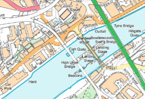
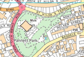
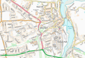
OS VectorMap Local
A highly-detailed, customisable, street-level vector map at 1:10,000 scale, showing physical boundaries around properties, building outlines, paths and street names, for the accurate lie of the land.
Product DetailsOS VectorMap Local is a vector mapping dataset designed to provide contextual mapping outputs. Generated from large-scale source data OS VectorMap Local is ideally suited for applications where 1:10,000 raster backdrop mapping would have previously been used.
VectorMap Local offers the user the flexibility to turn on and off layers of mapping and to style the data as required, allowing the user to create custom maps highlighting their features of interest. Purchasable as a user defined area and deliverable in a range of GIS and CAD formats VectorMap Local is viewable and printable at a variety of scales. The product contains the following features:
• buildings, structures and leisure areas
• roads, paths and tracks
• vegetation and surface features
• water features and associated detail
• railways and associated detail
• spot height
• archaeological and antiquity information
• text
• miscellaneous information – remote areas, foot bridges, house names and all buildings.
Licence: PDF
Technical Details
- Supplier
- Ordnance Survey
- Update Cycle
- Quarterly
- Coverage
- GB
- Scale
- 1:10,000
- Formats Available
- SHP, TAB, GML, DWG
- Stated Accuracy
- Stated Accuracy
- Stated Accuracy
- Licence Options
- Annual
- Delivery Timescale
- Within minutes
Related Products
Download Samples
OS VectorMap Local Raster
Raster version of the popular OS VectorMap Local®, ideal as a backdrop image for engineering, environmental and landscape design projects.
Product DetailsOS VectorMap Local Raster replaces OS 1:10,000 colour raster and is designed for providing contextual mapping output, generated from large-scale source information. It is available as both colour and black and white in a range of raster formats.
The product contains the following features:
- buildings, structures and leisure areas
- roads, paths and tracks
- vegetation and surface features
- water features and associated detail
- railways and associated detail
- spot height
- archaeological and antiquity information
- text
- miscellaneous information – remote areas, foot bridges, house names and all buildings
Also available as a non-georeferenced image.
Licence: PDF
Technical Details
- Supplier
- Ordnance Survey
- Update Cycle
- Quarterly
- Coverage
- GB
- Scale
- 1:10,000
- Formats Available
- PNG, TIFF, JPG, BMP
- Stated Accuracy
- Stated Accuracy
- Stated Accuracy
- Licence Options
- Annual
- Delivery Timescale
- Within minutes
Related Products
Download Samples
OS Open Map Local
OS Open Map – Local is the most detailed, street-level vector mapping product available as open data. It's a great backdrop over which to display your data. 1:10,000 scale
Product DetailsOS Open Map – Local is the most detailed, street-level mapping product available as open data. It's a great backdrop over which to display your data.
Licence: PDF
Technical Details
- Supplier
- Ordnance Survey
- Update Cycle
- Coverage
- GB
- Scale
- 25cm resolution
- Formats Available
- Stated Accuracy
- Stated Accuracy
- Stated Accuracy
- Licence Options
- Delivery Timescale
Related Products
Download Samples
OS Open Map Local Raster
OS Open Map Local Raster is a raster version of the most detailed, street-level mapping product available as open data. It's a great backdrop over which to display your data. 1:10,000 scale
Product DetailsOS Open Map Local Raster is the most detailed, street-level mapping product available as open data. It's a great backdrop over which to display your data.
Licence: PDF
Technical Details
- Supplier
- Ordnance Survey
- Update Cycle
- Coverage
- GB
- Scale
- 25cm resolution
- Formats Available
- Stated Accuracy
- Stated Accuracy
- Stated Accuracy
- Licence Options
- Delivery Timescale