
An increase in rainfall, an increase in insight
If your property has been affected by recent flooding or storms then, for now, you’re probably not interested in deciding what should be to blame: shoddy workmanship or climate change. It’s more important to focus on getting back to normality. It’s probably also no recompense that information about the extent of damage in your area is, perversely, very useful information when it comes to planning future risk mitigation. The question is, how can we make sure the right people are using that data effectively, as soon as possible?
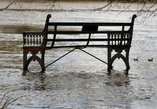
Since 1998, the United Kingdom (UK) has experienced seven of the ten wettest years on record. In fact, the winter storms of December 2015 and January 2016 are considered the most extreme period of intense rainfall ever recorded, causing widespread flooding with the greatest impact felt in northern England. How do we know this? Data. Hard (wet) data. But flood damage itself comes in many forms: there’s far more to ‘recovering from a flood’ property than mopping up or wringing out. A flood may cause hardship and mental anguish for families, and a loss of business – current and future – for commercial enterprises. There’s never been a greater need to make sure we’re using flood data properly, with as many stakeholders as possible factoring it into their analysis.
When we partnered with a hazard-modelling specialist, JBA Risk Management, our aim was to provide insurers with seamless, on-demand data. Data about risks to property, in particular. Today though, we’re getting enquiries not just from insurers, surveyors, loss adjusters and re-insurers, but also from other professionals, all of whom want to use the best possible flood risk analysis in their work.
Claims management, for example, extends beyond the material costs of rebuild and repair. Mental health professionals (and any team involved in caring for the vulnerable), can derive benefit from insights about future risks of flooding in the context of potential impact to a family home or on a business and a livelihood. We must not trivialise the importance of such insight, marginal though it may be.
Flood-risk data is essential for venture capital enterprises, backing new-build construction and infrastructure. It’s less about assessing the immediate risk to a project through its location on a river-bank. Such risks are obvious. It’s more about understanding the ‘upstream’ – literally – impact of flooding on network connections; road and rail infrastructure; employees, travelling to work, and the eco-system around a development.
The weather affects us all, in many different ways. Our postcode-based perils model enables professionals from all sectors – particularly in insurance, of course – to assess windstorm and flooding risk right across the UK. This includes:
- Annual Damage Ratio (ADR) data, which quantifies a measure of risk for pricing purposes – looking at risks from river, coastal and surface water flooding, in addition to wells, against addressing data from Ordnance Survey.
- The Europe Flood Map (EFM) and the Global Flood Map (GFM), both offering deeper, wider risk insights. The GFM offers data on watercourses (and depth of water) internationally, while the EFM services data from 13 European countries, showing undefended hazards at up to 10m resolution.
We know there’s an increasing demand for cost-effective, location-based analysis of this kind recent years and we’ve put the hard work in to partner with experts who can help us deliver that information. Accurate, insightful, layers of data that can be easily visualised and interpreted by standard modelling tools – or delivered as bespoke datasets for a specific integration with a niche outcome. ‘mash-ups’ of client-specific content for in-house accumulations, visualisations, and dashboards.
In recent weeks, the winds have risen, and so have the waters. High street shops were under water within hours. Storms Ciara and Dennis brought heavy rain and winds of more than 90mph, knocking out power and leaving many people ‘in the dark’ about what to expect as climate changes over the next few years.
We’re definitely facing some unknowns about the future. The need to derive more valuable insights and to understand location in greater detail has never been important. It’s the cornerstone for mitigating against risks, and the foundation for building stronger, more resilient housing, networks, society, and infrastructure.
Click here to find out more about Perils and Risk Data from emapsite
Latest News
OS NGD Explained: A beginner’s guide to Ordnance Survey’s National Geographic Database
Learn what the OS National Geographic Database (OS NGD) is, how it works, and why it matters. A simple guide to Britain’s next-generation geospatial data platform.
Read Full Article-
UK geospatial data licensing - A practical guide | Emapsite
Read Full Article -
Six Location Data Challenges for Consultancies | Emapsite
Read Full Article