
Rising waters, rising stakes: Why futureproofing assets against flooding is critical for Britain
A recent investigation by The Guardian has revealed a sobering reality: millions more properties across Britain are now at risk of flooding as climate change intensifies. This makes it more crucial than ever to act - and to ensure those actions are guided by reliable, high-quality data.
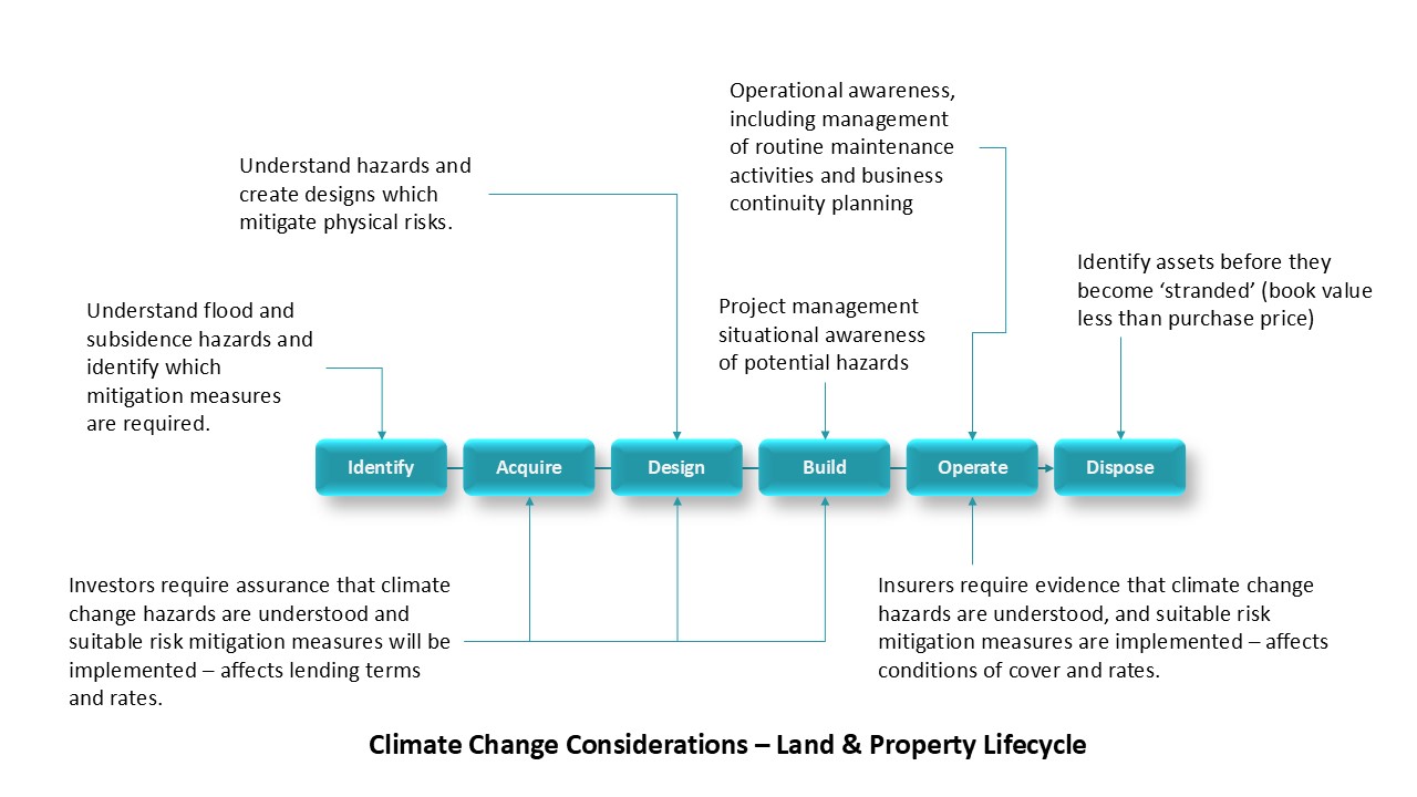
The flood crisis: a growing threat to Britain’s future
Climate change is reshaping the way we think about the landscape. With annual flood damage already costing the UK over £1 billion a year, the urgency to futureproof homes, businesses, and infrastructure has never been clearer. However, the quality of data guiding those decisions directly affects how easily mitigation projects can be costed, designed, and delivered.
According to The Guardian, “Every constituency in Great Britain is projected to have increased flood risk in the future”. The article focused heavily on the possibility that some areas of Britain may eventually have to be abandoned if the cost of protection becomes too high. Scaremongering? No - a timely reality check and a reminder that flood risks are growing in both scale and significance.
For homeowners, businesses, and local authorities, the stakes are immense - floods don’t just damage property; they erode property values, disrupt supply chains, and strain public services. By leveraging the right predictive data, stakeholders can shift from reactive recovery to a model that focuses on proactive mitigation, saving money and preserving livelihoods and communities in the process.
The role of data in futureproofing against floods
High-quality datasets provide a strong foundation for mapping current flood zones and projecting future vulnerabilities with confidence. That certainty is vital, as datasets show the UK is likely to receive more heavy rain more frequently - by as much as 20-30% in the coming decades.
Such resources help identify at-risk areas, from urban centers to rural floodplains, and inform policies such as flood defence investments or land-use planning. Granular, up-to-date, and verified data is critical for actionable insights. As part of that solution, Idox Geospatial is already a trusted provider of flood risk mapping and data to FTSE 100 companies, insurers, and over 4,000 UK businesses.
Idox Geospatial helps clients to raise their data game
Through partnerships with experts such as JBA Consulting and Haskoning (Twinn, formerly Ambiental), we provide data solutions that leverage UKCP data and sophisticated modelling outputs - taking care of the complex data management processes that turn raw information into ready-to-use, actionable insights. Data solutions that help deliver detailed flood models for surface water, rivers, and coastal risks across Britain. Coupled with our customer-focused, responsive approach to service delivery, this makes Idox Geospatial an ideal data partner.
The datasets provide climate-adjusted projections for the 2020s, 2050s, and 2080s under various emissions scenarios, offering property-level insights into flood depths and probabilities for both defended and undefended areas. Available via web services, automated reports, or bespoke analyses, this data empowers all stakeholders in the property lifecycle to make informed decisions, from siting new developments to pricing insurance policies.
The true value of granular, verified, up-to-date data
Why invest in premium datasets like these? The answer lies in their precision, reliability, and currency - qualities that translate directly into risk mitigation. These can transform flood risk management from a gamble into a science:
Pinpoint-accuracy for targeted interventions: Property-level data that identifies specific vulnerabilities, such as a building’s exposure to a 1-in-100-year flood event. This enables tailored retrofitting, such as raising electrical systems or installing flood barriers, reducing potential damage costs.
Robust scenario-planning for future risks: Updated with events like Storm Babet, climate-adjusted models simulate flood risks across multiple timeframes and emissions scenarios. This helps developers avoid high-risk sites and businesses to plan phased relocations, protecting asset values as flood frequency rises.
Cost-efficient resource allocation: Up-to-date data helps prevent the errors that can arise from outdated mapping. For local authorities, this means greater confidence in prioritising green infrastructure in high-risk zones, and reducing flood management costs by 15-20% compared to reactive repairs.
Regulatory and investor assurance: As auditable, verified data, our datasets align with national standards, which adds efficiency to the process and streamlines planning approvals. For urban developers and planners, that means fewer delays; for investors, it means more confidence.
Streamlined emergency response: Granular data, such as depth and velocity estimates, integrates with forecasting systems for rapid response planning. This can help minimise downtime - critical when a single flood might erase 20% of a small firm’s annual revenue - by enabling faster evacuations and aid deployment.
Building a flood-resilient future
By integrating advanced datasets, we help stakeholders across the property lifecycle to futureproof assets with precision, protecting communities and economies from the rising tide. Whether you’re a homeowner, developer, or policymaker, the time to act is now.
Ready to assess your flood risks?
Explore our Flood Risk Mapping Solutions today.
Emapsite is a trading name of Idox Geospatial
Latest News

Six Location Data Challenges for Consultancies | Emapsite
Location data is critical to consultancy work, yet common issues like outdated datasets, licensing uncertainty, and incompatible formats can slow projects down and increase risk. This infographic explores six of the most frequent location data challenges faced by consultancies today — and how teams are overcoming them with reliable, compliant, and easy-to-use spatial data.
Read Full Article-
Future-proofing Assets Against Flooding in Britain
Read Full Article -
Why address data is the unsung hero in the UK’s new-build recovery
Read Full Article