
Geological Data
Ground conditions, subsurface perils, boreholes, rock, minerals, aquifers, coal mining - subsurface data for your analysis.
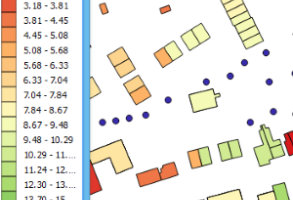
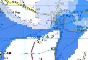
Emapsite Subsidence Risk
Subsidence Risk gives a detailed perspective into residential subsidence risk on an individual property basis using the latest geology and tree data.
Product DetailsIn liaison with the Insurance industry and exclusive to emapsite, Subsidence Risk has been purpose-designed to provide a more granular level of risk insight for Insurers, moving away from traditional postcode-based analysis to individual property level, driven by the knowledge that up to 70% of subsidence claims are tree-related. Insurers can benefit from the currency and level of detail in Subsidence Risk data and have greater confidence in the rationale behind risk selection, valuation, pricing and accumulation decisions.
Subsidence involves underlying earth movement as distinct from property settlement which is generally indicative of poor design or construction. As climatic changes grow more and more unpredictable, both locally and globally, issues around underlying ground stability, planning history and historic land use will continue to impact on insurance-related decisions.
Key to the product are IT system-ready property reference tables containing a normalised risk score for every property address enabling insurers to enhance their existing view of high and low risk areas and adjust their underwriting and claims policies accordingly. It also provides insight into areas where insurers have little or no claims data, enabling refinement of underwriting in all areas. Risk analysts, underwriters and actuaries can rate risk at individual property level to make optimal pricing and portfolio decisions.
For ease of use by Insurer systems, the dataset is available as a webservice from the emapsite Perils data hub.
Technical Details
- Supplier
- emapsite
- Update Cycle
- Ad-hoc
- Coverage
- England, Scotland and Wales
- Scale
- Formats Available
- CSV or webservice
- Stated Accuracy
- Stated Accuracy
- Stated Accuracy
- Licence Options
- Annual
- Delivery Timescale
- On request
Related Products
OS MasterMap Topography Layer, AddressBase Plus
Download Samples
No sample downloads are currently available for this product
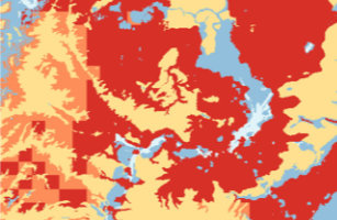
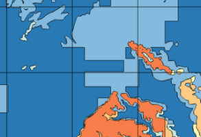
BGS - GeoClimate 18
GeoClimate18 is a new vector product designed to help you assess the future change in susceptibility of natural clay "shrink-swell" across Great Britain as a result of climate change.
Product DetailsGeoClimate 18 uses Met Office UK Climate Prediction UKCP18 climate data (high-emissions scenario; RCP8.5) to indicate the likelihood that foundations will be affected by wetter, average and drier conditions centred on 2030 (2025-2035) and 2070 (2065-2075).
The product provides a ‘hot spot’ map of susceptible areas in order to:
- - aid risk reduction
- - save time associated with manual site visits
- - inform future requirements for changes in the design of foundations
- - minimise potential losses from rebuild and disruption
- - prioritise works and remedial action
- - inform mitigation strategies
GeoClimate18 combines current GB clay shrink-swell hazard susceptibility, GB groundwater modelling and climate change projections. Twelve soil moisture projections are sorted from wettest to driest at every location, and the 10th, 50th and 90th percentile calculations provide the wetter, average and drier projections. The ‘extreme’ projections convey the variation and uncertainty within the scenario modelling and allow customers to consider the best-case and worst-case scenario for shrink-swell susceptibility.
Who is the product for?
Natural ground stability hazards and the potential impacts of climate change are of interest to anyone involved in the ownership or management of property and those required to plan for longer-term resilience into the 21st Century. This includes planners, architects, surveyors, developers, lenders, consulting engineers, builders, insurers and loss adjustors in many industries (e.g. construction, insurance, road/rail infrastructure, utility companies).
Why is the product important?
Understanding the likelihood of ground instability (subsidence) now and in the future can assist in identifying areas with potential problems and aid development planning by helping to define land suited to different uses. Ground instability hazards could result in increased insurance premiums, depressed house prices/property portfolio values and, potentially, require corrective engineering works.
Technical Details
- Supplier
- British Geological Society
- Update Cycle
- Coverage
- Great Britain
- Scale
- Formats Available
- Vector polygons in ESRI SHP or GDB
- Stated Accuracy
- Stated Accuracy
- Stated Accuracy
- Licence Options
- Annual
- Delivery Timescale
Related Products
BGS Geology 10k & 50, Groundsure Geo Insight, OS VectorMap Local, OS VectorMap Local Raster, OS 1:50 000 Raster
Download Samples
Samples coming soon.....
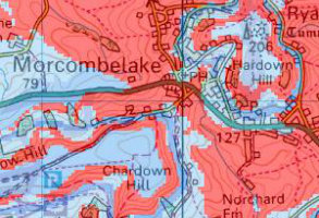
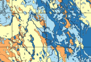
BGS GeoSure
DigMapGB-50 geology translated into 6 perils layers - swell-shrink, slope instability, dissolution, compressible deposits, collapsible deposits and running sands.
Product DetailsThe BGS GeoSure datasets identify areas of potential hazard and, therefore, potential natural ground movement, in Great Britain. These data have been produced by BGS geologists and geotechnical specialists and are presented as six GIS data layers relating to the cause of the geohazard:
* Collapsible deposits: Some types of ground can collapse when a load (such as a building or road traffic) is placed on them and when they become saturated. Such collapse may cause damage to overlying property.
* Shrink-swell: Some types of ground can change volume due to variation in moisture. The changing volume can cause ground movement which could potentially affect building foundations, pipes or services.
* Compressible ground: Some types of ground can contain layers of very soft materials like clay or peat. These may compress if loaded by overlying structures, or if the groundwater level changes, potentially resulting in depression of the ground and disturbance of foundations.
* Landslides: Some types of ground may be susceptible to a landslide hazard. Downslope movement of materials, such as a landslide or rockfall may lead to a loss of support and damage to buildings.
* Running sand: Some types of ground can contain loosely packed sandy layers that can become fluidized by water flowing through them. Such sands can 'run', removing support from overlying buildings and causing potential damage.
* Soluble rocks: Some types of ground contain layers of material that can be dissolved by water. This can cause underground cavities to develop. These cavities reduce support to the ground above and can lead to a collapse of overlying material.
Technical Details
- Supplier
- British Geological Survey
- Update Cycle
- Coverage
- GB
- Scale
- 1:50,000
- Formats Available
- SHP, TAB
- Stated Accuracy
- Stated Accuracy
- Stated Accuracy
- Licence Options
- Annual
- Delivery Timescale
- Within minutes
Related Products
emapsite Subsitree with NTM, Groundsure Geo Insight, OS 1:50 000 Raster
Download Samples
BGS Geology 10k
Generalised digital geological map data based on BGS's New Series 1:50 000 and 1:63 360 scale maps with updated nomenclature.
Product Details
Geology maps are the foundation for many other types of earth science related maps and are of potential use to a wide range of customers.
This product is available at 1:10,000.
The geological areas (or polygons) are labelled or attributed with a name (based on their lithostratographical, chronostratographical or lithodemic nomenclature) and their composition (rock type or lithology). This information is arranged in up to four themes as available: bedrock geology; superficial deposits; mass movement; and artificial ground. Faults and other linear features are available in a separate theme.
Technical Details
- Supplier
- British Geological Survey
- Update Cycle
- Coverage
- Most of GB
- Scale
- 1:10,000
- Formats Available
- SHP, TAB
- Stated Accuracy
- Stated Accuracy
- Stated Accuracy
- Licence Options
- Annual
- Delivery Timescale
- Within minutes
Related Products
Groundsure Geo Insight, OS VectorMap Local, OS VectorMap Local Raster, OS 1:50 000 Raster
Download Samples
BGS Geology 50k
Generalised digital geological map data based on BGS's New Series 1:50 000 and 1:63 360 scale maps with updated nomenclature.
Product Details
Geology maps are the foundation for many other types of earth science related maps and are of potential use to a wide range of customers.
This product is available at 1:50,000 scale
The geological areas (or polygons) are labelled or attributed with a name (based on their lithostratographical, chronostratographical or lithodemic nomenclature) and their composition (rock type or lithology). This information is arranged in up to four themes as available: bedrock geology; superficial deposits; mass movement; and artificial ground. Faults and other linear features are available in a separate theme.
Technical Details
- Supplier
- British Geological Survey
- Update Cycle
- Coverage
- Most of GB
- Scale
- 1:50,000
- Formats Available
- SHP, TAB
- Stated Accuracy
- Stated Accuracy
- Stated Accuracy
- Licence Options
- Annual
- Delivery Timescale
- Within minutes
Related Products
Groundsure Geo Insight, OS VectorMap Local, OS VectorMap Local Raster, OS 1:50 000 Raster
Download Samples
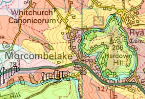
BGS Groundwater Flooding
Groundwater flood risk types are shown as graded polygons and attributed as either "superficial deposits flooding" or "clearwater flooding".
Product DetailsGroundwater flooding is the emergence of groundwater at the ground surface. It can occur in a variety of geological settings including valleys in areas underlain by Chalk, and in river valleys with thick deposits of alluvium and river gravels. Groundwater flooding happens in response to a combination of already high groundwater levels (usually during mid- or late-winter) and intense or unusually lengthy storm events. Groundwater flooding often lasts much longer than flooding caused by a river over-flowing its banks. It may last many months and can cause significant social and economic disruption to the affected areas.
Data is available in Shapefile or Tab file format. Groundwater flood risk types are shown as polygons and attributed as either "superficial deposits flooding" or "clearwater flooding", and are graded into 5 categories from Very Low to Very High.
Technical Details
- Supplier
- British Geological Survey
- Update Cycle
- Coverage
- GB
- Scale
- 1:50,000
- Formats Available
- SHP, TAB
- Stated Accuracy
- Stated Accuracy
- Stated Accuracy
- Licence Options
- Annual
- Delivery Timescale
- up to 4 working hours
Related Products
JBA Comprehensive Flood Model, Groundsure Enviro Insight, OS 1:50 000 Raster
Download Samples
BGS Radon Potential
This HPA-BGS radon potential dataset is for use in GIS software.
Product DetailsThe data can be used to answer one of the standard legal enquiries on house purchase in England and Wales (CON29 Standard Enquiry of Local Authority: 3.13 Radon Gas: Location of the Property in a Radon Affected Area). It also provides information on the level of protection required for new dwellings under BR211 (2007) Radon: guidance on protective measures for new buildings.
Please contact us at sales@emapsite.com for further details or a quote.
Technical Details
- Supplier
- British Geological Survey
- Update Cycle
- Coverage
- UK
- Scale
- 1:50,000
- Formats Available
- SHP, TAB
- Stated Accuracy
- Stated Accuracy
- Stated Accuracy
- Licence Options
- Annual
- Delivery Timescale
- within 4 working hours
Related Products
Download Samples
BGS Borehole Index
The Single Onshore Borehole Index (SOBI) is an index of over 1 million records of boreholes, shafts and wells from drilling and site investigation work.
Product DetailsThe collection covers onshore and near shore boreholes from Great Britain dating back to at least 1790 and ranging from one to several thousand metres deep. Some 50,000 new records are added each year. The majority of the records contain written descriptions of the ground encountered.
The SOBI index database originated in 1988 from a number of existing tables and from data input from a variety of coding forms. Therefore not all fields in the database are populated and data that should be in some fields may currently form part of the entries in another.
Please contact us at sales@emapsite.com for further details or a quote.
Technical Details
- Supplier
- British Geological Survey
- Update Cycle
- Coverage
- GB
- Scale
- Formats Available
- SHP, TAB
- Stated Accuracy
- Stated Accuracy
- Stated Accuracy
- Licence Options
- Open
- Delivery Timescale
- within 4 working hours
Related Products
Download Samples
BGS Permeability
GB-wide 1:50,000 scale hydraulic conductivity (permeability) data.
Product DetailsPermeability values indicate the vulnerability of the rock to groundwater pollution from the surface and are a measure of the fastest route by which any pollutant could travel through rocks and enter the underground water resource.
Maximum and minimum permeability indices are given for each geological unit to indicate the range in permeability likely to be encountered and the predominant flow mechanism (fracture or intergranular). Neither of the assigned values takes into account the thickness of either the unsaturated or saturated part of the lithostratigraphical unit. The data is best displayed using GIS, and is available in vector format as ESRI shapefiles and MapInfo TAB files. Please contact us at sales@emapsite.com for further details or a quote.
Technical Details
- Supplier
- British Geological Survey
- Update Cycle
- Coverage
- GB
- Scale
- 1:50,000
- Formats Available
- SHP, TAB
- Stated Accuracy
- Stated Accuracy
- Stated Accuracy
- Licence Options
- Annual
- Delivery Timescale
- within 4 working hours
Related Products
Download Samples
SHP (Showing four of possible four layers available, location depending)