
OS MasterMap Highways Network
OS MasterMap Highways Network® is data you can trust. It draws on authoritative sources and helps underpin the common operational picture that leads to faster, better decisions.
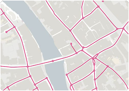
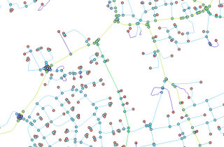
OS MasterMap® Highways Network is the most complete, detailed and accurate routable road network dataset for Great Britain. It records the dimensions and accessibility of roads.
OS MasterMap Highways Network - Roads
Available as a stand alone product, OS MasterMap Highways Network - Roads combines high-quality, accurately surveyed data with features from the National Street Gazetteer; the Local Highways Authorities road name, numbering and maintenance; the Trunk Road Street Gazetteer collected by Highways England and Welsh Government; and the Scottish Street Gazetteer containing information from Scottish local authorities and Transport Scotland.

OS MasterMap Highways Network - Paths
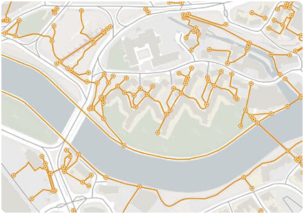
Available as a stand alone product, this is a path network dataset for Great Britain showing who is responsible for all the footpaths through towns and cities.
The dataset helps you understand how people connect to towns and cities around them. You will see the true time it takes for the citizen to access existing services – as well as the new services required in the community.
OS MasterMap Highways Network - Paths is a collection of data from authoritative sources who manage and maintain the network within our towns and cities. This includes OS path network geometry and features the local highways and roads authorities’ name, numbering and maintenance responsibility information.
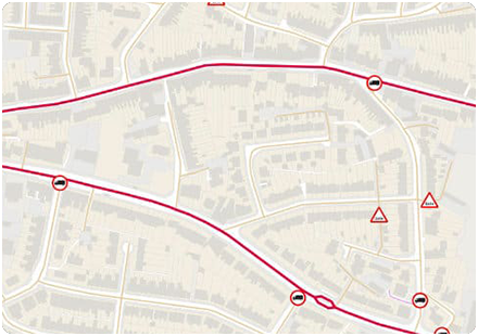
OS MasterMap Highways Network - Routing and Asset Management
This product is for vehicle routing and navigation software providers, this data gives you all you need to get your users safely to their destinations: turn, height, weight and width restrictions – and even bollards and traffic calming.
OS MasterMap Highways Network - Routing & Asset Management Information includes our highly accurate road network geometry and associated routing restriction information for detailed route planning and network analysis.
The Ordnance Survey asset management information allows highways teams to improve planning schemes in the office, avoiding unnecessary site visits. It can also identify potentially difficult locations, so you can organise required permits in good time.
OS MasterMap Highways Network with Speed Data
Samples available soon
Speed data helps to plan routes, analyse traffic information and optimise journeys.
The speed data products are provided as additional files for use in conjunction with the OS MasterMap Highways Network – Routing and Asset Management Information product.
- OSMM Highways Network with RAMI and Average Speed
- OSMM Highways Network with RAMI and Speed Limits
- OSMM Highways Network with RAMI and Average Speed and Speed Limits
Access road speed limits and average speed with our additional highways datasets, to plan logistics and monitor and optimise routes more effectively.
Develop speed limiter technology for autonomous vehicles, or design customisable sat nav systems with access to speed limit and average speed datasets.
These 3 products link to the corresponding road link feature and TOID/unique identifier.
OS MasterMap Highways Network
OS MasterMap Highways Network provides an authoritative view of the whole road network in Great Britain, ideal for routing and public sector data-sharing.
Product DetailsOS Mastermap Highways Network is the Ordnance Survey's latest and most comprehensive dataset of Great Britain's road network and is the next generation of the well-known product OS ITN. It is comprised of a suite of products that brings together the best information from authoritative sources in to one central location.
In addition to road centre lines and classifications, Highways features richer content that is better structured to allow for analysis as well as visualisation. Highways has been designed with traffic analysis, asset management, planning and the emergency services in mind, allowing users to plan for tomorrow. It gives you accurate and precise asset management information on who maintains the road network and the type of surface reinstatement values. And it's a valuable reporting tool, for key facts and statistics about the road, against a consistent and authoritative base.
OS Highways - Roads can be extended using OS Highways - Routing, and OS Highways - Paths
OS Highways - Roads attribution includes:
- road classification, naming and numbering
- vehicle restrictions
- links to OS Addressbase and the USRN
- roads under construction
- public/private maintained roads
- special engineering difficulty
- special event information
- road hazards: overhead structures, level crossings, movable bollards, gates
- protected streets
- traffic sensitive roads
OS Highways - Routing additionally includes:
- turn restrictions
OS Highways - Paths additionally includes:
- links between roads/paths
Technical Details
- Supplier
- Ordnance Survey
- Update Cycle
- Coverage
- GB
- Scale
- 1:1250
- Formats Available
- Stated Accuracy
- Stated Accuracy
- Stated Accuracy
- Licence Options
- Delivery Timescale
Related Products
Complementary Data
OS Mastermap Imagery Layer, Lidar, AddressBase Plus
Download Samples
OS MasterMap Highways Network - Paths
OS MasterMap Highways Network provides an authoritative view of the whole road network in Great Britain, ideal for routing and public sector data-sharing.
Product DetailsOS MasterMap® A path network dataset for Great Britain showing who is responsible for all the footpaths through towns and cities. The dataset helps understand how people connect to towns and cities around them. Unique Street Reference Number (USRN) links this data AddressBase datasets for Search or Navigation.
Technical Details
- Supplier
- Ordnance Survey
- Update Cycle
- Coverage
- GB
- Scale
- 1:1250
- Formats Available
- Stated Accuracy
- Stated Accuracy
- Stated Accuracy
- Licence Options
- Delivery Timescale
Related Products
Complementary Data
OS Mastermap Imagery Layer, Lidar, AddressBase Plus
Download Samples
OS MasterMap Highways Network - Roads and Routing
OS MasterMap Highways Network - Roads and Routing provides detailed road geometry and routing restrictions for accurate route planning and asset management in Great Britain.
Product DetailsOS MasterMap® Provides OS road network geometry and associated routing restriction information for detailed route planning and network analysis. RAMI is an extended part of the Highways Network suite of data including turn, height, weight and width restrictions, bollards and traffic calming.
Technical Details
- Supplier
- Ordnance Survey
- Update Cycle
- Coverage
- GB
- Scale
- 1:1250
- Formats Available
- Stated Accuracy
- Stated Accuracy
- Stated Accuracy
- Licence Options
- Delivery Timescale
Related Products
Complementary Data
OS Mastermap Imagery Layer, Lidar, AddressBase Plus
Download Samples
OS MasterMap Highways Network - Routing and Asset Management: SHP
Buy OS MasterMap Highways Network - Roads and Asset Management >

Unrivalled resources
We simplify the supply and management of mapping products, plans and reports. Blending diverse datasets to uncover hidden commercial insights.

Business intelligence
Our spatial intelligence enables our clients to pinpoint areas of risk and reward, and to make better business decisions faster.

Proven partnership
We work in partnership, we're supportive, and we're committed to reducing our own and our clients' impact on the environment.