Renewables
Experts in renewables mapping and data
On and offshore, emapsite is the place for renewables-related location data, mapping, and business location insights.
Renewables are the future, but the challenge is in the present. We provide authoritative mapping for the renewables sector.
Onshore and offshore wind energy, solar power, tidal power, nuclear construction, network infrastructure, site finding, utilities connectivity and more.
What do we offer?
We offer the raw location data, mapping, planning insights and expertise to support all construction and maintenance in the renewables sector.
- - Our download location data formats support CAD and GIS.
- - We have online mapping for renewables and dashboards that deliver mapping software for renewables too.
- - And we have the ideal datasets for renewables' site analysis and identification.


Renewables are the future
For mapping, modelling, environmental analysis, understanding subsurface assets, land ownership and use, and marine information.
Emapsite has all the renewables' mapping and data you need.
- Site Investigation - licensing support and access to OS MasterMap.
- Marine data and mapping - we can offer the full marine data package.
- Site intelligence - historic mapping, geology, flood, utilities and radar risk reports.
- Site Selection - rights of way, OS VectorMap Local Raster and more.
- National/Regional Planning - feasibility, terrain modelling, obstructions data.
- High Resolution Imagery - off the shelf or bespoke outputs for detailed insights.
- National Tree Map (NTM) - every tree in England and Wales.
- Building Heights - 3D modelling and height data, enabling visual assessments.
- OS OpenData - download up to date OS OpenData.
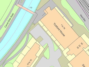
OS MasterMap Topography Layer
OS MasterMap Topography Layer is the most detailed and accurate view of Great Britain's landscape – from roads to fields, to buildings and trees, fences, paths and more.
Product DetailsOS MasterMap is the most detailed, current and comprehensive map dataset of Great Britain, enabling you to make better decisions and manage your assets more effectively. Working with the other mapping layers in the suite, OS MasterMap Topography Layer gives you the visual context to help interpret addresses, routes and imagery. OS MasterMap is the approved dataset for planning applications and land registration.
Continually updated, OS MasterMap contains 450 million geographic features found in the real world, from detailed building and road outlines to water features, pathways, bus shelters and letter boxes.
Licence: PDF
OS MasterMap is ideal for:
- Use in CAD or GIS
- Planning
- Site location and evaluation
- Risk management
- Transport and infrastructure
- Asset management
- Environmental analysis
Technical Details
- Supplier
- Ordnance Survey
- Update Cycle
- 6 weekly
- Coverage
- GB
- Scale
- 1:1250
- Formats Available
- DWG, SHP, GML, TAB, DXF, GDB, KML, TIFF
- Stated Accuracy
- Urban +/- 1m
- Stated Accuracy
- Rural +/- 8m
- Stated Accuracy
- +/- 8m
- Licence Options
- 12, 24 or 36 months
- Delivery Timescale
- Within minutes
Related Products
PDF Plans, Aerial Photography, OS MasterMap Highways Layer, OS Mastermap ITN, OS Mastermap Imagery Layer, Lidar, AddressBase Plus
Download Samples
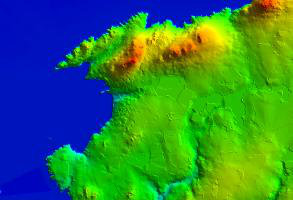
OS Terrain 5
OS Terrain 5 is a Digital Terrain Model (DTM) showing the bare surface of the ground, without vegetation or buildings and is ideal for 3D modelling.
Product DetailsIt offers detailed modelling of significant features such as road, rail, quarries and lakes allowing you to asses the lie of the land on-screen and reduce the need for site visits. OS Terrain 5 has a root mean square error (RMSE) value of 1.5 metres in urban areas and major communication routes.
OS Terrain 5 is maintained as part of the same revision process as the Ordnance Survey's large scale datasets and so adds a valuable third dimension to OS MasterMap Topography Layer.
Licence: PDF
OS Terrain 5 is ideal for:
OS Terrain 5 is particularly valuable for large scale development projects, planning, impact assessment
Technical Details
- Supplier
- Ordnance Survey
- Update Cycle
- 6 weekly
- Coverage
- GB
- Scale
- 5m resolution
- Formats Available
- ASC, XYZ, TXT, DXF
- Stated Accuracy
- Stated Accuracy
- Stated Accuracy
- Licence Options
- Annual
- Delivery Timescale
- Within minutes
Related Products
Aerial Photography, OS MasterMap Topography Layer, OS VectorMap Local
Download Samples
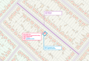
AddressBase Core
Local Authority data is at the heart of AddressBase Core. Providing you with a complete address data product & ensuring access to granular detail when compared to the alternative - delivery points.
Product DetailsAddressBase Core makes it easier to locate, match and gain insights from other location data with the benefit of having key identifiers referenced throughout. The Unique Property Reference Number (UPRN), Unique Street Reference Number (USRN) and Topographic Identifier (TOID) allow users to reference to other OS products.
Third party identifiers such as the Unique Delivery Point Reference Number (UDPRN) and Government Statistical Service (GSS) Code are also included, so you're more likely to be able to confidently bring multiple sources together using one of the key identifiers included in this dataset.
Making the most of the property classification attributes, you can quickly understand, locate and perform analysis on the type of addresses you want to interact with.
You don’t need to use it all - only need residential addresses, commercial addresses or even just schools? No problem - AddressBase Core can do that too!
Licence: PDF
Technical Details
- Supplier
- Ordnance Survey
- Update Cycle
- Fortnightly
- Coverage
- Great Britain
- Scale
- 1:10 – 1:10 000
- Formats Available
- Comma separated value (CSV) or SHP
- Stated Accuracy
- Stated Accuracy
- Stated Accuracy
- Sub-metre
- Licence Options
- Annual
- Delivery Timescale
- Within minutes
Related Products
Download Samples
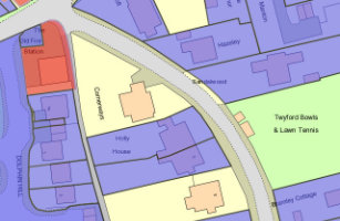
Emapsite LandPack Title and Tenure
OS MasterMap enriched with HM Land Registry Polygons, along with additional property information such as property type, construction age and EPC data.
Product DetailsEmapsite LandPack Title and Tenure provides Emapsite LandPack Polygons plus OS MasterMap Topography Layer for a customer's area of interest. The product indicates freehold and leasehold polygons and areas where no data is held (perhaps because ownership information is held in paper deeds, by a mortgage provider/solicitor or there is no owner) along with property information such as property type, built form and construction age plus current energy consumption, rating, efficiency and carbon dioxide (CO2) emissions.
There may be more than one polygon per Title (e.g. where a house with a garden has a garage located separately).
You can purchase emapsite Land Title and Tenure through our online mapshop, where you can define your area of interest and purchase in a range of GIS formats.
Licence: PDF
Common uses:
Ideal for project and site specific users in a variety of sectors where land parcel information is required, including planning, site development and asset management.
Technical Details
- Supplier
- Update Cycle
- 6-weekly
- Coverage
- England and Wales
- Scale
- 1:1250
- Formats Available
- SHP, GDB, DWG
- Stated Accuracy
- Stated Accuracy
- Stated Accuracy
- Licence Options
- Annual
- Delivery Timescale
Related Products
OS MasterMap Topography Layer, AddressBase Plus
Download Samples
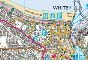
OS 1:25,000 Raster
Ordnance Survey's 1:25,000 scale mapping of GB is the digital version of OS Explorer - ideal for analysing the environment in a rural area.
Product DetailsThe Ordnance Survey's well-known Explorer series of mapping, familiar to walkers and outdoor enthusiasts. Ideal for analysing the environment across a district and in a rural areas, 1:25,000 raster data includes field boundaries, administrative boundaries, Rights of Way including access land, National Trust land, MOD land, selected cycle routes, national trails and points of interest for tourism. Contour lines are shown at 5m intervals (or 10m in some mountainous areas).
The maps can be ordered in a range of raster formats as well as the standard 10x10km TIFF tiles.
The pixel resolution of 1:25,000 data is 2.5m, and printing at 254dpi will print to the correct scale.
Licence: PDF
Technical Details
- Supplier
- Ordnance Survey
- Update Cycle
- Bi-annual
- Coverage
- GB
- Scale
- 1:25,000
- Formats Available
- TIFF, BMP, JPG, PNG
- Stated Accuracy
- Stated Accuracy
- Stated Accuracy
- Licence Options
- Annual
- Delivery Timescale
- Within minutes
Related Products
OS VectorMap District Raster, OS VectorMap Local, OS VectorMap Local Raster
Download Samples
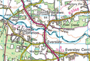
OS 1:50,000 Raster
The 1:50,000 Scale Raster dataset is the digital version of the familiar Ordnance Survey Landranger® map series.
Product DetailsFamiliar to many as the OS Landranger series of paper maps, OS 1:50,000 raster data is also useful for providing context across a wide area and using as a backdrop within GIS or CAD. The maps detail roads, public rights of way, woods, water features, important buildings and contour lines at 10m intervals, and can be ordered in a range of raster formats as well as the standard 20x20km TIFF tiles.
The pixel resolution of 1:50,000 data is 5m, and printing at 254dpi will print to the correct scale.
Licence: PDF
Technical Details
- Supplier
- Ordnance Survey
- Update Cycle
- Bi-annual
- Coverage
- GB plus Isle of Man
- Scale
- 1:50,000
- Formats Available
- TIFF, BMP, JPG, PNG
- Stated Accuracy
- Stated Accuracy
- Stated Accuracy
- Licence Options
- Annual
- Delivery Timescale
- Within minutes
Related Products
Download Samples
Groundsure Insight
The three key Enviro, Geo and Map Insight reports, combining unique environmental and geological datasets with the highest resolution historic mapping available.
Product DetailsGroundsure Insight delivers detailed and accurate information using extensive and unique environmental and geological datasets as well as providing you with the highest resolution historic mapping available.
Groundsure’s Historic Land Use Database (HLUD) is the most accurate and reliable information available on the market. Our HLUD is derived from historic Ordnance Survey mapping dating back to the 1840s, scanned in at over 500dpi – setting a new industry standard.
This sharper imagery means you can see the information more clearly and benefit from greater confidence in your opinion. Each map is manually assessed by an in-house GIS consultant before we deliver it. The Full pack includes National Grid, County Series and Town Plans at scales: 1:10,000, 1:10,560, 1:2,500, 1:1,250, 1:1056 and 1:500.
The Geo Insight report provides all the geo-environmental data required to make informed decisions and identify potential ground stability problems that may affect ground investigation, foundation design or possible remediation options.
What does it cover?
- Historical Land Use information
- Environmental Permits, Incidents and Registers
- Hydrology and Hydrogeology data including abstractions, source protection zones (SPZ), now with SPZ within confined aquifers
- Basic flood data including EA Flood Zones, RoFRaS and groundwater
- Detailed flood mapping – Previously only available in the Flood Insight product
- Groundsure’s unique historical surface and underground workings database
- Groundsure’s mining and mineral extraction database
- Detailed BGS data – 1:10,000 and 1:50,000 scale geology
- BGS non-coal mining hazards data
- BGS BRITPITS current ground workings information
- BGS borehole records, hyperlinked to online BGS scans
- Estimated background soil chemistry information and radon levels.
We can now offer data from your Groundsure Insight reports in vector formats for use in GIS. This gives you the benefit of being able to analyse the information provided in a standard Groundsure Insight PDF report alongside other spatial data. Pricing depends on your area of interest so please contact us for a quote.
Report is available for England, Wales and Scotland. Data sources may differ in Scotland.
Technical Details
- Supplier
- Groundsure
- Update Cycle
- Coverage
- England and Wales
- Scale
- 1:2500 and 1:10,000
- Formats Available
- Stated Accuracy
- Stated Accuracy
- Stated Accuracy
- Licence Options
- Perpetual
- Delivery Timescale
- 4 working hours
Related Products
PDF Plans, OS MasterMap Topography Layer
Download Samples
Utility Essentials
This report gives visibility of the 5 key services – Gas, Electric, Water, Sewage and BT Openreach.
Product DetailsThe Essentials report is collated and delivered in 5 working days* and is ideal for remote sites where only the main utility providers are likely to be present or projects where the aim is merely to check the availability of the main utilities (water/sewer, gas, electric and BT) e.g. in the planning stages of a new development.
*Due to the extensive nature of some searches, the number of utilities searched, and the response timescales imposed by some utility suppliers, it can happen that not all responses are received within the relevant timeframe. When this does occur, your report will be delivered with all available content as requested, and a final report will be delivered as soon as the outstanding information has been received.
Technical Details
- Supplier
- Technics
- Update Cycle
- Coverage
- GB
- Scale
- Formats Available
- Stated Accuracy
- Stated Accuracy
- Stated Accuracy
- Licence Options
- Perpetual
- Delivery Timescale
- 5 working days
Related Products
Download Samples
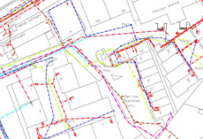
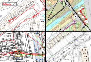
Utility Report Digitised
Your utilities data supplied as digitised CAD layers
Product DetailsDigitising Utilities data into CAD is one of those business-critical but time-consuming jobs that many could well do without, which is why you can opt for us to supply your utilities data as digitised CAD layers.
Data is collected from all relevant service providers and is digitised into CAD layers, supplied as a digital product to be used alongside your Utility Report PDF file. Prices will be quoted individually, but are competitive, and in many cases are cheaper than in-house CAD teams.
We have three different options for levels of detail/information for digitisation: Primary, Intermediated and Advanced. Please contact us for more information on what each includes.
Technical Details
- Supplier
- emapsite
- Update Cycle
- Coverage
- GB
- Scale
- Based on utility plans
- Formats Available
- CAD formats
- Stated Accuracy
- Stated Accuracy
- Stated Accuracy
- Licence Options
- Perpetual
- Delivery Timescale
- On request
Related Products
Download Samples
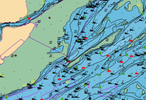
Marine Themes - Large, Medium + Small Scale
Marine Themes comprises authoritative data from the UK & other Hydrographic Offices, engineered into logical data layers for easy loading & efficient GIS use.
Product DetailsMarine Themes - Large, Medium + Small Scale
Created by OceanWise Ltd using data from the UK Hydrographic Office and other agencies. Data derived from Electronic Navigational Charts (ENCs) is used to provide additional coverage.
- Ongoing maintenance schedule to ensure the latest survey data is incorporated.
Licence: PDF
Technical Details
- Supplier
- Oceanwise Ltd
- Update Cycle
- Coverage
- UK waters
- Scale
- Various
- Formats Available
- SHP, TAB
- Stated Accuracy
- Stated Accuracy
- Stated Accuracy
- Licence Options
- Annual
- Delivery Timescale
- within 4 working hours
Related Products
Download Samples
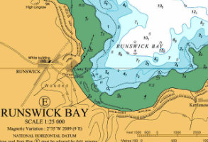
Marine Raster Charts
Familiar nautical chart base map, ready for use in GIS. Small scale charts of seas and regions to large scale charts of harbours and ports.
Product Details
Marine Raster Charts are derived in part from material obtained from the UK Hydrographic Office, supplied as image files for easy loading and use in GIS.The data is supplied in GeoTIFF format at discrete scale levels, cut-out to your chosen area and labelled by Admiralty Chart number for easy referencing. Raster Charts are available worldwide depending on permissions granted by contributing nations.
Licence: PDF
Technical Details
- Supplier
- Oceanwise Ltd
- Update Cycle
- Coverage
- UK waters and selected global charts
- Scale
- Various
- Formats Available
- TIFF
- Stated Accuracy
- Stated Accuracy
- Stated Accuracy
- Licence Options
- Annual
- Delivery Timescale
- within 4 working hours
Related Products
Download Samples
Large, Medium, Small: TIF
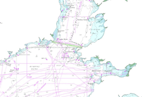
Marine Raster Charts eXcluding Land (XL)
Familiar nautical chart base map, ready for use in GIS with the land removed, ready to be paired with the onshore mapping data.
Product Details
Marine Raster Charts eXcluding Land (XL) are derived in part from material obtained from the UK Hydrographic Office, supplied as image files for easy loading and use in GIS. These charts have had the land removed and are ready to be paired with onshore data. The data is supplied in GeoTIFF format at discrete scale levels, cut-out to your chosen area and labelled by Admiralty Chart number for easy referencing. Raster Charts are available worldwide depending on permissions granted by contributing nations.
Licence: PDF
Technical Details
- Supplier
- Oceanwise Ltd
- Update Cycle
- Coverage
- UK waters and selected global charts
- Scale
- Various
- Formats Available
- TIFF
- Stated Accuracy
- Stated Accuracy
- Stated Accuracy
- Licence Options
- Annual
- Delivery Timescale
- within 4 working hours
Related Products
Download Samples