

Plans Ordering Platform
-
- For typical planning compliant 1:1,250 Location and 1:500 Site/Block plans with red site outline
-
- Free to edit annotation after purchase for up to 12 months
-
- Order within 2 minutes
-
- From £9.99+VAT
OS MasterMap PDF Location Plan
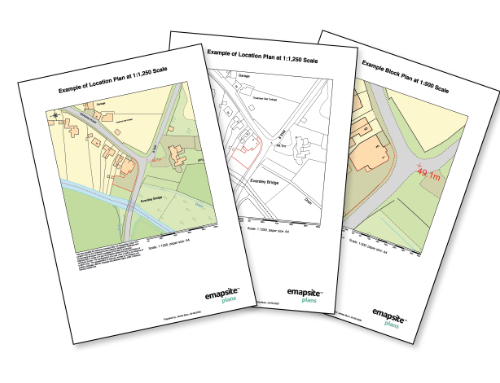
A plan at 1:1250 scale in PDF format tailored for submitting to your local authority for a range of planning applications
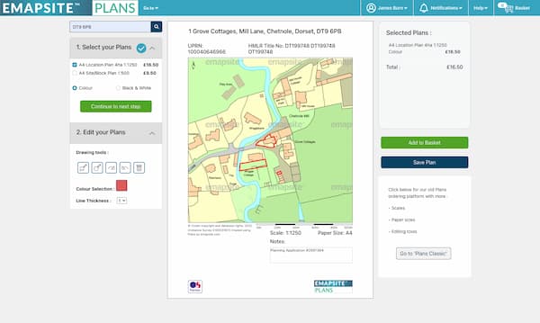
Product DetailsAll PDF plans come complete with a north arrow and scale bar automatically. On Step 2 of Plans Ahead customers can add a range of markups to outline their property and other features.
PDF plans process automatically and customers are emailed the plan within minutes. Unusually large plans are made available to download, which also typically takes just a few minutes. Customers may send the PDFs to their local authority electronically, or print out the PDF as many times as is required for their planning application.
Location Plans (usually at 1:1250 scale) along with Site/Block Plans (at 1:500 scale) can be purchased from our Plans Ahead service online.
Technical Details
- Supplier
- Ordnance Survey
- Update Cycle
- 6 weekly
- Coverage
- GB
- Scale
- 1:1250
- Formats Available
- Stated Accuracy
- Stated Accuracy
- Stated Accuracy
- Licence Options
- Delivery Timescale
- Within minutes
Related Products
OS MasterMap Topography Layer, Aerial Photography
Download Samples
OS MasterMap PDF Site/Block Plan
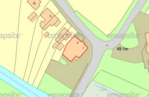
A colour plan at 1:500 scale in PDF format tailored for submitting to your local authority for a range of planning applications.
Product DetailsAll PDF plans come complete with a north arrow and scale bar automatically. On Step 2 of Plans Ahead customers can add a range of markups to outline their property and other features.
PDF plans process automatically and customers are emailed the plan within minutes. Unusually large plans are made available to download, which also typically takes just a few minutes. Customers may send the PDFs to their local authority electronically, or print out the PDF as many times as is required for their planning application.
Site/Block Plans (at 1:500) along with Location Plans (usually at 1:1250 scale) can be purchased from our Plans Ahead service online.
Technical Details
- Supplier
- Ordnance Survey
- Update Cycle
- 6 weekly
- Coverage
- GB
- Scale
- 1:500
- Formats Available
- Stated Accuracy
- Stated Accuracy
- Stated Accuracy
- Licence Options
- Delivery Timescale
Related Products
OS MasterMap Topography Layer, Aerial Photography
Download Samples
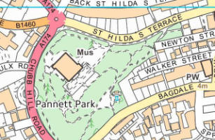
OS VML Detailed Street Plan
A fully customisable PDF plan, created using 1:10,000 scale OS VectorMap Local mapping.
Product DetailsAll PDF plans come complete with a north arrow and scale bar automatically. On Step 2 of Plans Ahead customers can add a range of markups to outline their property and other features.
PDF plans process automatically and customers are emailed the plan within minutes. Unusually large plans are made available to download, which also typically takes just a few minutes.
All PDF plans come complete with a north arrow and scale bar as standard, with customers additionally able to add a title, notes, and a range of mark-ups outlining their area of interest as well as other features.
Technical Details
- Supplier
- Ordnance Survey
- Update Cycle
- Coverage
- GB
- Scale
- 1:10,000 - user can customise print scale
- Formats Available
- Stated Accuracy
- Stated Accuracy
- Stated Accuracy
- Licence Options
- Delivery Timescale
- Within minutes
Related Products
OS VectorMap Local, OS VectorMap Local Raster, OS MasterMap Topography Layer, Aerial Photography